
FCCInfo.com
A Service of Cavell, Mertz & Associates, Inc.
(855) FCC-INFO
|
|
KFXA from 12/10/1985 |
Virtual Channel 28 |
|
||||||||||||||||||||||
|
|
Repacking Information: No changes Status: License Application Accepted: 07/13/2005 License Expires: 02/01/2022 File Number: BLCDT-20050713ABD Prefix Type: This is a License for a commercial digital TV station FCC Website Links: LMS Facility Details This Application Other KFXA Applications Including Superseded Applications Mailing Address Correspondence for KFXA Correspondence related to application BLCDT-20050713ABD Service Contour - Open Street Map or USGS Map (41 dBu) Service Contour - KML / Google Earth (41 dBu) Public Inspection Files Rabbit Ears Info Search for KFXA Site Location: 42-05-25.0 N 92-05-14.0 W (NAD 83) Site Location: 42-05-25.0 N 92-05-13.3 W (Converted to NAD 27) ERP: 1000 kW Polarization: Horizontally polarized HAAT: 449 m (1473 ft.) Electrical Beam Tilt: 0.75 degrees R/C AGL: 453 m (1486 ft.) R/C AMSL: 728 m (2388 ft.) Site Elevation: 275 m. (902 ft.) Height Overall*: 463 m (1519 ft.) (* As Filed In This Application, may differ from ASR Data, Below.) Directional Antenna - Antenna Make/Model: DIELECTRIC TFU-30GTH-R 4P210 DC Antenna ID: 29380 Polarization: Horizontally polarized | ||||||||||||||||||||||||
| Antenna Data for Antenna Id: 29380 KFXA DT File: BLCDT-20050713ABD DIELECTRIC - TFU-30GTH-R 4P210 DC Service: DT Standard Pattern: Y | 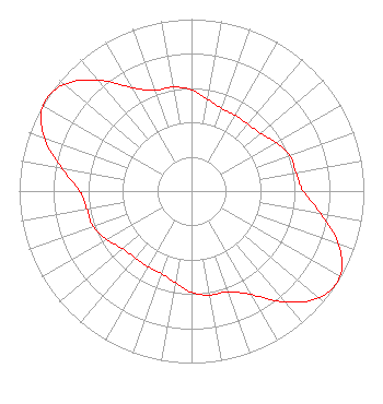 | ||||||||||||||||||||||||
| Azimuth | Ratio | Azimuth | Ratio | Azimuth | Ratio | Azimuth | Ratio | ||||||||||||||||||
| 0 | 0.590 | 10 | 0.541 | 20 | 0.511 | 30 | 0.508 | ||||||||||||||||||
| 40 | 0.508 | 50 | 0.522 | 60 | 0.566 | 70 | 0.606 | ||||||||||||||||||
| 80 | 0.616 | 90 | 0.648 | 100 | 0.762 | 110 | 0.911 | ||||||||||||||||||
| 120 | 0.996 | 130 | 0.966 | 140 | 0.839 | 150 | 0.695 | ||||||||||||||||||
| 160 | 0.623 | 170 | 0.613 | 180 | 0.590 | 190 | 0.541 | ||||||||||||||||||
| 200 | 0.511 | 210 | 0.508 | 220 | 0.508 | 230 | 0.522 | ||||||||||||||||||
| 240 | 0.566 | 250 | 0.606 | 260 | 0.616 | 270 | 0.648 | ||||||||||||||||||
| 280 | 0.762 | 290 | 0.911 | 300 | 0.996 | 310 | 0.966 | ||||||||||||||||||
| 320 | 0.839 | 330 | 0.695 | 340 | 0.623 | 350 | 0.613 | ||||||||||||||||||
Structure Registration Number 1001082 Structure Type: TOWER Registered To: Second Generation of Iowa Ltd Structure Address: 6417 21st Ave Dr Van Horne, IA County Name: Benton County ASR Issued: 12/26/2007 Date Built: 09/12/1996 Site Elevation: 275 m (902 ft.) Structure Height: 444 m (1457 ft.) Height Overall: 463 m (1519 ft.) Overall Height AMSL: 738 m (2421 ft.) FAA Determination: 07/11/1996 FAA Study #: 96-ACE-0376-OE FAA Circular #: 70/7460-1J Paint & Light FAA Chapters: 4, 7, 13 STRUCTURE REACHED ITS GREATEST HEIGHT ON 9/1/96 42-05-25.0 N 92-05-14.0 W (NAD 83) 42-05-25.0 N 92-05-13.3 W (Converted to NAD 27) |
Second Generation Place 3029 Prospect Avenue Cleveland, OH 44115 Phone: 216-361-1000 Limited Liability Company | Date: 07/13/2005 Application Certifier SECOND GENERATION OF IOWA LTD Second Generation Place 3029 Prospect Street Cleveland, OH 44115 Applicant ELMER L. STEINGASS 2324 N. Cleveland-massillon Road P.o. Box 807 Bath, OH 44210-0807 CONSULTING ENGINEER DAVID TILLOTSON Law Office Of David Tillotson 4606 Charleston Terrace, N.w. Washington, DC 20007-1911 | |||||||||||||||||||||||
| |||||||||||||||||||||||||