
FCCInfo.com
A Service of Cavell, Mertz & Associates, Inc.
(855) FCC-INFO
|
|
KSMN from 11/20/1995 |
Virtual Channel 20 |  |
|
||||||||||||||||||||||||
|
|
Repacking Information: No changes Status: License Application Accepted: 12/19/2005 License Expires: 04/01/2022 File Number: BLEDT-20051219AGX Prefix Type: This is a license for a noncommercial educational digital TV station FCC Website Links: LMS Facility Details This Application Other KSMN Applications Including Superseded Applications Mailing Address Correspondence for KSMN Correspondence related to application BLEDT-20051219AGX Service Contour - Open Street Map or USGS Map (41 dBu) Service Contour - KML / Google Earth (41 dBu) Public Inspection Files Rabbit Ears Info Search for KSMN Site Location: 43-53-52.0 N 95-56-51.0 W (NAD 83) Site Location: 43-53-52.1 N 95-56-49.9 W (Converted to NAD 27) ERP: 200 kW Polarization: Horizontally polarized HAAT: 290.1 m (952 ft.) Electrical Beam Tilt: 0.5 degrees R/C AGL: 253 m (830 ft.) R/C AMSL: 809.3 m (2655 ft.) Site Elevation: 556.3 m. (1825 ft.) Height Overall*: 305.7 m (1003 ft.) (* As Filed In This Application, may differ from ASR Data, Below.) Directional Antenna - Antenna Make/Model: DIELECTRIC TFU-24DSC-R S180 Antenna ID: 33521 Polarization: Horizontally polarized | |||||||||||||||||||||||||||
| Antenna Data for Antenna Id: 33521 KSMN DT File: BLEDT-20051219AGX DIELECTRIC - TFU-24DSC-R S180 Service: DT Standard Pattern: Y | 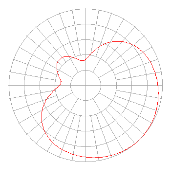 | |||||||||||||||||||||||||||
| Azimuth | Ratio | Azimuth | Ratio | Azimuth | Ratio | Azimuth | Ratio | |||||||||||||||||||||
| 0 | 0.335 | 10 | 0.417 | 20 | 0.533 | 30 | 0.647 | |||||||||||||||||||||
| 40 | 0.741 | 50 | 0.812 | 60 | 0.860 | 70 | 0.893 | |||||||||||||||||||||
| 80 | 0.917 | 90 | 0.939 | 100 | 0.959 | 110 | 0.977 | |||||||||||||||||||||
| 120 | 0.991 | 130 | 0.999 | 135 | 1.000 | 140 | 0.999 | |||||||||||||||||||||
| 150 | 0.991 | 160 | 0.977 | 170 | 0.959 | 180 | 0.939 | |||||||||||||||||||||
| 190 | 0.917 | 200 | 0.893 | 210 | 0.860 | 220 | 0.812 | |||||||||||||||||||||
| 230 | 0.741 | 240 | 0.647 | 250 | 0.533 | 260 | 0.417 | |||||||||||||||||||||
| 270 | 0.335 | 280 | 0.323 | 290 | 0.372 | 300 | 0.432 | |||||||||||||||||||||
| 310 | 0.470 | 320 | 0.470 | 330 | 0.432 | 340 | 0.372 | |||||||||||||||||||||
| 350 | 0.323 | |||||||||||||||||||||||||||
Structure Registration Number 1003305 Structure Type: TOWER Registered To: WEST CENTRAL MN EDUC TV CO INC Structure Address: On Hwy 91 1.5 Mi S Chandler, MN County Name: Murray County ASR Issued: 10/23/1996 Date Built: 12/31/1996 Site Elevation: 556.3 m (1825 ft.) Structure Height: 304.7 m (1000 ft.) Height Overall: 305.7 m (1003 ft.) Overall Height AMSL: 862 m (2828 ft.) FAA Determination: 08/24/1990 FAA Study #: 90-AGL-410-OE FAA Circular #: 70/7460-1G Paint & Light FAA Chapters: 3, 4, 5, 9 43-53-52.0 N 95-56-51.0 W (NAD 83) 43-53-52.1 N 95-56-49.9 W (Converted to NAD 27) |
1 Pioneer Drive Granite Falls, MN 56241 Phone: 320-289-2915 Not-for-Profit | Date: 12/19/2005 Application Certifier WEST CENTRAL MINNESOTA EDUC'L TELEVISION COMPANY 120 West Schleiman Avenue Appleton, MN 56208 Applicant JON PANZER 120 West Schlieman Avenue Appleton, MN 56208 DIRECTOR OF ENGINEERING HARRY C. MARTIN, ESQUIRE Fletcher, Heald & Hildreth, Plc 1300 North 17th Street 11th Floor Arlington, VA 22209 | ||||||||||||||||||||||||||
| ||||||||||||||||||||||||||||