FCCInfo.com
A Service of Cavell, Mertz & Associates, Inc.
(855) FCC-INFO
|
|
WBDL-LP from 08/24/2021 WBOO-LP from ??? WZRK-LP from 02/22/2017 WMKQ-LP from 06/12/2015 WBWI-LP from 02/18/2015 WMBZ-LP from 07/18/2014 WROE-LP from 09/16/2010 W45CF from 10/01/2001 |
|
|
||||||||||||||||
|
|
Status: LIC Application Accepted: 10/21/2004 License Expires: 12/01/2029 File Number: BLTTL-20041021ACA Prefix Type: This is a license for a UHF LPTV station FCC Website Links: LMS Facility Details This Application Other WBDL-LD Applications Including Superseded Applications Service Contour - Open Street Map or USGS Map (74 dBu) Service Contour - KML / Google Earth (74 dBu) Public Inspection Files Rabbit Ears Info Search for WBDL-LD Site Location: 44-53-05.0 N 91-23-27.0 W (NAD 83) Site Location: 44-53-05.1 N 91-23-26.4 W (Converted to NAD 27) ERP: 1 kW R/C AGL: 140 m (459 ft.) R/C AMSL: 420.1 m (1378 ft.) Calculated Site Elevation: 280.1 m. (919 ft.) Height Overall*: 150.9 m (495 ft.) (* As Filed In This Application, may differ from ASR Data, Below.) Directional Antenna - Antenna Make/Model: Andrew SLP16L2-HSOC Antenna ID: 39321 | ||||||||||||||||||
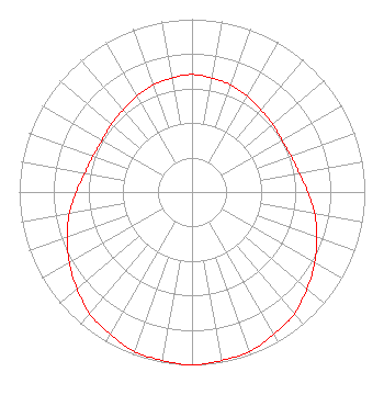
| Antenna Data for Antenna Id: 39321 WBDL-LD TX File: BLTTL-20041021ACA Andrew - SLP16L2-HSOC Service: TX Standard Pattern: Y Pattern and Field Values Include a 180° Clockwise Rotation |  | ||||||||||||||||||
| Azimuth | Ratio | Azimuth | Ratio | Azimuth | Ratio | Azimuth | Ratio | ||||||||||||
| 0 | 0.680 | 10 | 0.670 | 20 | 0.660 | 30 | 0.640 | ||||||||||||
| 40 | 0.620 | 50 | 0.610 | 60 | 0.600 | 70 | 0.610 | ||||||||||||
| 80 | 0.630 | 90 | 0.670 | 100 | 0.720 | 110 | 0.770 | ||||||||||||
| 120 | 0.820 | 130 | 0.870 | 140 | 0.920 | 150 | 0.950 | ||||||||||||
| 160 | 0.980 | 170 | 0.990 | 180 | 1.000 | 190 | 0.990 | ||||||||||||
| 200 | 0.980 | 210 | 0.950 | 220 | 0.920 | 230 | 0.870 | ||||||||||||
| 240 | 0.820 | 250 | 0.770 | 260 | 0.720 | 270 | 0.670 | ||||||||||||
| 280 | 0.630 | 290 | 0.610 | 300 | 0.600 | 310 | 0.610 | ||||||||||||
| 320 | 0.620 | 330 | 0.640 | 340 | 0.660 | 350 | 0.670 | ||||||||||||
Structure Registration Number 1034803 Structure Type: GTOWER Registered To: Clear Water Brands, Inc. Structure Address: Sw Corner Int Cth P & Cth Oo Chippewa Falls, WI County Name: Chippewa County ASR Issued: 07/23/2020 Date Built: 01/01/1980 Site Elevation: 280.1 m (919 ft.) Structure Height: 150 m (492 ft.) Height Overall: 150.9 m (495 ft.) Overall Height AMSL: 431 m (1414 ft.) FAA Determination: 02/11/2020 FAA Study #: 2020-AGL-2644-OE FAA Circular #: 70/7460-1L Paint & Light FAA Chapters: 4, 8, 12 44-53-05.0 N 91-23-26.6 W (NAD 83) 44-53-05.1 N 91-23-26.0 W (Converted to NAD 27) |
141 6th Street South PO Box 1867 Lacrosse, WI 54601 Phone: 608-271-4231 Limited Liability Company | Date: 10/21/2004 Application Certifier White Eagle Partnership 505 King Street Suite 221 LA Crosse, WI 54601 Applicant Richard Wilson 505 King Street Suite 221 LA Crosse, WI 54601 General Partner J. Richard Carr, Esq. | |||||||||||||||||