
FCCInfo.com
A Service of Cavell, Mertz & Associates, Inc.
(855) FCC-INFO
|
|
|
Virtual Channel 29 |  |
|
|||||||||||||||
|
|
Repacking Information: No changes Status: License Application Accepted: 03/17/2006 License Expires: 08/01/2022 File Number: BLCDT-20060317AGE Prefix Type: This is a License for a commercial digital TV station FCC Website Links: LMS Facility Details This Application Other KMPX Applications Including Superseded Applications Mailing Address Correspondence for KMPX Correspondence related to application BLCDT-20060317AGE Service Contour - Open Street Map or USGS Map (41 dBu) Service Contour - KML / Google Earth (41 dBu) Public Inspection Files Rabbit Ears Info Search for KMPX Site Location: 32-35-20.0 N 96-58-05.9 W (NAD 83) Site Location: 32-35-19.5 N 96-58-04.9 W (Converted to NAD 27) ERP: 1000 kW Polarization: Horizontally polarized HAAT: 544.1 m (1785 ft.) Electrical Beam Tilt: 1 degree R/C AGL: 490.8 m (1610 ft.) R/C AMSL: 735.5 m (2413 ft.) Site Elevation: 244.7 m. (803 ft.) Height Overall*: 501.7 m (1646 ft.) (* As Filed In This Application, may differ from ASR Data, Below.) Directional Antenna - Antenna Make/Model: DIELECTRIC TFU-30DSC-R 4S200DC Antenna ID: 65411 Polarization: Horizontally polarized | ||||||||||||||||||
| Antenna Data for Antenna Id: 65411 KMPX DT File: BLCDT-20060317AGE DIELECTRIC - TFU-30DSC-R 4S200DC Service: DT Standard Pattern: Y | 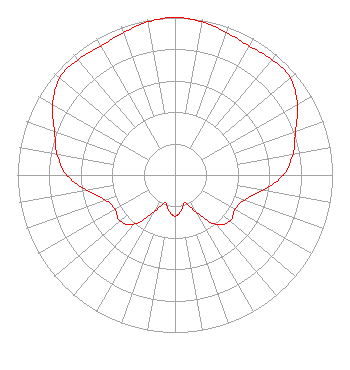 | ||||||||||||||||||
| Azimuth | Ratio | Azimuth | Ratio | Azimuth | Ratio | Azimuth | Ratio | ||||||||||||
| 0 | 1.000 | 10 | 0.988 | 20 | 0.961 | 30 | 0.945 | ||||||||||||
| 40 | 0.957 | 50 | 0.957 | 60 | 0.897 | 70 | 0.814 | ||||||||||||
| 80 | 0.761 | 90 | 0.688 | 100 | 0.567 | 110 | 0.467 | ||||||||||||
| 120 | 0.439 | 130 | 0.455 | 140 | 0.409 | 150 | 0.277 | ||||||||||||
| 160 | 0.186 | 170 | 0.228 | 180 | 0.262 | 190 | 0.228 | ||||||||||||
| 200 | 0.186 | 210 | 0.277 | 220 | 0.409 | 230 | 0.455 | ||||||||||||
| 240 | 0.439 | 250 | 0.467 | 260 | 0.567 | 270 | 0.688 | ||||||||||||
| 280 | 0.761 | 290 | 0.814 | 300 | 0.897 | 310 | 0.957 | ||||||||||||
| 320 | 0.957 | 330 | 0.945 | 340 | 0.961 | 350 | 0.988 | ||||||||||||
Structure Registration Number 1045531 [ASR Heights Differ from KMPX Application] Structure Type: GTOWER Registered To: American Towers LLC Structure Address: 1310 West Beltline Road (cowboy Tower/dallas #75256) Cedar Hill, TX County Name: Dallas County ASR Issued: 09/20/2023 Date Built: 09/19/2008 Site Elevation: 243.8 m (800 ft.) Structure Height: 480.7 m (1577 ft.) Height Overall: 506.2 m (1661 ft.) Overall Height AMSL: 750 m (2461 ft.) FAA Determination: 04/10/2023 FAA Study #: 2022-ASW-23640-OE FAA Circular #: 70/7460-1M Paint & Light FAA Chapters: 4, 9, 15 PRIOR STUDY 2005-ASW-25-OE 32-35-20.0 N 96-58-05.9 W (NAD 83) 32-35-19.5 N 96-58-04.9 W (Converted to NAD 27) |
8350 Broad Street Suite 2000 Tysons, VA 22102 Phone: 703-873-6606 Corporation | Date: 03/17/2006 Application Certifier LIBERMAN TELEVISION OF DALLAS LICENSE CORP. 1845 Empire Avenue Burbank, CA 91504 Applicant JOSEPH M. DAVIS, P.E. Cavell, Mertz & Davis, Inc 7839 Ashton Avenue Manassas, VA 20109 CONSULTING ENGINEER MARNIE K. SARVER Wiley Rein & Fielding Llp 1776 K Street, Nw Washington, DC 20006 | |||||||||||||||||