
FCCInfo.com
A Service of Cavell, Mertz & Associates, Inc.
(855) FCC-INFO
|
|
|
Virtual Channel 13 |  |
|
|||||||||||||||||||||||||||||||||
|
|
Repacking Information: No changes Status: License Application Accepted: 09/11/2003 License Expires: 10/01/2022 File Number: BLCDT-20030911AAI Prefix Type: This is a License for a commercial digital TV station FCC Website Links: LMS Facility Details This Application Other KOLD-TV Applications Including Superseded Applications Mailing Address Correspondence for KOLD-TV Correspondence related to application BLCDT-20030911AAI Service Contour - Open Street Map or USGS Map (41 dBu) Service Contour - KML / Google Earth (41 dBu) Public Inspection Files History Cards for KOLD-TV Rabbit Ears Info Search for KOLD-TV Site Location: 32-24-56.0 N 110-42-52.0 W (NAD 83) Site Location: 32-24-55.7 N 110-42-49.7 W (Converted to NAD 27) ERP: 108 kW Polarization: Horizontally polarized HAAT: 1123 m (3684 ft.) Electrical Beam Tilt: 1.2 degrees R/C AGL: 53 m (174 ft.) R/C AMSL: 2659 m (8724 ft.) Site Elevation: 2606 m. (8550 ft.) Height Overall*: 61.5 m (202 ft.) (* As Filed In This Application, may differ from ASR Data, Below.) Directional Antenna - Antenna Make/Model: DIELECTRIC TUA-C3-12/36H-1-R Antenna ID: 43979 Polarization: Horizontally polarized | ||||||||||||||||||||||||||||||||||||
| Antenna Data for Antenna Id: 43979 KOLD-TV DT File: BLCDT-20030911AAI DIELECTRIC - TUA-C3-12/36H-1-R Service: DT Standard Pattern: Y | 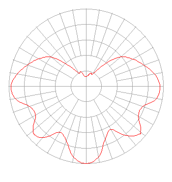 | ||||||||||||||||||||||||||||||||||||
| Azimuth | Ratio | Azimuth | Ratio | Azimuth | Ratio | Azimuth | Ratio | ||||||||||||||||||||||||||||||
| 0 | 0.121 | 10 | 0.138 | 20 | 0.176 | 30 | 0.184 | ||||||||||||||||||||||||||||||
| 40 | 0.363 | 50 | 0.583 | 60 | 0.698 | 70 | 0.794 | ||||||||||||||||||||||||||||||
| 80 | 0.899 | 90 | 0.955 | 100 | 0.925 | 110 | 0.779 | ||||||||||||||||||||||||||||||
| 120 | 0.783 | 130 | 0.917 | 132 | 0.925 | 140 | 0.837 | ||||||||||||||||||||||||||||||
| 150 | 0.646 | 160 | 0.727 | 170 | 0.930 | 180 | 1.000 | ||||||||||||||||||||||||||||||
| 190 | 0.931 | 200 | 0.748 | 210 | 0.689 | 220 | 0.863 | ||||||||||||||||||||||||||||||
| 226 | 0.912 | 230 | 0.890 | 240 | 0.754 | 250 | 0.775 | ||||||||||||||||||||||||||||||
| 260 | 0.928 | 270 | 0.969 | 280 | 0.902 | 290 | 0.801 | ||||||||||||||||||||||||||||||
| 300 | 0.704 | 310 | 0.579 | 320 | 0.348 | 330 | 0.196 | ||||||||||||||||||||||||||||||
| 340 | 0.196 | 350 | 0.134 | ||||||||||||||||||||||||||||||||||
Structure Registration Number 1007178 Structure Type: Registered To: Gray Media Group, Inc. Structure Address: Top Of Mount Bigelow 18 Mi Ne Tucson, AZ County Name: Pima County ASR Issued: 02/11/2019 Date Built: 09/01/1961 Site Elevation: 2606 m (8550 ft.) Structure Height: 45.7 m (150 ft.) Height Overall: 61.5 m (202 ft.) Overall Height AMSL: 2667.5 m (8752 ft.) Paint & Light FAA Chapters: 1, 3, 11, 21 32-24-56.0 N 110-42-52.0 W (NAD 83) 32-24-55.7 N 110-42-49.7 W (Converted to NAD 27) |
4370 Peachtree Road, Ne Atlanta, GA 30319 Phone: 404-504-9828 Limited Liability Company | Date: 09/11/2003 Application Certifier RAYCOM AMERICA, INC. Rsa Tower, 20th Floor 201 Monroe Street Montgomery, AL 36104 Applicant ROBERT E. THURBER, JR. 201 Monroe Street Rsa Tower, 20th Floor Montgomery, AL 36104 DIRECTOR OF ENGINEERING WILLIAM H. FITZ Covington & Burling 1201 Pennsylvania Ave., N.w. Washington, DC 20004-2401 | |||||||||||||||||||||||||||||||||||
|
| ||||||||||||||||||||||||||||||||||||