
FCCInfo.com
A Service of Cavell, Mertz & Associates, Inc.
(855) FCC-INFO
|
|
KRRI-LD from 10/15/1999 KRRI-LD from 09/23/1997 KRRI-LD from 03/22/1994 |
|
|
||||||||||||||||
|
|
Status: License (Licensed And Silent) Application Accepted: 10/28/1998 License Expires: 10/01/2022 File Number: BLTTL-19981028JG Prefix Type: This is a license for a UHF LPTV station FCC Website Links: LMS Facility Details This Application Other KRRI-LD Applications Including Superseded Applications Mailing Address Correspondence for KRRI-LD Correspondence related to application BLTTL-19981028JG Service Contour - Open Street Map or USGS Map (74 dBu) Service Contour - KML / Google Earth (74 dBu) Rabbit Ears Info Search for KRRI-LD Site Location: 39-35-01.8 N 119-47-54.8 W (NAD 83) Site Location: 39-35-02.1 N 119-47-51.1 W (Converted to NAD 27) ERP: 13.4 kW Polarization: Horizontally polarized Max Effective Radiated Power: 13.4 kW R/C AGL: 35 m (115 ft.) R/C AMSL: 1697 m (5568 ft.) Calculated Site Elevation: 1662 m. (5453 ft.) Height Overall*: 53 m (174 ft.) (* As Filed In This Application, may differ from ASR Data, Below.) Directional Antenna - Antenna Make/Model: Antenna Concepts Inc. ACS16E Antenna ID: 17730 Polarization: Horizontally polarized | ||||||||||||||||||
| Antenna Data for Antenna Id: 17730 KRRI-LD TX File: BLTTL-19981028JG Antenna Concepts Inc. - ACS16E Service: TX Standard Pattern: Y Pattern and Field Values Include a 180° Clockwise Rotation | 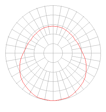 | ||||||||||||||||||
| Azimuth | Ratio | Azimuth | Ratio | Azimuth | Ratio | Azimuth | Ratio | ||||||||||||
| 0 | 0.560 | 10 | 0.560 | 20 | 0.560 | 30 | 0.550 | ||||||||||||
| 40 | 0.540 | 50 | 0.540 | 60 | 0.540 | 70 | 0.560 | ||||||||||||
| 80 | 0.580 | 90 | 0.620 | 100 | 0.680 | 110 | 0.740 | ||||||||||||
| 120 | 0.800 | 130 | 0.860 | 140 | 0.900 | 150 | 0.940 | ||||||||||||
| 160 | 0.980 | 170 | 0.990 | 180 | 1.000 | 190 | 0.990 | ||||||||||||
| 200 | 0.980 | 210 | 0.940 | 220 | 0.900 | 230 | 0.860 | ||||||||||||
| 240 | 0.800 | 250 | 0.740 | 260 | 0.680 | 270 | 0.620 | ||||||||||||
| 280 | 0.580 | 290 | 0.560 | 300 | 0.540 | 310 | 0.540 | ||||||||||||
| 320 | 0.540 | 330 | 0.550 | 340 | 0.560 | 350 | 0.560 | ||||||||||||
Structure Registration Number 1025067 [ASR Heights Differ from KRRI-LD Application] Structure Type: LTOWER Registered To: American Towers LLC Structure Address: 2030 W. 1st Avenue (east Red Peak 1 #8732) Sun Valley, NV County Name: Washoe County ASR Issued: 06/12/2014 Date Built: 06/09/2006 Site Elevation: 1665.3 m (5464 ft.) Structure Height: 39.9 m (131 ft.) Height Overall: 50.3 m (165 ft.) Overall Height AMSL: 1715.6 m (5629 ft.) FAA Determination: 06/04/2014 FAA Study #: 2014-AWP-2145-OE Paint & Light FAA Chapters: NONE PRIOR STUDY 2006-AWP-3139-OE 39-35-01.8 N 119-47-54.8 W (NAD 83) 39-35-02.1 N 119-47-51.1 W (Converted to NAD 27) |
4400 Ne 77th Ave Suite 272 Vancouver, WA 20036 Phone: 202-293-0567 Corporation | Date: 10/28/1998 Application Certifier RENO TV PARTNERS Reno Tv Partners 860 U.s. Highway 1 Suite 108 North Palm Beach, FL 33408 Applicant | |||||||||||||||||