
FCCInfo.com
A Service of Cavell, Mertz & Associates, Inc.
(855) FCC-INFO
|
|
WPNY-LD from 10/07/1996 WPNY-LD from 12/22/1995 WPNY-LD from 01/11/1988 |
|
|
||||||||||||||||
|
|
Status: License Application Accepted: 04/28/2006 License Expires: 06/01/2007 File Number: BLTVL-20060428ABO Prefix Type: This is a license for a VHF LPTV station FCC Website Links: LMS Facility Details This Application Other WPNY-LD Applications Including Superseded Applications Mailing Address Correspondence for WPNY-LD Correspondence related to application BLTVL-20060428ABO Service Contour - Open Street Map or USGS Map (68 dBu) Service Contour - KML / Google Earth (68 dBu) Rabbit Ears Info Search for WPNY-LD Site Location: 43-08-43.0 N 75-10-34.0 W (NAD 83) Site Location: 43-08-42.7 N 75-10-35.4 W (Converted to NAD 27) ERP: 0.094 kW R/C AGL: 59.4 m (195 ft.) R/C AMSL: 431.2 m (1415 ft.) Site Elevation: 371.8 m. (1220 ft.) Height Overall*: 130.7 m (429 ft.) (* As Filed In This Application, may differ from ASR Data, Below.) Directional Antenna - Antenna Make/Model: Scala 5XHDCA-10/HCM/HV Antenna ID: 71910 | ||||||||||||||||||
| Antenna Data for Antenna Id: 71910 WPNY-LD TX File: BLTVL-20060428ABO Scala - 5XHDCA-10/HCM/HV Service: TX Standard Pattern: Y | 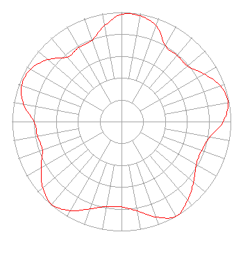 | ||||||||||||||||||
| Azimuth | Ratio | Azimuth | Ratio | Azimuth | Ratio | Azimuth | Ratio | ||||||||||||
| 0 | 0.980 | 10 | 0.980 | 20 | 0.930 | 30 | 0.800 | ||||||||||||
| 40 | 0.790 | 50 | 0.790 | 60 | 0.870 | 70 | 0.960 | ||||||||||||
| 80 | 0.990 | 90 | 0.930 | 100 | 0.820 | 110 | 0.780 | ||||||||||||
| 120 | 0.790 | 130 | 0.860 | 140 | 0.940 | 150 | 1.000 | ||||||||||||
| 160 | 0.930 | 170 | 0.830 | 180 | 0.780 | 190 | 0.790 | ||||||||||||
| 200 | 0.850 | 210 | 0.940 | 220 | 0.990 | 230 | 0.940 | ||||||||||||
| 240 | 0.850 | 250 | 0.770 | 260 | 0.780 | 270 | 0.800 | ||||||||||||
| 280 | 0.910 | 290 | 0.970 | 300 | 0.960 | 310 | 0.880 | ||||||||||||
| 320 | 0.770 | 330 | 0.780 | 340 | 0.790 | 350 | 0.890 | ||||||||||||
Structure Registration Number 1003764 Structure Type: GTOWER Registered To: Mission Broadcasting, Inc. Structure Address: Atop Smith Hill Rd Approx 2 Mi Ne Utica, NY County Name: Oneida County ASR Issued: 03/09/2015 Date Built: 03/11/2015 Site Elevation: 371.8 m (1220 ft.) Structure Height: 113.6 m (373 ft.) Height Overall: 130.7 m (429 ft.) Overall Height AMSL: 502.5 m (1649 ft.) FAA Determination: 01/30/2015 FAA Study #: 2015-AEA-291-OE Paint & Light FAA Chapters: 1, 3, 12, 21 PRIOR STUDY 1979-AEA-423-OE 43-08-41.1 N 75-10-32.2 W (NAD 83) 43-08-40.8 N 75-10-33.6 W (Converted to NAD 27) |
545 E. John Carpenter Freeway Suite 700 Irving, TX 75062 Phone: 972-373-8800 Corporation | Date: 04/28/2006 Application Certifier NEXSTAR BROADCASTING, INC. 909 Lake Carolyn Parkway Suite 1450 Irving, TX 75039 Applicant RYAN M. FELMLEE Cohen, Dippell And Everist, P.c. 1300 L Street Nw #1100 Washington, DC 20005 CONSULTING ENGINEER ELIZABETH HAMMOND Drinker Biddle & Reath Llp | |||||||||||||||||