
FCCInfo.com
A Service of Cavell, Mertz & Associates, Inc.
(855) FCC-INFO
|
|
WAZS-LD from 03/16/2007 |
|
|
||||||||||||||||
|
|
Status: License Application Accepted: 09/16/2010 License Expires: 12/01/2020 File Number: BLDTL-20100916ADH Prefix Type: This is BLDTL FCC Website Links: LMS Facility Details This Application Other WAZS-LD Applications Including Superseded Applications Mailing Address Correspondence for WAZS-LD Correspondence related to application BLDTL-20100916ADH Service Contour - Open Street Map or USGS Map (51 dBu) Service Contour - KML / Google Earth (51 dBu) Rabbit Ears Info Search for WAZS-LD Site Location: 32-55-43.0 N 80-06-12.0 W (NAD 83) Site Location: 32-55-42.4 N 80-06-12.7 W (Converted to NAD 27) ERP: 15 kW Electrical Beam Tilt: 0.5 degrees R/C AGL: 84.4 m (277 ft.) R/C AMSL: 93.8 m (308 ft.) Emission Mask: Stringent Site Elevation: 9.4 m. (31 ft.) Height Overall*: 100 m (328 ft.) (* As Filed In This Application, may differ from ASR Data, Below.) Directional Antenna - Antenna Make/Model: Aldena ATV-08-07-420 Antenna ID: 100207 | ||||||||||||||||||
| Antenna Data for Antenna Id: 100207 WAZS-LD LD File: BLDTL-20100916ADH Aldena - ATV-08-07-420 Service: LD Standard Pattern: Y | 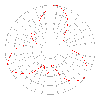 | ||||||||||||||||||
| Azimuth | Ratio | Azimuth | Ratio | Azimuth | Ratio | Azimuth | Ratio | ||||||||||||
| 0 | 0.955 | 10 | 1.000 | 20 | 0.912 | 30 | 0.785 | ||||||||||||
| 40 | 0.582 | 45 | 0.426 | 50 | 0.309 | 60 | 0.431 | ||||||||||||
| 70 | 0.562 | 80 | 0.422 | 90 | 0.473 | 100 | 0.684 | ||||||||||||
| 110 | 0.832 | 120 | 0.955 | 130 | 0.988 | 135 | 0.955 | ||||||||||||
| 140 | 0.902 | 150 | 0.785 | 160 | 0.569 | 170 | 0.331 | ||||||||||||
| 180 | 0.468 | 190 | 0.549 | 200 | 0.380 | 210 | 0.473 | ||||||||||||
| 220 | 0.692 | 225 | 0.767 | 230 | 0.822 | 240 | 0.966 | ||||||||||||
| 250 | 1.000 | 260 | 0.902 | 270 | 0.785 | 280 | 0.569 | ||||||||||||
| 290 | 0.309 | 300 | 0.431 | 310 | 0.543 | 315 | 0.479 | ||||||||||||
| 320 | 0.394 | 330 | 0.473 | 340 | 0.684 | 350 | 0.813 | ||||||||||||
Structure Registration Number 1054307 Structure Type: TOWER Registered To: THOMAS B. DANIELS Structure Address: N. Strayton Dr. 1.6 Km N. Of Ashley Church North Charleston, SC County Name: Dorchester County ASR Issued: 02/21/2001 Date Built: 02/15/2001 Site Elevation: 9.4 m (31 ft.) Structure Height: 99 m (325 ft.) Height Overall: 100 m (328 ft.) Overall Height AMSL: 109.4 m (359 ft.) FAA Determination: 03/27/2000 FAA Study #: 00-ASO-1299-OE Paint & Light FAA Chapters: A1, H, 3, 11, 21, 23 Removed expiration and final dates from determination. Scenario 2./jjs/case#635066 32-55-43.0 N 80-06-12.0 W (NAD 83) 32-55-42.4 N 80-06-12.7 W (Converted to NAD 27) |
4801 East Independence Blvd. Suite 815 Charlotte, NC 28212 Phone: 800-975-0760 Corporation | Date: 09/16/2010 Application Certifier THOMAS B. DANIELS 5081 Rivers Ave. North Charleston, SC 29418 Applicant CHIP EARLEY 5081 Rivers Ave. North Charleston, SC 29406 NETWORK ENGINEER DAN J. ALPERT The Law Office Of Dan J. Alpert | |||||||||||||||||