
FCCInfo.com
A Service of Cavell, Mertz & Associates, Inc.
(855) FCC-INFO
|
|
|
Virtual Channel 20 |
|
||||||||||||||||
|
|
Repacking Information: No changes Status: License Application Accepted: 01/30/2007 License Expires: 02/01/2014 File Number: BLCDT-20070130AJQ Prefix Type: This is a License for a commercial digital TV station FCC Website Links: LMS Facility Details This Application Other KWKB Applications Including Superseded Applications Mailing Address Correspondence for KWKB Correspondence related to application BLCDT-20070130AJQ Service Contour - Open Street Map or USGS Map (41 dBu) Service Contour - KML / Google Earth (41 dBu) Public Inspection Files Rabbit Ears Info Search for KWKB Site Location: 41-43-29.2 N 91-21-10.2 W (NAD 83) Site Location: 41-43-29.1 N 91-21-09.6 W (Converted to NAD 27) ERP: 1000 kW Polarization: Horizontally polarized HAAT: 418.9 m (1374 ft.) Electrical Beam Tilt: 0.75 degrees R/C AGL: 410.6 m (1347 ft.) R/C AMSL: 652.3 m (2140 ft.) Site Elevation: 241.7 m. (793 ft.) Height Overall*: 443.8 m (1456 ft.) (* As Filed In This Application, may differ from ASR Data, Below.) Directional Antenna - Antenna Make/Model: Electronics Research Inc. ATW28H3-HCT1-25H Antenna ID: 78683 Polarization: Horizontally polarized | ||||||||||||||||||
| Antenna Data for Antenna Id: 78683 KWKB DT File: BLCDT-20070130AJQ Electronics Research Inc. - ATW28H3-HCT1-25H Service: DT Standard Pattern: Y | 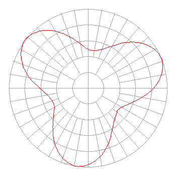 | ||||||||||||||||||
| Azimuth | Ratio | Azimuth | Ratio | Azimuth | Ratio | Azimuth | Ratio | ||||||||||||
| 0 | 0.490 | 10 | 0.480 | 20 | 0.520 | 30 | 0.610 | ||||||||||||
| 40 | 0.750 | 50 | 0.880 | 60 | 0.970 | 68 | 1.000 | ||||||||||||
| 70 | 0.997 | 80 | 0.940 | 90 | 0.830 | 100 | 0.690 | ||||||||||||
| 110 | 0.570 | 120 | 0.490 | 128 | 0.470 | 130 | 0.480 | ||||||||||||
| 140 | 0.520 | 150 | 0.610 | 160 | 0.750 | 170 | 0.880 | ||||||||||||
| 180 | 0.970 | 188 | 1.000 | 190 | 0.997 | 200 | 0.940 | ||||||||||||
| 210 | 0.830 | 220 | 0.690 | 230 | 0.570 | 240 | 0.490 | ||||||||||||
| 250 | 0.480 | 260 | 0.520 | 270 | 0.610 | 280 | 0.750 | ||||||||||||
| 290 | 0.880 | 300 | 0.970 | 308 | 1.000 | 310 | 0.997 | ||||||||||||
| 320 | 0.940 | 330 | 0.830 | 340 | 0.690 | 350 | 0.570 | ||||||||||||
Structure Registration Number 1062919 Structure Type: TOWER Registered To: Faith Broadcasting Network, Inc. Structure Address: 1547 Baker Avenue West Branch, IA County Name: Cedar County ASR Issued: 08/02/2021 Date Built: 08/30/1999 Site Elevation: 241.7 m (793 ft.) Structure Height: 422.5 m (1386 ft.) Height Overall: 443.8 m (1456 ft.) Overall Height AMSL: 685.5 m (2249 ft.) FAA Determination: 07/28/2000 FAA Study #: 00-ACE-1220-OE Paint & Light FAA Chapters: A1, B, F, H CONTINUE OM&L 24 HR HI STROBES 41-43-29.2 N 91-21-10.2 W (NAD 83) 41-43-29.1 N 91-21-09.6 W (Converted to NAD 27) |
P. O. Box 1010 Marion, IL 65909 Phone: 618-997-4700 Not-for-Profit | Date: 01/30/2007 Application Certifier KM TELEVISION OF IOWA, L.L.C. 3654 West Jarvis Avenue Skokie, IL 60076 Applicant TIMOTHY Z. SAWYER 9049 Shady Grove Court Gaithersburg, MD 20877 CONSULTING ENGINEER JEFFREY L. TIMMONS, ESQ. Jeffrey L. Timmons, P.c. 1400 Buford Highway, Suite G-5 Sugar Hill, GA 30518-8727 | |||||||||||||||||