
FCCInfo.com
A Service of Cavell, Mertz & Associates, Inc.
(855) FCC-INFO
|
|
|
Virtual Channel 15 |
|
|||||||||||||||||||||||||
|
|
Repacking Information: No changes Status: License Application Accepted: 05/20/2011 License Expires: 08/01/2022 File Number: BLCDT-20110520ADO Prefix Type: This is a License for a commercial digital TV station FCC Website Links: LMS Facility Details This Application Other KXVA Applications Including Superseded Applications Mailing Address Correspondence for KXVA Correspondence related to application BLCDT-20110520ADO Service Contour - Open Street Map or USGS Map (41 dBu) Service Contour - KML / Google Earth (41 dBu) Public Inspection Files Rabbit Ears Info Search for KXVA Site Location: 32-16-31.6 N 99-35-24.6 W (NAD 83) Site Location: 32-16-31.1 N 99-35-23.3 W (Converted to NAD 27) ERP: 31 kW Polarization: Horizontally polarized HAAT: 299 m (981 ft.) R/C AGL: 235 m (771 ft.) R/C AMSL: 900 m (2953 ft.) Site Elevation: 665 m. (2182 ft.) Height Overall*: 246 m (807 ft.) (* As Filed In This Application, may differ from ASR Data, Below.) Directional Antenna - Antenna Make/Model: Propagation System Inc USMD32MCA/15 Antenna ID: 105124 Polarization: Horizontally polarized
| |||||||||||||||||||||||||||
| Antenna Data for Antenna Id: 105124 KXVA DT File: BLCDT-20110520ADO Propagation System Inc - USMD32MCA/15 Service: DT Standard Pattern: Y | 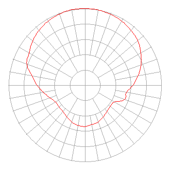 | |||||||||||||||||||||||||||
| Azimuth | Ratio | Azimuth | Ratio | Azimuth | Ratio | Azimuth | Ratio | |||||||||||||||||||||
| 0 | 1.000 | 10 | 0.996 | 20 | 0.984 | 30 | 0.964 | |||||||||||||||||||||
| 40 | 0.934 | 50 | 0.900 | 60 | 0.843 | 70 | 0.780 | |||||||||||||||||||||
| 80 | 0.706 | 90 | 0.628 | 100 | 0.551 | 110 | 0.550 | |||||||||||||||||||||
| 120 | 0.443 | 130 | 0.432 | 140 | 0.448 | 150 | 0.478 | |||||||||||||||||||||
| 160 | 0.511 | 170 | 0.522 | 180 | 0.540 | 190 | 0.532 | |||||||||||||||||||||
| 200 | 0.511 | 210 | 0.478 | 220 | 0.448 | 230 | 0.444 | |||||||||||||||||||||
| 240 | 0.443 | 250 | 0.485 | 260 | 0.551 | 270 | 0.628 | |||||||||||||||||||||
| 280 | 0.706 | 290 | 0.810 | 300 | 0.843 | 310 | 0.895 | |||||||||||||||||||||
| 320 | 0.934 | 330 | 0.964 | 340 | 0.984 | 350 | 1.000 | |||||||||||||||||||||
Structure Registration Number 1212752 Structure Type: TOWER Registered To: KTVK, Inc. Structure Address: 9.38 Nautical Miles Sse Of Abilene Regional Airport Clyde, TX County Name: Callahan County ASR Issued: 02/13/2019 Date Built: 09/19/2012 Site Elevation: 665.1 m (2182 ft.) Structure Height: 245.9 m (807 ft.) Height Overall: 246.3 m (808 ft.) Overall Height AMSL: 911.4 m (2990 ft.) FAA Determination: 04/06/2000 FAA Study #: 99-asw-4554-oe FAA Circular #: 70/7460-1K Paint & Light FAA Chapters: 4, 9, 12 Removed expiration and final dates from determination. Scenario 2./jjs/case#635066 32-16-31.6 N 99-35-24.6 W (NAD 83) 32-16-31.1 N 99-35-23.3 W (Converted to NAD 27) |
Tegna, Inc. 8350 Broad Street, Suite 2000 Tysons, VA 22102 Phone: 703-873-6606 Corporation | Date: 05/20/2011 Application Certifier BAYOUCITYBROADCASTING 406 S Irving San Angelo, TX 76903 Applicant GLENN EDWARDS 406 S Irving San Angelo, TX 76903 EMPLOYEE GLENN EDWARDS Bayoucitybroadcasting | ||||||||||||||||||||||||||
| ||||||||||||||||||||||||||||