
FCCInfo.com
A Service of Cavell, Mertz & Associates, Inc.
(855) FCC-INFO
|
|
K19JX-D from 07/11/2012 |
|
|
||||||||||||||||
|
|
Status: License Application Accepted: 10/16/2014 License Expires: 02/01/2023 File Number: BLDTL-20141016ADC Prefix Type: This is BLDTL FCC Website Links: LMS Facility Details This Application Other K19JX-D Applications Including Superseded Applications Mailing Address Correspondence for K19JX-D Correspondence related to application BLDTL-20141016ADC Service Contour - Open Street Map or USGS Map (51 dBu) Service Contour - KML / Google Earth (51 dBu) Rabbit Ears Info Search for K19JX-D Site Location: 46-31-51.6 N 120-30-54.0 W (NAD 83) Site Location: 46-31-52.1 N 120-30-49.8 W (Converted to NAD 27) ERP: 15 kW Electrical Beam Tilt: 0.25 degrees R/C AGL: 10 m (33 ft.) R/C AMSL: 622 m (2041 ft.) Emission Mask: Full Service Site Elevation: 612 m. (2008 ft.) Height Overall*: 25.5 m (84 ft.) (* As Filed In This Application, may differ from ASR Data, Below.) Directional Antenna - Antenna Make/Model: Andrew ALP8L1-HSWR Antenna ID: 16992 | ||||||||||||||||||
| Antenna Data for Antenna Id: 16992 K19JX-D LD File: BLDTL-20141016ADC Andrew - ALP8L1-HSWR Service: LD Standard Pattern: Y Pattern and Field Values Include a 310° Clockwise Rotation | 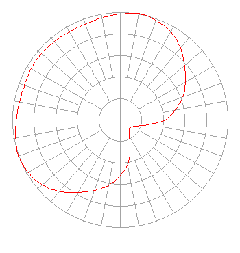 | ||||||||||||||||||
| Azimuth | Ratio | Azimuth | Ratio | Azimuth | Ratio | Azimuth | Ratio | ||||||||||||
| 0 | 0.980 | 10 | 1.000 | 20 | 0.980 | 30 | 0.940 | ||||||||||||
| 40 | 0.870 | 50 | 0.780 | 60 | 0.700 | 70 | 0.620 | ||||||||||||
| 80 | 0.520 | 90 | 0.420 | 100 | 0.270 | 110 | 0.170 | ||||||||||||
| 120 | 0.130 | 130 | 0.120 | 140 | 0.130 | 150 | 0.170 | ||||||||||||
| 160 | 0.270 | 170 | 0.420 | 180 | 0.520 | 190 | 0.620 | ||||||||||||
| 200 | 0.700 | 210 | 0.780 | 220 | 0.870 | 230 | 0.940 | ||||||||||||
| 240 | 0.980 | 250 | 1.000 | 260 | 0.980 | 270 | 0.960 | ||||||||||||
| 280 | 0.945 | 290 | 0.940 | 300 | 0.950 | 310 | 0.950 | ||||||||||||
| 320 | 0.945 | 330 | 0.940 | 340 | 0.945 | 350 | 0.960 | ||||||||||||
Structure Registration Number 1258286 Structure Type: POLE Registered To: Christian Broadcasting of Yakima Structure Address: Ahtanum Ridge Yakima, WA County Name: Yakima County ASR Issued: 05/18/2023 Site Elevation: 612 m (2008 ft.) Structure Height: 25.5 m (84 ft.) Height Overall: 25.5 m (84 ft.) Overall Height AMSL: 637.5 m (2092 ft.) FAA Determination: 04/27/2007 FAA Study #: 2007-ANM-689-OE FAA Circular #: Paint & Light FAA Chapters: NONE PRIOR STUDY 2006-ANM-3824-OE 46-31-51.6 N 120-30-54.0 W (NAD 83) 46-31-52.1 N 120-30-49.8 W (Converted to NAD 27) |
P.o. Box 10745 Yakima, WA 98909 Phone: 509-972-0926 Private Not-for-Profit Educational Institution | Date: 10/16/2014 Application Certifier CHRISTIAN BROADCASTING OF YAKIMA P.o. Box 10745 Yakima, WA 98909-1745 Applicant RAFAEL FERNANDEZ 2402 West 'j' Street Suite F Yakima, WA 98902 ENGINEER/OWNING RESP CHRISTIAN BROADCASTING OF YAKIMA | |||||||||||||||||