
FCCInfo.com
A Service of Cavell, Mertz & Associates, Inc.
(855) FCC-INFO
|
|
|
Virtual Channel 5 |  |
|
|||||||||||||||
|
|
Repacking Information: No changes Status: License Application Accepted: 08/18/2009 License Expires: 10/01/2021 File Number: BLCDT-20090818ABS Prefix Type: This is a License for a commercial digital TV station FCC Website Links: LMS Facility Details This Application Other WBKP Applications Including Superseded Applications Mailing Address Correspondence for WBKP Correspondence related to application BLCDT-20090818ABS Service Contour - Open Street Map or USGS Map (28 dBu) Service Contour - KML / Google Earth (28 dBu) Public Inspection Files Rabbit Ears Info Search for WBKP Site Location: 47-02-11.0 N 88-41-43.0 W (NAD 83) Site Location: 47-02-11.3 N 88-41-42.5 W (Converted to NAD 27) ERP: 6.4 kW Polarization: Horizontally polarized HAAT: 301 m (988 ft.) R/C AGL: 143 m (469 ft.) R/C AMSL: 603 m (1978 ft.) Site Elevation: 460 m. (1509 ft.) Height Overall*: 152 m (499 ft.) (* As Filed In This Application, may differ from ASR Data, Below.) Directional Antenna - Antenna Make/Model: Harris TDA-4MA-2/8 Antenna ID: 85792 Polarization: Horizontally polarized | ||||||||||||||||||
| Antenna Data for Antenna Id: 85792 WBKP DT File: BLCDT-20090818ABS Harris - TDA-4MA-2/8 Service: DT Standard Pattern: Y | 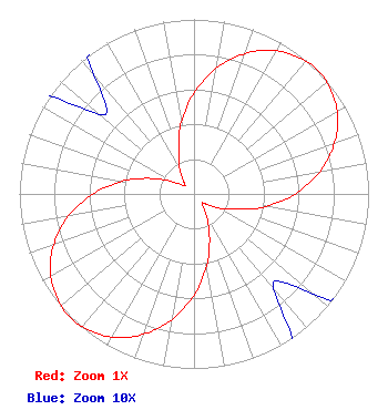 | ||||||||||||||||||
| Azimuth | Ratio | Azimuth | Ratio | Azimuth | Ratio | Azimuth | Ratio | ||||||||||||
| 0 | 0.580 | 10 | 0.731 | 20 | 0.857 | 30 | 0.947 | ||||||||||||
| 40 | 0.994 | 45 | 1.000 | 50 | 0.994 | 60 | 0.947 | ||||||||||||
| 70 | 0.857 | 80 | 0.731 | 90 | 0.580 | 100 | 0.418 | ||||||||||||
| 110 | 0.259 | 120 | 0.164 | 130 | 0.089 | 140 | 0.071 | ||||||||||||
| 150 | 0.137 | 160 | 0.259 | 170 | 0.418 | 180 | 0.580 | ||||||||||||
| 190 | 0.731 | 200 | 0.857 | 210 | 0.947 | 220 | 0.994 | ||||||||||||
| 225 | 1.000 | 230 | 0.994 | 240 | 0.947 | 250 | 0.857 | ||||||||||||
| 260 | 0.731 | 270 | 0.580 | 280 | 0.418 | 290 | 0.259 | ||||||||||||
| 300 | 0.137 | 310 | 0.071 | 320 | 0.089 | 330 | 0.164 | ||||||||||||
| 340 | 0.259 | 350 | 0.418 | ||||||||||||||||
Structure Registration Number 1007829 Structure Type: TOWER Registered To: Queen Bee's Knees, LLC Structure Address: Hwy M-26 1 Mi S Painesdale, MI County Name: Houghton County ASR Issued: 12/13/2023 Date Built: 10/09/1996 Site Elevation: 460 m (1509 ft.) Structure Height: 152 m (499 ft.) Height Overall: 152 m (499 ft.) Overall Height AMSL: 612 m (2008 ft.) FAA Determination: 07/11/1996 FAA Study #: 96-AGL-2067-OE FAA Circular #: 70/7460-1J Paint & Light FAA Chapters: 3, 4, 5, 13 47-02-11.0 N 88-41-43.0 W (NAD 83) 47-02-11.3 N 88-41-42.5 W (Converted to NAD 27) |
7025 Raymond Road Madison, WI 53719 Phone: 608-271-4321 Limited Liability Company | Date: 08/18/2009 Application Certifier LAKE SUPERIOR COMMUNITY BROADCASTING CORPORATION 1705 Ash Street Suite 5 Ishpeming, MI 49849 Applicant JONATHAN N. EDWARDS Du Treil, Lundin & Rackley, Inc. 201 Fletcher Avenue Sarasota, FL 34237 TECHNICAL CONSULTANT BRENDAN HOLLAND Davis Wright Tremaine Llp 1919 Pennsylvania Avenue, Nw Suite 800 Washington, DC 20006-3401 | |||||||||||||||||
| |||||||||||||||||||