
FCCInfo.com
A Service of Cavell, Mertz & Associates, Inc.
(855) FCC-INFO
|
|
WWVW-LD from 09/15/2004 WWVW-LD from 08/10/1999 WWVW-LD from 09/28/1990 |
|
|
||||||||||||||||
|
|
Status: License Application Accepted: 11/02/2012 License Expires: 10/01/2020 File Number: BLDVL-20121102ADW Prefix Type: This is BLDVL FCC Website Links: LMS Facility Details This Application Other WWVW-LD Applications Including Superseded Applications Mailing Address Correspondence for WWVW-LD Correspondence related to application BLDVL-20121102ADW Service Contour - Open Street Map or USGS Map (48 dBu) Service Contour - KML / Google Earth (48 dBu) Rabbit Ears Info Search for WWVW-LD Site Location: 40-03-41.3 N 80-45-07.3 W (NAD 83) Site Location: 40-03-41.0 N 80-45-08.0 W (Converted to NAD 27) ERP: 1.5 kW R/C AGL: 65.4 m (215 ft.) R/C AMSL: 457 m (1499 ft.) Emission Mask: Full Service Site Elevation: 391.6 m. (1285 ft.) Height Overall*: 225 m (738 ft.) (* As Filed In This Application, may differ from ASR Data, Below.) Directional Antenna - Antenna Make/Model: Scala CL-713 Antenna ID: 20786 | ||||||||||||||||||
| Antenna Data for Antenna Id: 20786 WWVW-LD LD File: BLDVL-20121102ADW Scala - CL-713 Service: LD Standard Pattern: Y Pattern and Field Values Include a 350° Clockwise Rotation | 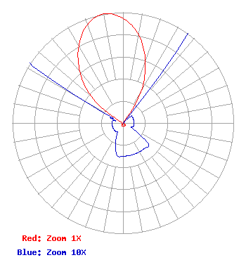 | ||||||||||||||||||
| Azimuth | Ratio | Azimuth | Ratio | Azimuth | Ratio | Azimuth | Ratio | ||||||||||||
| 0 | 0.945 | 10 | 0.810 | 20 | 0.590 | 30 | 0.325 | ||||||||||||
| 40 | 0.010 | 50 | 0.010 | 60 | 0.010 | 70 | 0.010 | ||||||||||||
| 80 | 0.010 | 90 | 0.010 | 100 | 0.010 | 110 | 0.010 | ||||||||||||
| 120 | 0.010 | 130 | 0.030 | 140 | 0.030 | 150 | 0.030 | ||||||||||||
| 160 | 0.030 | 170 | 0.030 | 180 | 0.030 | 190 | 0.030 | ||||||||||||
| 200 | 0.020 | 210 | 0.010 | 220 | 0.010 | 230 | 0.010 | ||||||||||||
| 240 | 0.010 | 250 | 0.010 | 260 | 0.010 | 270 | 0.010 | ||||||||||||
| 280 | 0.010 | 290 | 0.010 | 300 | 0.050 | 310 | 0.380 | ||||||||||||
| 320 | 0.606 | 330 | 0.800 | 340 | 0.945 | 350 | 1.000 | ||||||||||||
Structure Registration Number 1035146 Structure Type: Registered To: Nexstar Media Inc. Structure Address: Twr 1 Kirkwood Hgts Bridgeport, OH County Name: Belmont County ASR Issued: 05/28/2021 Date Built: 02/17/2009 Site Elevation: 391.6 m (1285 ft.) Structure Height: 195 m (640 ft.) Height Overall: 225 m (738 ft.) Overall Height AMSL: 616.6 m (2023 ft.) FAA Determination: 09/04/1962 FAA Study #: 1-OE-1765 Paint & Light FAA Chapters: 1, 3, 5, 14, 21 RED LIGHTS/PAINT 40-03-41.3 N 80-45-07.3 W (NAD 83) 40-03-41.0 N 80-45-08.0 W (Converted to NAD 27) |
C/o Benjamin Perez 514 Chautauqua Street Pittsburgh, PA 15214 Phone: 412-322-5526 Sole Proprietor | Date: 11/02/2012 Application Certifier ABACUS TELEVISION C/o Benjamin Perez 514 Chautauqua Street Pittsburgh, PA 15214-3509 Applicant BENJAMIN PEREZ Abacus Television 514 Chautauqua Street Pittsburgh, PA 15214 CHIEF ENGINEER BENJAMIN PEREZ Abacus Communications Company | |||||||||||||||||