
FCCInfo.com
A Service of Cavell, Mertz & Associates, Inc.
(855) FCC-INFO
|
|
K09VL-D from 06/26/2008 K09VL-D from 05/15/2008 K09VL-D from 06/04/1990 |
|
|
||||||||||||||||
|
|
Status: License Application Accepted: 11/03/2010 License Expires: 04/01/2022 File Number: BLDTV-20101103ACG Prefix Type: This is BLDTV FCC Website Links: LMS Facility Details This Application Other K09VL-D Applications Including Superseded Applications Mailing Address Correspondence for K09VL-D Correspondence related to application BLDTV-20101103ACG Service Contour - Open Street Map or USGS Map (48 dBu) Service Contour - KML / Google Earth (48 dBu) Rabbit Ears Info Search for K09VL-D Site Location: 45-05-30.0 N 105-01-21.3 W (NAD 83) Site Location: 45-05-30.1 N 105-01-19.4 W (Converted to NAD 27) ERP: 0.245 kW R/C AGL: 9 m (30 ft.) R/C AMSL: 1362 m (4469 ft.) Emission Mask: Simple Site Elevation: 1353 m. (4439 ft.) Height Overall*: 12.2 m (40 ft.) (* As Filed In This Application, may differ from ASR Data, Below.) Directional Antenna - Antenna Make/Model: SC HDCA-10 ARRAY Antenna ID: 96272
| ||||||||||||||||||
| Antenna Data for Antenna Id: 96272 K09VL-D LD File: BLDTV-20101103ACG SC - HDCA-10 ARRAY Service: LD Standard Pattern: Y | 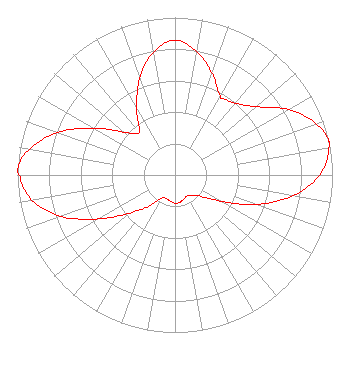 | ||||||||||||||||||
| Azimuth | Ratio | Azimuth | Ratio | Azimuth | Ratio | Azimuth | Ratio | ||||||||||||
| 0 | 0.856 | 10 | 0.797 | 20 | 0.687 | 30 | 0.576 | ||||||||||||
| 33 | 0.575 | 40 | 0.596 | 50 | 0.674 | 60 | 0.831 | ||||||||||||
| 70 | 0.951 | 77 | 1.000 | 80 | 0.992 | 90 | 0.918 | ||||||||||||
| 100 | 0.760 | 110 | 0.549 | 120 | 0.331 | 130 | 0.210 | ||||||||||||
| 140 | 0.173 | 150 | 0.153 | 160 | 0.164 | 170 | 0.176 | ||||||||||||
| 180 | 0.180 | 190 | 0.168 | 200 | 0.161 | 210 | 0.169 | ||||||||||||
| 220 | 0.259 | 230 | 0.376 | 240 | 0.557 | 250 | 0.768 | ||||||||||||
| 260 | 0.922 | 270 | 0.987 | 272 | 1.000 | 280 | 0.938 | ||||||||||||
| 290 | 0.793 | 300 | 0.592 | 310 | 0.424 | 320 | 0.354 | ||||||||||||
| 330 | 0.487 | 340 | 0.654 | 350 | 0.793 | ||||||||||||||
Structure Registration Number 1248473 Structure Type: TOWER Registered To: Powder River, County of Structure Address: On West Butte, 4.8 Km North Of Ridge, MT County Name: Carter County ASR Issued: 05/10/2005 Date Built: 05/19/2006 Site Elevation: 1353.3 m (4440 ft.) Structure Height: 6.1 m (20 ft.) Height Overall: 12.2 m (40 ft.) Overall Height AMSL: 1365.5 m (4480 ft.) FAA Determination: 05/02/2005 FAA Study #: 2005-ANM-934-OE Paint & Light FAA Chapters: NONE Removed expiration date from determination. Scenario 1./jjs/case#635066 45-05-30.0 N 105-01-21.3 W (NAD 83) 45-05-30.1 N 105-01-19.4 W (Converted to NAD 27) |
C/o Clerk & Recorder Office Po Box 270 Broadus, MT 59317 Applicant | Date: 11/03/2010 Application Certifier POWDER RIVER T.V. BOARD P.o. Box 200 Broadus, MT 59317 Applicant B. W. ST. CLAIR 2355 Ranch Drive Westminster, CO 80234 ENGINEERING CONSULTANT WELDON PAULSON Sjl Broadcast Management | |||||||||||||||||