
FCCInfo.com
A Service of Cavell, Mertz & Associates, Inc.
(855) FCC-INFO
|
|
KEKE from 03/14/1989 KEKE from 02/26/1988 |
Virtual Channel 14 |
|
||||||||||||||||
|
|
Repacking Information: No changes Status: License Application Accepted: 06/28/2006 License Expires: 02/01/2023 File Number: BLCDT-20060628AAM Prefix Type: This is a License for a commercial digital TV station FCC Website Links: LMS Facility Details This Application Other KEKE Applications Including Superseded Applications Mailing Address Correspondence for KEKE Correspondence related to application BLCDT-20060628AAM Service Contour - Open Street Map or USGS Map (41 dBu) Service Contour - KML / Google Earth (41 dBu) Public Inspection Files Rabbit Ears Info Search for KEKE Site Location: 19-42-49.0 N 155-08-03.0 W (NAD 83) Site Location: 19-42-59.9 N 155-08-13.0 W (Converted to NAD 27) ERP: 14.9 kW Polarization: Horizontally polarized HAAT: 33 m (108 ft.) Electrical Beam Tilt: 1 degree R/C AGL: 46 m (151 ft.) R/C AMSL: 308.7 m (1013 ft.) Site Elevation: 262.7 m. (862 ft.) Height Overall*: 79.6 m (261 ft.) (* As Filed In This Application, may differ from ASR Data, Below.) Directional Antenna - Antenna Make/Model: DIELECTRIC TLP-8D Antenna ID: 72803 Polarization: Horizontally polarized | ||||||||||||||||||
| Antenna Data for Antenna Id: 72803 KEKE DT File: BLCDT-20060628AAM DIELECTRIC - TLP-8D Service: DT Standard Pattern: Y | 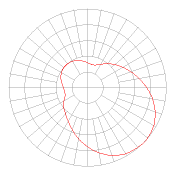 | ||||||||||||||||||
| Azimuth | Ratio | Azimuth | Ratio | Azimuth | Ratio | Azimuth | Ratio | ||||||||||||
| 0 | 0.315 | 10 | 0.297 | 13 | 0.296 | 20 | 0.304 | ||||||||||||
| 30 | 0.341 | 40 | 0.394 | 50 | 0.452 | 60 | 0.516 | ||||||||||||
| 70 | 0.586 | 80 | 0.664 | 90 | 0.750 | 100 | 0.838 | ||||||||||||
| 110 | 0.914 | 120 | 0.971 | 130 | 0.996 | 135 | 1.000 | ||||||||||||
| 140 | 0.992 | 150 | 0.970 | 160 | 0.918 | 170 | 0.841 | ||||||||||||
| 180 | 0.752 | 190 | 0.660 | 200 | 0.572 | 210 | 0.495 | ||||||||||||
| 220 | 0.436 | 230 | 0.395 | 240 | 0.345 | 250 | 0.303 | ||||||||||||
| 260 | 0.294 | 270 | 0.307 | 280 | 0.332 | 290 | 0.360 | ||||||||||||
| 300 | 0.381 | 310 | 0.392 | 315 | 0.393 | 320 | 0.392 | ||||||||||||
| 330 | 0.383 | 340 | 0.365 | 350 | 0.341 | ||||||||||||||
Structure Registration Number 1029536 Structure Type: TOWER Registered To: Nexstar Media Inc. Structure Address: 2.1 Km Nw Of Intersection Waianuenue & Akola Piihonua, HI County Name: Hawaii County ASR Issued: 05/28/2021 Date Built: 01/01/1967 Site Elevation: 262.7 m (862 ft.) Structure Height: 78.6 m (258 ft.) Height Overall: 79.6 m (261 ft.) Overall Height AMSL: 342.3 m (1123 ft.) Paint & Light FAA Chapters: 1, 3, 11, 21 19-42-49.0 N 155-08-03.0 W (NAD 83) 19-42-59.9 N 155-08-13.0 W (Converted to NAD 27) |
P.o. Box 6 Honolulu, HI 96810 Phone: 808-262-2000 Not-for-Profit | Date: 06/28/2006 Application Certifier LESEA BROADCASTING CORPORATION 61300 S. Ironwood Road South Bend, IN 46614 Applicant MARTIN W. HYLTON 61300 Ironwood Road South Bend, IN 46614 STAFF ENGINEER JOSEPH C. CHAUTIN, III Hardy, Carey, Chautin & Balkin, L.l.p. 110 Veterans Blvd Suite 300 Metairie, LA 70005 | |||||||||||||||||