
FCCInfo.com
A Service of Cavell, Mertz & Associates, Inc.
(855) FCC-INFO
|
|
KTVW-CD from 02/18/2002 KTVW-CD from 12/13/1996 KTVW-CD from 03/20/1992 |
Virtual Channel 6 |  |
|
||||||||||||||||||||||||
|
|
Repacking Information: No changes Status: License Application Accepted: 04/21/2014 License Expires: 10/01/2022 File Number: BLDTA-20140421ACI Prefix Type: This is BLDTA FCC Website Links: LMS Facility Details This Application Other KTVW-CD Applications Including Superseded Applications Mailing Address Correspondence for KTVW-CD Correspondence related to application BLDTA-20140421ACI Service Contour - Open Street Map or USGS Map (51 dBu) Service Contour - KML / Google Earth (51 dBu) Public Inspection Files Rabbit Ears Info Search for KTVW-CD Site Location: 34-58-05.8 N 111-30-36.1 W (NAD 83) Site Location: 34-58-05.7 N 111-30-33.6 W (Converted to NAD 27) ERP: 15 kW Electrical Beam Tilt: 1.25 degrees R/C AGL: 59 m (194 ft.) R/C AMSL: 2636 m (8648 ft.) Emission Mask: Stringent Site Elevation: 2577 m. (8455 ft.) Height Overall*: 81.4 m (267 ft.) (* As Filed In This Application, may differ from ASR Data, Below.) Directional Antenna - Antenna Make/Model: Electronics Research Inc. ALP12N-27 Antenna ID: 104035 | |||||||||||||||||||||||||||
| Antenna Data for Antenna Id: 104035 KTVW-CD DC File: BLDTA-20140421ACI Electronics Research Inc. - ALP12N-27 Service: DC Standard Pattern: Y Pattern and Field Values Include a 340° Clockwise Rotation | 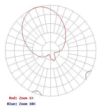 | |||||||||||||||||||||||||||
| Azimuth | Ratio | Azimuth | Ratio | Azimuth | Ratio | Azimuth | Ratio | |||||||||||||||||||||
| 0 | 0.906 | 10 | 0.815 | 20 | 0.713 | 30 | 0.611 | |||||||||||||||||||||
| 40 | 0.517 | 50 | 0.435 | 60 | 0.368 | 70 | 0.316 | |||||||||||||||||||||
| 80 | 0.269 | 90 | 0.221 | 100 | 0.168 | 110 | 0.120 | |||||||||||||||||||||
| 120 | 0.094 | 130 | 0.104 | 140 | 0.147 | 150 | 0.202 | |||||||||||||||||||||
| 160 | 0.236 | 170 | 0.202 | 180 | 0.147 | 190 | 0.104 | |||||||||||||||||||||
| 200 | 0.094 | 210 | 0.120 | 220 | 0.168 | 230 | 0.221 | |||||||||||||||||||||
| 240 | 0.269 | 250 | 0.316 | 260 | 0.368 | 270 | 0.435 | |||||||||||||||||||||
| 280 | 0.517 | 290 | 0.611 | 300 | 0.713 | 310 | 0.815 | |||||||||||||||||||||
| 320 | 0.906 | 330 | 0.972 | 340 | 1.000 | 350 | 0.972 | |||||||||||||||||||||
Structure Registration Number 1003841 Structure Type: Registered To: SBA Towers X, LLC Structure Address: Atop Mormon Mountain 3.5 Mi Se Mormon Lake, AZ County Name: Coconino County ASR Issued: 11/01/2021 Date Built: 12/19/1997 Site Elevation: 2577.1 m (8455 ft.) Structure Height: 79.2 m (260 ft.) Height Overall: 81.4 m (267 ft.) Overall Height AMSL: 2658.5 m (8722 ft.) FAA Determination: 11/07/2006 FAA Study #: 2006-awp-6268-OE Paint & Light FAA Chapters: NONE PRIOR STUDY 1990-AWP-863-OE 34-58-05.8 N 111-30-36.1 W (NAD 83) 34-58-05.7 N 111-30-33.6 W (Converted to NAD 27) |
101 Constitution Avenue, Nw, Suite 800w Washington, DC 20001 Phone: 310-348-3600 General Partnership | Date: 04/21/2014 Application Certifier KTVW LICENSE PARTNERSHIP, G.P. 5999 Center Drive Los Angeles, CA 90045 Applicant KARL D. LAHM, P.E. Univision Management Co. P.o. Box 647 Lake Villa, IL 60046 DIRECTOR, RF SYSTEMS ENGINEERING MACE J. ROSENSTEIN, ESQ. Covington & Burling Llp | ||||||||||||||||||||||||||
| ||||||||||||||||||||||||||||