
FCCInfo.com
A Service of Cavell, Mertz & Associates, Inc.
(855) FCC-INFO
|
|
W05CO-D from 01/17/2006 W05CO-D from 03/15/1993 W05CO-D from 03/11/1993 W05CO-D from 01/04/1989 |
|
|
||||||||||||||||
|
|
Status: License Application Accepted: 04/12/2005 License Expires: 02/01/2021 File Number: BLTVL-20050412AEI Prefix Type: This is a license for a VHF LPTV station FCC Website Links: LMS Facility Details This Application Other W05CO-D Applications Including Superseded Applications Mailing Address Correspondence for W05CO-D Correspondence related to application BLTVL-20050412AEI Service Contour - Open Street Map or USGS Map (62 dBu) Service Contour - KML / Google Earth (62 dBu) Rabbit Ears Info Search for W05CO-D Site Location: 27-20-11.0 N 82-28-18.0 W (NAD 83) Site Location: 27-20-09.8 N 82-28-18.7 W (Converted to NAD 27) ERP: 3 kW R/C AGL: 103 m (338 ft.) R/C AMSL: 112.1 m (368 ft.) Site Elevation: 9.1 m. (30 ft.) Height Overall*: 109.7 m (360 ft.) (* As Filed In This Application, may differ from ASR Data, Below.) Directional Antenna - Antenna Make/Model: Scala CA-2 Antenna ID: 59828 | ||||||||||||||||||
| Antenna Data for Antenna Id: 59828 W05CO-D TX File: BLTVL-20050412AEI Scala - CA-2 Service: TX Standard Pattern: Y | 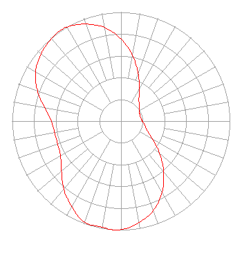 | ||||||||||||||||||
| Azimuth | Ratio | Azimuth | Ratio | Azimuth | Ratio | Azimuth | Ratio | ||||||||||||
| 0 | 0.753 | 10 | 0.610 | 20 | 0.463 | 30 | 0.334 | ||||||||||||
| 40 | 0.256 | 50 | 0.223 | 60 | 0.196 | 70 | 0.183 | ||||||||||||
| 80 | 0.183 | 90 | 0.196 | 100 | 0.223 | 110 | 0.256 | ||||||||||||
| 120 | 0.334 | 130 | 0.463 | 140 | 0.610 | 150 | 0.753 | ||||||||||||
| 160 | 0.871 | 170 | 0.947 | 180 | 0.996 | 185 | 1.000 | ||||||||||||
| 190 | 0.989 | 200 | 0.985 | 210 | 0.906 | 220 | 0.817 | ||||||||||||
| 230 | 0.713 | 240 | 0.641 | 250 | 0.619 | 260 | 0.619 | ||||||||||||
| 270 | 0.641 | 280 | 0.713 | 290 | 0.817 | 300 | 0.906 | ||||||||||||
| 310 | 0.958 | 320 | 0.989 | 325 | 1.000 | 330 | 0.996 | ||||||||||||
| 340 | 0.947 | 350 | 0.871 | ||||||||||||||||
Structure Registration Number 1030338 Structure Type: TOWER Registered To: PINNACLE TOWERS INC. Structure Address: 63 Christie Lane Sarasota, FL County Name: Sarasota County ASR Issued: 08/19/2000 Date Built: 06/01/1975 Site Elevation: 9.1 m (30 ft.) Structure Height: 103.6 m (340 ft.) Height Overall: 109.7 m (360 ft.) Overall Height AMSL: 118.8 m (390 ft.) FAA Determination: 01/15/1999 FAA Study #: 93-ASO-1429-OE FAA Circular #: 70/7460-1H Paint & Light FAA Chapters: 3, 4, 5, 13 PREV. 93-ASO-1492-OE 27-20-11.0 N 82-28-18.0 W (NAD 83) 27-20-09.8 N 82-28-18.7 W (Converted to NAD 27) |
Hurst, TX 76054 Phone: 214-770-7770 Corporation | Date: 04/12/2005 Application Certifier THREE ANGELS BROADCASTING NETWORK, INC. Po Box 220 3391 Charley Good Road West Frankfort, IL 62896 Applicant DAN PEEK 19384 Bobtail Road Benton, IL 62812-4836 CONSUTING ENGINEER MOSES PRIMO 3abn | |||||||||||||||||