
FCCInfo.com
A Service of Cavell, Mertz & Associates, Inc.
(855) FCC-INFO
|
|
|
Virtual Channel 36 |
|
||||||||||||||||
|
|
Repacking Information: No changes Status: License Application Accepted: 05/22/2009 License Expires: 06/01/2021 File Number: BLEDT-20090522AFW Prefix Type: This is a license for a noncommercial educational digital TV station FCC Website Links: LMS Facility Details This Application Other KKAP Applications Including Superseded Applications Mailing Address Correspondence for KKAP Correspondence related to application BLEDT-20090522AFW Service Contour - Open Street Map or USGS Map (41 dBu) Service Contour - KML / Google Earth (41 dBu) Public Inspection Files Rabbit Ears Info Search for KKAP Site Location: 34-47-56.0 N 92-29-45.0 W (NAD 83) Site Location: 34-47-55.7 N 92-29-44.4 W (Converted to NAD 27) ERP: 50 kW Polarization: Horizontally polarized HAAT: 394 m (1293 ft.) Electrical Beam Tilt: 0.75 degrees R/C AGL: 200 m (656 ft.) R/C AMSL: 521 m (1709 ft.) Site Elevation: 321 m. (1053 ft.) Height Overall*: 308 m (1010 ft.) (* As Filed In This Application, may differ from ASR Data, Below.) Directional Antenna - Antenna Make/Model: Systems With Reliability Inc. SWMP16PN Antenna ID: 85394 Polarization: Horizontally polarized | ||||||||||||||||||
| Antenna Data for Antenna Id: 85394 KKAP DT File: BLEDT-20090522AFW Systems With Reliability Inc. - SWMP16PN Service: DT Standard Pattern: Y | 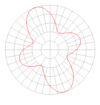 | ||||||||||||||||||
| Azimuth | Ratio | Azimuth | Ratio | Azimuth | Ratio | Azimuth | Ratio | ||||||||||||
| 0 | 0.810 | 10 | 0.630 | 20 | 0.460 | 30 | 0.430 | ||||||||||||
| 40 | 0.480 | 50 | 0.590 | 60 | 0.680 | 70 | 0.710 | ||||||||||||
| 80 | 0.680 | 90 | 0.590 | 100 | 0.480 | 110 | 0.410 | ||||||||||||
| 120 | 0.460 | 130 | 0.630 | 140 | 0.810 | 150 | 0.950 | ||||||||||||
| 160 | 1.000 | 170 | 0.950 | 180 | 0.810 | 190 | 0.630 | ||||||||||||
| 200 | 0.460 | 210 | 0.410 | 220 | 0.480 | 230 | 0.590 | ||||||||||||
| 240 | 0.680 | 250 | 0.710 | 260 | 0.680 | 270 | 0.590 | ||||||||||||
| 280 | 0.480 | 290 | 0.410 | 300 | 0.460 | 310 | 0.630 | ||||||||||||
| 320 | 0.810 | 330 | 0.950 | 340 | 1.000 | 350 | 0.950 | ||||||||||||
Structure Registration Number 1012584 Structure Type: TOWER Registered To: VB-S1 Assets, LLC Structure Address: 20324 Two Towers Rd Little Rock, AR County Name: Pulaski County ASR Issued: 04/01/2022 Date Built: 02/08/1988 Site Elevation: 320.9 m (1053 ft.) Structure Height: 308.4 m (1012 ft.) Height Overall: 308.4 m (1012 ft.) Overall Height AMSL: 629.3 m (2065 ft.) FAA Determination: 08/10/1987 FAA Study #: 87-ASW-0374-OE FAA Circular #: 70/7460-1G Paint & Light FAA Chapters: 4, 6, 9 34-47-56.0 N 92-29-45.0 W (NAD 83) 34-47-55.7 N 92-29-44.4 W (Converted to NAD 27) |
3901 Highway 121 South Bedford, TX 76021 Phone: 817-571-1229 Private Not-for-Profit Educational Institution | Date: 05/22/2009 Application Certifier EDUCATIONAL BROADCASTING CORPORATION 3901 Highway 121 South Bedford, TX 76021 Applicant RICHARD C GOETZ 135 N Country Club Dr Hendersonville, TN 37075 BROADCAST CONSULTANT ROBERT L. OLENDER Koerner & Olender, P.c. 11913 Grey Hollow Court North Bethesda, MD 20852 | |||||||||||||||||