
FCCInfo.com
A Service of Cavell, Mertz & Associates, Inc.
(855) FCC-INFO
|
|
K36BW-D from 09/12/2006 K36BW-D from 10/15/2004 K36BW-D from 12/15/1987 |
|
|
||||||||||||||||
|
|
Status: License Application Accepted: 10/18/2010 License Expires: 04/01/2022 File Number: BLDTL-20101018AAP Prefix Type: This is BLDTL FCC Website Links: LMS Facility Details This Application Other K36BW-D Applications Including Superseded Applications Mailing Address Correspondence for K36BW-D Correspondence related to application BLDTL-20101018AAP Service Contour - Open Street Map or USGS Map (51 dBu) Service Contour - KML / Google Earth (51 dBu) Rabbit Ears Info Search for K36BW-D Site Location: 47-32-27.0 N 115-19-05.0 W (NAD 83) Site Location: 47-32-27.2 N 115-19-01.5 W (Converted to NAD 27) ERP: 0.185 kW Electrical Beam Tilt: 3 degrees R/C AGL: 14 m (46 ft.) R/C AMSL: 1566 m (5138 ft.) Emission Mask: Simple Site Elevation: 1552 m. (5092 ft.) Height Overall*: 15.2 m (50 ft.) (* As Filed In This Application, may differ from ASR Data, Below.) Directional Antenna - Antenna Make/Model: Scala 4DR-4-2HW Antenna ID: 20741
| ||||||||||||||||||
| Antenna Data for Antenna Id: 20741 K36BW-D LD File: BLDTL-20101018AAP Scala - 4DR-4-2HW Service: LD Standard Pattern: Y Pattern and Field Values Include a 35° Clockwise Rotation | 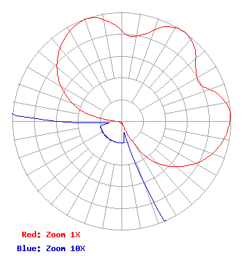 | ||||||||||||||||||
| Azimuth | Ratio | Azimuth | Ratio | Azimuth | Ratio | Azimuth | Ratio | ||||||||||||
| 5 | 0.784 | 15 | 0.827 | 25 | 0.955 | 35 | 1.000 | ||||||||||||
| 45 | 0.945 | 55 | 0.830 | 65 | 0.795 | 75 | 0.925 | ||||||||||||
| 85 | 0.995 | 95 | 0.975 | 105 | 0.920 | 115 | 0.835 | ||||||||||||
| 125 | 0.715 | 135 | 0.580 | 145 | 0.410 | 155 | 0.135 | ||||||||||||
| 165 | 0.020 | 175 | 0.020 | 185 | 0.020 | 195 | 0.020 | ||||||||||||
| 205 | 0.020 | 215 | 0.020 | 225 | 0.020 | 235 | 0.020 | ||||||||||||
| 245 | 0.020 | 255 | 0.020 | 265 | 0.020 | 275 | 0.130 | ||||||||||||
| 285 | 0.395 | 295 | 0.560 | 305 | 0.710 | 315 | 0.825 | ||||||||||||
| 325 | 0.915 | 335 | 0.975 | 345 | 0.983 | 355 | 0.895 | ||||||||||||
Structure Registration Number 1258591 [ASR Heights Differ from K36BW-D Application] Structure Type: GTOWER Registered To: Western Sanderson County TV District Structure Address: Clark Mtn. Thompson Falls, MT County Name: Sanders County ASR Issued: 12/16/2022 Date Built: 12/30/2006 Site Elevation: 1552 m (5092 ft.) Structure Height: 20 m (66 ft.) Height Overall: 20 m (66 ft.) Overall Height AMSL: 1572 m (5157 ft.) FAA Determination: 12/12/2022 FAA Study #: 2022-ANM-5364-OE Paint & Light FAA Chapters: NONE PRIOR STUDY 2007-ANM-1282-OE 47-32-27.0 N 115-19-05.0 W (NAD 83) 47-32-27.2 N 115-19-01.5 W (Converted to NAD 27) |
P.o. Box 519 Thompson Falls, MT 59873 Phone: 406-827-4100 Applicant | Date: 10/18/2010 Application Certifier THOMPSON FALLS TV DISTRICT P.o. Box 519 Thompson Falls, MT 59873 Applicant B. W. ST. CLAIR 2355 Ranch Drive Westminster, CO 80234 ENGINEERING CONSULTANT MR. ED THOMPSON Thompson Falls Tv District | |||||||||||||||||
| |||||||||||||||||||