
FCCInfo.com
A Service of Cavell, Mertz & Associates, Inc.
(855) FCC-INFO
|
|
KNRR from 11/16/1981 |
Virtual Channel 12 |
|
|||||||||||||||||||
|
|
Repacking Information: No changes Status: License Application Accepted: 10/16/2009 License Expires: 04/01/2014 File Number: BLCDT-20091016AAS Prefix Type: This is a License for a commercial digital TV station FCC Website Links: LMS Facility Details This Application Other KNRR Applications Including Superseded Applications Mailing Address Correspondence for KNRR Correspondence related to application BLCDT-20091016AAS Service Contour - Open Street Map or USGS Map (36 dBu) Service Contour - KML / Google Earth (36 dBu) Public Inspection Files History Cards for KNRR Rabbit Ears Info Search for KNRR Site Location: 48-59-44.0 N 97-24-29.0 W (NAD 83) Site Location: 48-59-44.0 N 97-24-27.7 W (Converted to NAD 27) ERP: 4.44 kW Polarization: Horizontally polarized HAAT: 427 m (1401 ft.) Electrical Beam Tilt: 0.5 degrees R/C AGL: 430.8 m (1413 ft.) R/C AMSL: 674 m (2211 ft.) Site Elevation: 243.2 m. (798 ft.) Height Overall*: 438.2 m (1438 ft.) (* As Filed In This Application, may differ from ASR Data, Below.) Directional Antenna - Antenna Make/Model: Bogner B8VAH Antenna ID: 89556 Polarization: Horizontally polarized | |||||||||||||||||||||
| Antenna Data for Antenna Id: 89556 KNRR DT File: BLCDT-20091016AAS Bogner - B8VAH Service: DT Standard Pattern: Y | 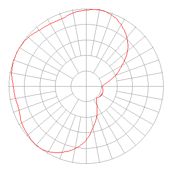 | |||||||||||||||||||||
| Azimuth | Ratio | Azimuth | Ratio | Azimuth | Ratio | Azimuth | Ratio | |||||||||||||||
| 0 | 0.980 | 10 | 1.000 | 20 | 0.975 | 30 | 0.910 | |||||||||||||||
| 40 | 0.820 | 50 | 0.700 | 60 | 0.540 | 70 | 0.410 | |||||||||||||||
| 80 | 0.280 | 90 | 0.210 | 100 | 0.220 | 110 | 0.230 | |||||||||||||||
| 120 | 0.230 | 130 | 0.220 | 140 | 0.210 | 150 | 0.280 | |||||||||||||||
| 160 | 0.410 | 170 | 0.540 | 180 | 0.700 | 190 | 0.820 | |||||||||||||||
| 200 | 0.910 | 210 | 0.975 | 220 | 1.000 | 230 | 0.980 | |||||||||||||||
| 240 | 0.960 | 250 | 0.920 | 260 | 0.925 | 270 | 0.940 | |||||||||||||||
| 280 | 0.975 | 290 | 0.990 | 300 | 0.990 | 310 | 0.975 | |||||||||||||||
| 320 | 0.940 | 330 | 0.925 | 340 | 0.920 | 350 | 0.960 | |||||||||||||||
Structure Registration Number 1048882 Structure Type: TOWER Registered To: SWI Funds Tower Holdings, LLC Structure Address: 12 Km Wnw Pembina, ND County Name: Pembina County ASR Issued: 01/22/2024 Date Built: 07/31/1987 Site Elevation: 243.2 m (798 ft.) Structure Height: 424.7 m (1393 ft.) Height Overall: 438.2 m (1438 ft.) Overall Height AMSL: 681.4 m (2236 ft.) FAA Determination: 04/10/1998 FAA Study #: 98-AGL-0551-OE Paint & Light FAA Chapters: A1, B, F, H HIGH INTENSITY STROBES. 48-59-44.0 N 97-24-29.0 W (NAD 83) 48-59-44.0 N 97-24-27.7 W (Converted to NAD 27) |
2750 Luberon Lane Cumming, GA 30041 Phone: 678-777-8659 Limited Liability Company | Date: 10/16/2009 Application Certifier RED RIVER BROADCAST CO., LLC P.o. Box 9115 Fargo, ND 58106 Applicant DONALD G. EVERIST Cohen, Dippell And Everist, P.c. 1300 L Street, Nw Suite 1100 Washington, DC 20005 CONSULTING ENGINEER CHARLES R. NAFTALIN Holland & Knight Llp 2099 Pennsylvania Avenue, N.w. Suite 100 Washington, DC 20006-6801 | ||||||||||||||||||||
| ||||||||||||||||||||||