
FCCInfo.com
A Service of Cavell, Mertz & Associates, Inc.
(855) FCC-INFO
|
|
KYVV-TV from 02/14/1992 |
Virtual Channel 10 |
|
||||||||||||||||
|
|
Status: Application Application Accepted: 10/08/2010 License Expires: 08/01/2022 File Number: BDRTCDT-20101008AAW Prefix Type: This is BDRTCDT FCC Website Links: LMS Facility Details This Application Other KYVV-TV Applications Including Superseded Applications Mailing Address Correspondence for KYVV-TV Correspondence related to application BDRTCDT-20101008AAW Service Contour - Open Street Map or USGS Map (51 dBu) Service Contour - KML / Google Earth (51 dBu) Rabbit Ears Info Search for KYVV-TV Site Location: 29-37-12.0 N 99-02-57.1 W (NAD 83) Site Location: 29-37-11.2 N 99-02-56.0 W (Converted to NAD 27) ERP: 14.99 kW Electrical Beam Tilt: 2 degrees R/C AGL: 430 m (1411 ft.) R/C AMSL: 901.5 m (2958 ft.) Emission Mask: Stringent Site Elevation: 471.5 m. (1547 ft.) Height Overall*: 457.5 m (1501 ft.) (* As Filed In This Application, may differ from ASR Data, Below.) Directional Antenna - Antenna Make/Model: Scala PRTV Antenna ID: 102469 | ||||||||||||||||||
| Antenna Data for Antenna Id: 102469 KYVV-TV LD File: BDRTCDT-20101008AAW Scala - PRTV Service: LD Standard Pattern: Y | 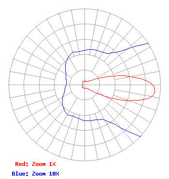 | ||||||||||||||||||
| Azimuth | Ratio | Azimuth | Ratio | Azimuth | Ratio | Azimuth | Ratio | ||||||||||||
| 0 | 0.045 | 10 | 0.047 | 20 | 0.048 | 30 | 0.049 | ||||||||||||
| 40 | 0.054 | 50 | 0.073 | 60 | 0.126 | 70 | 0.294 | ||||||||||||
| 80 | 0.613 | 90 | 0.895 | 100 | 0.895 | 110 | 0.613 | ||||||||||||
| 120 | 0.294 | 130 | 0.126 | 140 | 0.073 | 150 | 0.054 | ||||||||||||
| 160 | 0.049 | 170 | 0.048 | 180 | 0.047 | 190 | 0.045 | ||||||||||||
| 200 | 0.044 | 210 | 0.045 | 220 | 0.042 | 230 | 0.038 | ||||||||||||
| 240 | 0.033 | 250 | 0.028 | 260 | 0.026 | 270 | 0.024 | ||||||||||||
| 280 | 0.024 | 290 | 0.026 | 300 | 0.028 | 310 | 0.033 | ||||||||||||
| 320 | 0.038 | 330 | 0.042 | 340 | 0.045 | 350 | 0.044 | ||||||||||||
Structure Registration Number 1058179 Structure Type: GTOWER Registered To: American Towers, LLC Structure Address: 10416 State Highway 173 N (310168) Hondo, TX County Name: Medina County ASR Issued: 02/07/2020 Date Built: 04/15/1999 Site Elevation: 471.5 m (1547 ft.) Structure Height: 457.5 m (1501 ft.) Height Overall: 457.5 m (1501 ft.) Overall Height AMSL: 929 m (3048 ft.) FAA Determination: 06/18/2010 FAA Study #: 2010-ASW-2239-OE FAA Circular #: 70/7460-1J Paint & Light FAA Chapters: 4, 7, 13 PRIOR STUDY 2007-ASW-4548-OE 29-37-12.0 N 99-02-57.1 W (NAD 83) 29-37-11.2 N 99-02-56.0 W (Converted to NAD 27) |
Pobox 1756 Pacific Palisades, CA 90272 Phone: 310-573-1600 Limited Liability Company | Date: 10/08/2010 Application Certifier SATV10, LLC DEBTOR-IN-POSSESSION 10155 Collins Avenue Suite 1505 Bal Harbour, FL 33154 Applicant JIM MCPHETRIDGE 228 Flynn Drive El Paso, TX 79932 STATION ENGINEER ROBERT J. RINI, ESQ. Rini Coran, P.c. 1140 19th Street, N.w. Suite 600 Washington, DC 20036 | |||||||||||||||||