
FCCInfo.com
A Service of Cavell, Mertz & Associates, Inc.
(855) FCC-INFO
|
|
KUWB-LD from 06/11/2003 |
|
|
||||||||||||||||
|
|
Status: License Application Accepted: 07/14/2010 License Expires: 10/01/2022 File Number: BLDTT-20100714AAQ Prefix Type: This is BLDTT FCC Website Links: LMS Facility Details This Application Other KUWB-LD Applications Including Superseded Applications Mailing Address Correspondence for KUWB-LD Correspondence related to application BLDTT-20100714AAQ Service Contour - Open Street Map or USGS Map (51 dBu) Service Contour - KML / Google Earth (51 dBu) Rabbit Ears Info Search for KUWB-LD Site Location: 37-03-48.0 N 113-34-26.0 W (NAD 83) Site Location: 37-03-48.1 N 113-34-23.2 W (Converted to NAD 27) ERP: 0.13 kW R/C AGL: 18 m (59 ft.) R/C AMSL: 975.6 m (3201 ft.) Emission Mask: Stringent Site Elevation: 957.6 m. (3142 ft.) Height Overall*: 28.9 m (95 ft.) (* As Filed In This Application, may differ from ASR Data, Below.) Directional Antenna - Antenna Make/Model: Scala 2X3KBBU Antenna ID: 20728
| ||||||||||||||||||
| Antenna Data for Antenna Id: 20728 KUWB-LD LD File: BLDTT-20100714AAQ Scala - 2X3KBBU Service: LD Standard Pattern: Y | 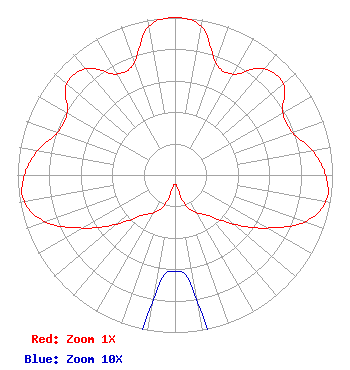 | ||||||||||||||||||
| Azimuth | Ratio | Azimuth | Ratio | Azimuth | Ratio | Azimuth | Ratio | ||||||||||||
| 0 | 1.000 | 10 | 0.958 | 20 | 0.757 | 30 | 0.740 | ||||||||||||
| 40 | 0.880 | 50 | 0.897 | 60 | 0.791 | 70 | 0.792 | ||||||||||||
| 80 | 0.886 | 90 | 0.957 | 100 | 0.973 | 110 | 0.873 | ||||||||||||
| 120 | 0.674 | 130 | 0.486 | 140 | 0.338 | 150 | 0.277 | ||||||||||||
| 160 | 0.212 | 170 | 0.082 | 180 | 0.061 | 190 | 0.082 | ||||||||||||
| 200 | 0.212 | 210 | 0.277 | 220 | 0.338 | 230 | 0.486 | ||||||||||||
| 240 | 0.674 | 250 | 0.873 | 260 | 0.973 | 270 | 0.957 | ||||||||||||
| 280 | 0.886 | 290 | 0.792 | 300 | 0.791 | 310 | 0.897 | ||||||||||||
| 320 | 0.880 | 330 | 0.740 | 340 | 0.757 | 350 | 0.958 | ||||||||||||
Structure Registration Number 1053312 [ASR Heights Differ from KUWB-LD Application] Structure Type: LTOWER Registered To: American Towers LLC Structure Address: Webb Hill - Washington County (#209530) St. George, UT County Name: Washington County ASR Issued: 03/21/2022 Date Built: 04/23/1999 Site Elevation: 951.9 m (3123 ft.) Structure Height: 27.4 m (90 ft.) Height Overall: 28.9 m (95 ft.) Overall Height AMSL: 980.8 m (3218 ft.) FAA Determination: 02/18/2022 FAA Study #: 2022-ANM-1248-OE Paint & Light FAA Chapters: NONE PRIOR STUDY 2021-ANM-4683-OE 37-03-49.3 N 113-34-25.7 W (NAD 83) 37-03-49.4 N 113-34-22.9 W (Converted to NAD 27) |
545 E. John Carpenter Freeway Suite 700 Irving, TX 75062 Phone: 972-373-8800 Corporation | Date: 07/14/2010 Application Certifier HIGH PLAINS BROADCASTING LICENSE COMPANY LLC P.o. Box 288 120 Oak Drive Kaw City, OK 74641 Applicant ROBERT LYON 2175 West 1700 South Salt Lake City, UT 84104-4200 CHIEF ENGINEER CLIFFORD M. HARRINGTON, ESQ. Pillsbury Winthrop Shaw Pittman Llp | |||||||||||||||||