
FCCInfo.com
A Service of Cavell, Mertz & Associates, Inc.
(855) FCC-INFO
|
|
|
Post-repack Channel 33 Virtual Channel 23 |
|
||||||||||||||||||||||
|
|
Repacking Information: Pre-Repack Channel: 40 Post-Repack Channel: 33 Post-Repack ERP: 370 kW Phase: 0 Completion Deadline: 6/1/2018 Find nearby TV Facilities Status: License Application Accepted: 11/20/2013 License Expires: 10/01/2021 File Number: BXLEDT-20131120ADM Prefix Type: This is BXLEDT FCC Website Links: LMS Facility Details This Application Other WKAR-TV Applications Including Superseded Applications Mailing Address Correspondence for WKAR-TV Correspondence related to application BXLEDT-20131120ADM Service Contour - Open Street Map or USGS Map (41 dBu) Service Contour - KML / Google Earth (41 dBu) Public Inspection Files History Cards for WKAR-TV Rabbit Ears Info Search for WKAR-TV Site Location: 42-42-06.9 N 84-24-47.8 W (NAD 83) Site Location: 42-42-06.8 N 84-24-47.9 W (Converted to NAD 27) ERP: 90 kW Polarization: Horizontally polarized HAAT: 145 m (476 ft.) Electrical Beam Tilt: 1 degree R/C AGL: 152.4 m (500 ft.) R/C AMSL: 411.5 m (1350 ft.) Site Elevation: 259.1 m. (850 ft.) Height Overall*: 313.3 m (1028 ft.) (* As Filed In This Application, may differ from ASR Data, Below.) Directional Antenna - Antenna Make/Model: DIELECTRIC TLP-16B-R Antenna ID: 105663 Polarization: Horizontally polarized | ||||||||||||||||||||||||
| Antenna Data for Antenna Id: 105663 WKAR-TV DX File: BXLEDT-20131120ADM DIELECTRIC - TLP-16B-R Service: DX Standard Pattern: Y | 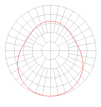 | ||||||||||||||||||||||||
| Azimuth | Ratio | Azimuth | Ratio | Azimuth | Ratio | Azimuth | Ratio | ||||||||||||||||||
| 0 | 0.645 | 10 | 0.641 | 20 | 0.631 | 30 | 0.613 | ||||||||||||||||||
| 40 | 0.592 | 50 | 0.579 | 60 | 0.570 | 70 | 0.579 | ||||||||||||||||||
| 80 | 0.610 | 90 | 0.650 | 100 | 0.699 | 110 | 0.759 | ||||||||||||||||||
| 120 | 0.817 | 130 | 0.869 | 140 | 0.914 | 150 | 0.951 | ||||||||||||||||||
| 160 | 0.975 | 170 | 0.993 | 180 | 1.000 | 190 | 0.996 | ||||||||||||||||||
| 200 | 0.981 | 210 | 0.955 | 220 | 0.920 | 230 | 0.876 | ||||||||||||||||||
| 240 | 0.826 | 250 | 0.771 | 260 | 0.714 | 270 | 0.661 | ||||||||||||||||||
| 280 | 0.615 | 290 | 0.583 | 300 | 0.569 | 310 | 0.571 | ||||||||||||||||||
| 320 | 0.586 | 330 | 0.607 | 340 | 0.627 | 350 | 0.640 | ||||||||||||||||||
Structure Registration Number 1265362 Structure Type: TOWER Registered To: Board of Trustees, Michigan State University Structure Address: 4101 Dobie Road Okemos, MI County Name: Ingham County ASR Issued: 12/22/2011 Date Built: 07/05/2011 Site Elevation: 259.1 m (850 ft.) Structure Height: 297.8 m (977 ft.) Height Overall: 313.3 m (1028 ft.) Overall Height AMSL: 572.4 m (1878 ft.) FAA Determination: 12/08/2011 FAA Study #: 2011-AGL-4543-OE FAA Circular #: 70/7460-1K Paint & Light FAA Chapters: 3, 4, 5, 12 OM&L to remain the same as prior study = PAINT/RED LIGHTS 42-42-06.9 N 84-24-47.8 W (NAD 83) 42-42-06.8 N 84-24-47.9 W (Converted to NAD 27) |
Wkar-am/fm/tv 404 Wilson Rd, Room 212 East Lansing, MI 48824 Phone: 517-884-4700 Private Not-for-Profit Educational Institution | Date: 11/20/2013 Application Certifier BOARD OF TRUSTEES, MICHIGAN STATE UNIVERSITY Wkar-am/fm/tv 404 Wilson Rd, Room 212 East Lansing, MI 48824-1212 Applicant BILL BEEKMAN 404 Wilson Rd. Room 212 East Lansing, MI 48824-1212 SECRETARY, BOARD OF TRUSTEES MALCOLM G. STEVENSON Schwartz, Woods & Miller | |||||||||||||||||||||||
| |||||||||||||||||||||||||