
FCCInfo.com
A Service of Cavell, Mertz & Associates, Inc.
(855) FCC-INFO
|
|
WUSV-LD from 09/22/2011 |
|
|
||||||||||||||||
|
|
Status: License Application Accepted: 06/16/2014 License Expires: 10/01/2020 File Number: BLDTL-20140616AEQ Prefix Type: This is BLDTL FCC Website Links: LMS Facility Details This Application Other WUSV-LD Applications Including Superseded Applications Mailing Address Correspondence for WUSV-LD Correspondence related to application BLDTL-20140616AEQ Service Contour - Open Street Map or USGS Map (51 dBu) Service Contour - KML / Google Earth (51 dBu) Rabbit Ears Info Search for WUSV-LD Site Location: 39-16-32.0 N 80-17-43.0 W (NAD 83) Site Location: 39-16-31.7 N 80-17-43.7 W (Converted to NAD 27) ERP: 0.27 kW R/C AGL: 15.3 m (50 ft.) R/C AMSL: 492.3 m (1615 ft.) Emission Mask: Stringent Site Elevation: 477 m. (1565 ft.) Height Overall*: 85.3 m (280 ft.) (* As Filed In This Application, may differ from ASR Data, Below.) Directional Antenna - Antenna Make/Model: Scala K723141 Antenna ID: 118603 | ||||||||||||||||||
| Antenna Data for Antenna Id: 118603 WUSV-LD LD File: BLDTL-20140616AEQ Scala - K723141 Service: LD Standard Pattern: Y Pattern and Field Values Include a 255° Clockwise Rotation | 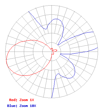 | ||||||||||||||||||
| Azimuth | Ratio | Azimuth | Ratio | Azimuth | Ratio | Azimuth | Ratio | ||||||||||||
| 5 | 0.070 | 15 | 0.070 | 25 | 0.060 | 35 | 0.040 | ||||||||||||
| 45 | 0.020 | 55 | 0.050 | 65 | 0.100 | 75 | 0.120 | ||||||||||||
| 85 | 0.100 | 95 | 0.050 | 105 | 0.020 | 115 | 0.040 | ||||||||||||
| 125 | 0.060 | 135 | 0.070 | 145 | 0.070 | 155 | 0.060 | ||||||||||||
| 165 | 0.050 | 175 | 0.070 | 185 | 0.150 | 195 | 0.270 | ||||||||||||
| 205 | 0.420 | 215 | 0.560 | 225 | 0.730 | 235 | 0.870 | ||||||||||||
| 245 | 0.960 | 255 | 1.000 | 265 | 0.960 | 275 | 0.870 | ||||||||||||
| 285 | 0.730 | 295 | 0.560 | 305 | 0.420 | 315 | 0.270 | ||||||||||||
| 325 | 0.150 | 335 | 0.070 | 345 | 0.050 | 355 | 0.060 | ||||||||||||
Structure Registration Number 1226149 Structure Type: Registered To: LLoyd Hoff Holding Corp. Structure Address: .4 Miles West Of Rt 50 & 179 Turn S On Gravel Rd Approx 4 Miles Clarksburg, WV County Name: Harrison County ASR Issued: 03/31/2022 Date Built: 01/05/1990 Site Elevation: 477 m (1565 ft.) Structure Height: 85.3 m (280 ft.) Height Overall: 85.3 m (280 ft.) Overall Height AMSL: 562.3 m (1845 ft.) FAA Determination: 11/01/1989 FAA Study #: 89-AEA-0099-OE Paint & Light FAA Chapters: 1, 3, 11, 21 RED LIGHTS/PAINT 39-16-32.0 N 80-17-43.0 W (NAD 83) 39-16-31.7 N 80-17-43.7 W (Converted to NAD 27) |
3038 Lansing Edmond Road Edmond, WV 25837 Phone: 304-222-5062 Corporation | Date: 06/16/2014 Application Certifier STEVEN J. TOCCO 392 Buccaneer Drive Largo, FL 33770 Applicant STEVE TOCCO 392 Buccaneer Drive Largo, FL 33770 PERMITEE STEVEN J. TOCCO | |||||||||||||||||