
FCCInfo.com
A Service of Cavell, Mertz & Associates, Inc.
(855) FCC-INFO
|
|
K20DD-D from 11/01/1990 |
|
|
||||||||||||||||
|
|
Status: License Application Accepted: 05/24/2012 License Expires: 02/01/2023 File Number: BLDTL-20120524AIN Prefix Type: This is BLDTL FCC Website Links: LMS Facility Details This Application Other K20DD-D Applications Including Superseded Applications Mailing Address Correspondence for K20DD-D Correspondence related to application BLDTL-20120524AIN Service Contour - Open Street Map or USGS Map (51 dBu) Service Contour - KML / Google Earth (51 dBu) Rabbit Ears Info Search for K20DD-D Site Location: 44-30-16.9 N 122-57-36.0 W (NAD 83) Site Location: 44-30-17.5 N 122-57-31.7 W (Converted to NAD 27) ERP: 2 kW R/C AGL: 21 m (69 ft.) R/C AMSL: 454.4 m (1491 ft.) Emission Mask: Simple Site Elevation: 433.4 m. (1422 ft.) Height Overall*: 61 m (200 ft.) (* As Filed In This Application, may differ from ASR Data, Below.) Directional Antenna - Antenna Make/Model: Jampro JA/LS-CE-8 Antenna ID: 19445
| ||||||||||||||||||
| Antenna Data for Antenna Id: 19445 K20DD-D LD File: BLDTL-20120524AIN Jampro - JA/LS-CE-8 Service: LD Standard Pattern: Y Pattern and Field Values Include a 300° Clockwise Rotation | 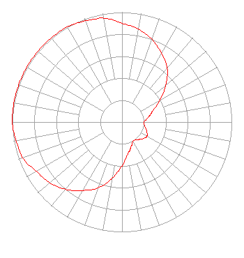 | ||||||||||||||||||
| Azimuth | Ratio | Azimuth | Ratio | Azimuth | Ratio | Azimuth | Ratio | ||||||||||||
| 0 | 0.900 | 10 | 0.860 | 20 | 0.800 | 30 | 0.720 | ||||||||||||
| 40 | 0.640 | 50 | 0.520 | 60 | 0.400 | 70 | 0.300 | ||||||||||||
| 75 | 0.270 | 80 | 0.240 | 90 | 0.200 | 100 | 0.210 | ||||||||||||
| 110 | 0.240 | 120 | 0.260 | 130 | 0.240 | 140 | 0.210 | ||||||||||||
| 150 | 0.200 | 160 | 0.240 | 165 | 0.270 | 170 | 0.300 | ||||||||||||
| 180 | 0.400 | 190 | 0.520 | 200 | 0.640 | 210 | 0.720 | ||||||||||||
| 220 | 0.800 | 230 | 0.860 | 240 | 0.900 | 250 | 0.960 | ||||||||||||
| 255 | 0.970 | 260 | 0.980 | 270 | 1.000 | 280 | 1.000 | ||||||||||||
| 290 | 1.000 | 300 | 1.000 | 310 | 1.000 | 320 | 1.000 | ||||||||||||
| 330 | 1.000 | 340 | 0.980 | 345 | 0.970 | 350 | 0.960 | ||||||||||||
Structure Registration Number 1034282 [ASR Heights Differ from K20DD-D Application] Structure Type: LTOWER Registered To: American Towers LLC Structure Address: 35701 Rock Hill Road (peterson Butte #8222) Lebanon, OR County Name: Linn County ASR Issued: 07/03/2013 Date Built: 03/01/1993 Site Elevation: 431.6 m (1416 ft.) Structure Height: 61.3 m (201 ft.) Height Overall: 65.8 m (216 ft.) Overall Height AMSL: 497.4 m (1632 ft.) FAA Determination: 06/24/2013 FAA Study #: 2013-ANM-1357-OE FAA Circular #: 70/7460-1K Paint & Light FAA Chapters: 4, 6, 12 PRIOR STUDY 2006-ANM-3993-OE 44-30-16.9 N 122-57-36.0 W (NAD 83) 44-30-17.5 N 122-57-31.7 W (Converted to NAD 27) |
4370 Peachtree Road, Ne Atlanta, GA 30319 Phone: 404-266-3888 Limited Liability Company | Date: 05/24/2012 Application Certifier MEREDITH CORPORATION Television Station Kpdx(tv) 1716 Locust Street Des Moines, IA 50309-3203 Applicant JOSEPH L. SNELSON, JR. C/o Kvvu, 25 Tv5 Drive Henderson, NV 89014 VP OF ENGINEERING ROBERT J. FOLLIARD, III Dow Lohnes Pllc | |||||||||||||||||