
FCCInfo.com
A Service of Cavell, Mertz & Associates, Inc.
(855) FCC-INFO
|
|
KAAS-LP from 10/26/1994 |
|
|
||||||||||||||||
|
|
Status: License Application Accepted: 01/06/2014 License Expires: 06/01/2014 File Number: BLDTL-20140106DNZ Prefix Type: This is BLDTL FCC Website Links: LMS Facility Details This Application Other KAAS-LP Applications Including Superseded Applications Mailing Address Correspondence for KAAS-LP Correspondence related to application BLDTL-20140106DNZ Service Contour - Open Street Map or USGS Map (51 dBu) Service Contour - KML / Google Earth (51 dBu) Rabbit Ears Info Search for KAAS-LP Site Location: 37-52-26.9 N 100-50-47.4 W (NAD 83) Site Location: 37-52-26.8 N 100-50-45.8 W (Converted to NAD 27) ERP: 8.2 kW R/C AGL: 130 m (427 ft.) R/C AMSL: 1020 m (3346 ft.) Emission Mask: Stringent Site Elevation: 890 m. (2920 ft.) Height Overall*: 136.9 m (449 ft.) (* As Filed In This Application, may differ from ASR Data, Below.) Directional Antenna - Antenna Make/Model: Systems With Reliability Inc. SWLP24OI Antenna ID: 24182 | ||||||||||||||||||
| Antenna Data for Antenna Id: 24182 KAAS-LP LD File: BLDTL-20140106DNZ Systems With Reliability Inc. - SWLP24OI Service: LD Standard Pattern: Y | 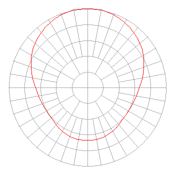 | ||||||||||||||||||
| Azimuth | Ratio | Azimuth | Ratio | Azimuth | Ratio | Azimuth | Ratio | ||||||||||||
| 0 | 1.000 | 10 | 1.000 | 20 | 0.980 | 30 | 0.950 | ||||||||||||
| 40 | 0.910 | 50 | 0.870 | 60 | 0.820 | 70 | 0.760 | ||||||||||||
| 80 | 0.710 | 90 | 0.660 | 100 | 0.630 | 110 | 0.610 | ||||||||||||
| 120 | 0.600 | 130 | 0.600 | 140 | 0.620 | 150 | 0.640 | ||||||||||||
| 160 | 0.660 | 170 | 0.670 | 180 | 0.670 | 190 | 0.670 | ||||||||||||
| 200 | 0.660 | 210 | 0.640 | 220 | 0.620 | 230 | 0.600 | ||||||||||||
| 240 | 0.600 | 250 | 0.610 | 260 | 0.630 | 270 | 0.660 | ||||||||||||
| 280 | 0.710 | 290 | 0.760 | 300 | 0.820 | 310 | 0.870 | ||||||||||||
| 320 | 0.910 | 330 | 0.950 | 340 | 0.980 | 350 | 1.000 | ||||||||||||
Structure Registration Number 1031172 Structure Type: GTOWER Registered To: American Towers LLC Structure Address: Hwy 83, 6.5 Mi S Of Garden City, KS County Name: Finney County ASR Issued: 01/05/2021 Date Built: 01/01/1967 Site Elevation: 890 m (2920 ft.) Structure Height: 135.9 m (446 ft.) Height Overall: 136.9 m (449 ft.) Overall Height AMSL: 1026.9 m (3369 ft.) FAA Determination: 09/17/2020 FAA Study #: 2020-ACE-6025-OE FAA Circular #: 70/7460-1L Paint & Light FAA Chapters: 4, 8, 12 37-52-26.9 N 100-50-47.4 W (NAD 83) 37-52-26.8 N 100-50-45.8 W (Converted to NAD 27) |
C/o Miles S. Mason, Esq. - Pillsbury Winthrop 1200 Seventeenth Street, Nw Washington, DC 20036 Phone: 202-663-8195 Applicant | Date: 01/06/2014 Application Certifier KSAS LICENSEE, LLC C/o Clifford Harrington, Pillsbury Winth 2300 N Street, Nw Washington, DC 20037 Applicant HARVEY ARNOLD 10706 Beaver Dam Road Hunt Valley, MD 21030 DIRECTOR OF ENGINEERING CLIFFORD M. HARRINGTON, ESQ. Pillsbury Winthrop Shaw Pittman Llp | |||||||||||||||||