
FCCInfo.com
A Service of Cavell, Mertz & Associates, Inc.
(855) FCC-INFO
|
|
KZFW-LD from 04/02/2007 KZFW-LD from 02/01/1995 KZFW-LD from 02/19/1993 KZFW-LD from 07/27/1984 |
|
|
||||||||||||||||
|
|
Status: Construction Permit Application Accepted: 01/21/2014 KZFW-LD CP Expires: 08/01/2022 File Number: BPTVL-20140121ABD Prefix Type: This is a construction permit for a VHF LPTV station FCC Website Links: LMS Facility Details This Application Other KZFW-LD Applications Including Superseded Applications Mailing Address Correspondence for KZFW-LD Correspondence related to application BPTVL-20140121ABD Service Contour - Open Street Map or USGS Map (62 dBu) Service Contour - KML / Google Earth (62 dBu) Rabbit Ears Info Search for KZFW-LD Site Location: 32-35-02.7 N 96-57-48.8 W (NAD 83) Site Location: 32-35-02.2 N 96-57-47.8 W (Converted to NAD 27) ERP: 3 kW R/C AGL: 440 m (1444 ft.) R/C AMSL: 0 m Site Elevation: 249.3 m. (818 ft.) Height Overall*: 527.6 m (1731 ft.) (* As Filed In This Application, may differ from ASR Data, Below.) Directional Antenna - Antenna Make/Model: Scala CL-26 Antenna ID: 117779 | ||||||||||||||||||
| Antenna Data for Antenna Id: 117779 KZFW-LD TX File: BPTVL-20140121ABD Scala - CL-26 Service: TX Standard Pattern: Y Pattern and Field Values Include a 45° Clockwise Rotation | 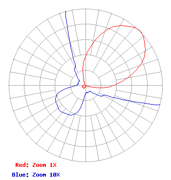 | ||||||||||||||||||
| Azimuth | Ratio | Azimuth | Ratio | Azimuth | Ratio | Azimuth | Ratio | ||||||||||||
| 5 | 0.460 | 15 | 0.655 | 25 | 0.835 | 35 | 0.940 | ||||||||||||
| 45 | 1.000 | 55 | 0.940 | 65 | 0.835 | 75 | 0.655 | ||||||||||||
| 85 | 0.460 | 95 | 0.295 | 105 | 0.105 | 115 | 0.035 | ||||||||||||
| 125 | 0.025 | 135 | 0.015 | 145 | 0.010 | 155 | 0.010 | ||||||||||||
| 165 | 0.010 | 175 | 0.010 | 185 | 0.015 | 195 | 0.035 | ||||||||||||
| 205 | 0.043 | 215 | 0.045 | 225 | 0.047 | 235 | 0.045 | ||||||||||||
| 245 | 0.043 | 255 | 0.035 | 265 | 0.015 | 275 | 0.010 | ||||||||||||
| 285 | 0.010 | 295 | 0.010 | 305 | 0.010 | 315 | 0.015 | ||||||||||||
| 325 | 0.025 | 335 | 0.035 | 345 | 0.105 | 355 | 0.295 | ||||||||||||
Structure Registration Number 1053452 Structure Type: TOWER Registered To: American Towers LLC Structure Address: 501 S Potter St Cedar Hill, TX County Name: Dallas County ASR Issued: 04/14/2014 Date Built: 07/16/2004 Site Elevation: 249.3 m (818 ft.) Structure Height: 527.6 m (1731 ft.) Height Overall: 527.6 m (1731 ft.) Overall Height AMSL: 776.9 m (2549 ft.) FAA Determination: 08/30/2004 FAA Study #: 2004-ASW-3977-OE FAA Circular #: 70/7460-1K Paint & Light FAA Chapters: 4, 9, 12 PRIOR STUDY 2002-ASW-4481-OE 32-35-02.7 N 96-57-48.8 W (NAD 83) 32-35-02.2 N 96-57-47.8 W (Converted to NAD 27) |
1901 E. Centerville Rd. Garland, TX 75042 Phone: 972-487-1371 Not-for-Profit | Date: 01/21/2014 Application Certifier DFW BROADCASTING, INC 13111 N. Central Expressway Dallas,, TX 75243 Applicant GARY L. GRAHAM Po Box 3030 Weatherford, TX 76086 TECHNICAL CONSULTANT GARY GRAHAM Gary Graham Broadcast Engineering P.o. Box 3030 Weatherford, TX 76086 | |||||||||||||||||