
FCCInfo.com
A Service of Cavell, Mertz & Associates, Inc.
(855) FCC-INFO
|
|
KUOK-CD from 08/02/2011 KUOK-CD from 04/09/2010 KUOK-CD from 11/21/1997 KUOK-CD from 07/09/1997 KUOK-CD from 07/14/1997 KUOK-CD from 11/21/1991 |
|
|
||||||||||||||||
|
|
Repacking Information: No changes Status: License Application Accepted: 01/28/2011 License Expires: 06/01/2022 File Number: BLDTA-20110128AAA Prefix Type: This is BLDTA FCC Website Links: LMS Facility Details This Application Other KUOK-CD Applications Including Superseded Applications Mailing Address Correspondence for KUOK-CD Correspondence related to application BLDTA-20110128AAA Service Contour - Open Street Map or USGS Map (51 dBu) Service Contour - KML / Google Earth (51 dBu) Public Inspection Files Rabbit Ears Info Search for KUOK-CD Site Location: 35-24-54.0 N 97-30-37.0 W (NAD 83) Site Location: 35-24-53.8 N 97-30-35.9 W (Converted to NAD 27) ERP: 7.33 kW Electrical Beam Tilt: 0.75 degrees R/C AGL: 168.9 m (554 ft.) R/C AMSL: 540.7 m (1774 ft.) Emission Mask: Stringent Site Elevation: 371.8 m. (1220 ft.) Height Overall*: 188.9 m (620 ft.) (* As Filed In This Application, may differ from ASR Data, Below.) Directional Antenna - Antenna Make/Model: Systems With Reliability Inc. SWLP16OI/36 Antenna ID: 101224 | ||||||||||||||||||
| Antenna Data for Antenna Id: 101224 KUOK-CD DC File: BLDTA-20110128AAA Systems With Reliability Inc. - SWLP16OI/36 Service: DC Standard Pattern: Y | 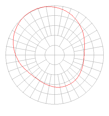 | ||||||||||||||||||
| Azimuth | Ratio | Azimuth | Ratio | Azimuth | Ratio | Azimuth | Ratio | ||||||||||||
| 0 | 0.965 | 10 | 0.935 | 20 | 0.895 | 30 | 0.845 | ||||||||||||
| 40 | 0.795 | 50 | 0.745 | 60 | 0.695 | 70 | 0.650 | ||||||||||||
| 80 | 0.620 | 90 | 0.605 | 100 | 0.605 | 110 | 0.615 | ||||||||||||
| 120 | 0.630 | 130 | 0.650 | 140 | 0.665 | 150 | 0.670 | ||||||||||||
| 160 | 0.670 | 170 | 0.665 | 180 | 0.650 | 190 | 0.630 | ||||||||||||
| 200 | 0.615 | 210 | 0.605 | 220 | 0.605 | 230 | 0.620 | ||||||||||||
| 240 | 0.650 | 250 | 0.695 | 260 | 0.745 | 270 | 0.795 | ||||||||||||
| 280 | 0.845 | 290 | 0.895 | 300 | 0.935 | 310 | 0.965 | ||||||||||||
| 320 | 0.990 | 330 | 1.000 | 340 | 1.000 | 350 | 0.990 | ||||||||||||
Structure Registration Number 1010023 Structure Type: GTOWER Registered To: Tyler Enterpirses L.L.C. Structure Address: 5005 S Shields Blvd Oklahoma City, OK County Name: Oklahoma County ASR Issued: 06/05/2019 Date Built: 06/27/2017 Site Elevation: 371.8 m (1220 ft.) Structure Height: 182.8 m (600 ft.) Height Overall: 188.9 m (620 ft.) Overall Height AMSL: 560.7 m (1840 ft.) FAA Determination: 10/06/2016 FAA Study #: 2016-ASW-4406-OE FAA Circular #: 70/7460-1L Paint & Light FAA Chapters: 3, 4, 5, 12 PRIOR STUDY 1987-ASW-33-OE 35-24-54.2 N 97-30-38.1 W (NAD 83) 35-24-54.0 N 97-30-37.0 W (Converted to NAD 27) |
5101 S. Shields Blvd. Oklahoma City, OK 73129 Phone: 405-616-5500 Limited Liability Company | Date: 01/28/2011 Application Certifier OKLAHOMA LAND COMPANY, LLC 5101 South Shields Boulevard Oklahoma City, OK 73129 Applicant RANDALL MULLINAX 5101 S. Shields Blvd. Oklahoma City, OK 73129 CHIEF ENGINEER JOHN C. TRENT, ESQUIRE Putbrese Hunsaker & Trent, P.c. | |||||||||||||||||