
FCCInfo.com
A Service of Cavell, Mertz & Associates, Inc.
(855) FCC-INFO
|
|
K32GW-D from 04/20/1982 |
|
|
||||||||||||||||
|
|
Status: License Application Accepted: 05/29/2007 License Expires: 10/01/2022 File Number: BLDTT-20070529ADO Prefix Type: This is BLDTT FCC Website Links: LMS Facility Details This Application Other K32GW-D Applications Including Superseded Applications Mailing Address Correspondence for K32GW-D Correspondence related to application BLDTT-20070529ADO Service Contour - Open Street Map or USGS Map (51 dBu) Service Contour - KML / Google Earth (51 dBu) Rabbit Ears Info Search for K32GW-D Site Location: 39-15-34.0 N 119-42-20.0 W (NAD 83) Site Location: 39-15-34.3 N 119-42-16.4 W (Converted to NAD 27) ERP: 6.94 kW R/C AGL: 18.3 m (60 ft.) R/C AMSL: 2286.3 m (7501 ft.) Emission Mask: Stringent Site Elevation: 2268 m. (7441 ft.) Height Overall*: 81 m (266 ft.) (* As Filed In This Application, may differ from ASR Data, Below.) Directional Antenna - Antenna Make/Model: Antenna Concepts Inc. ACS8B Antenna ID: 17790
| ||||||||||||||||||
| Antenna Data for Antenna Id: 17790 K32GW-D LD File: BLDTT-20070529ADO Antenna Concepts Inc. - ACS8B Service: LD Standard Pattern: Y Pattern and Field Values Include a 140° Clockwise Rotation | 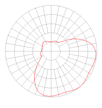 | ||||||||||||||||||
| Azimuth | Ratio | Azimuth | Ratio | Azimuth | Ratio | Azimuth | Ratio | ||||||||||||
| 0 | 0.200 | 10 | 0.210 | 20 | 0.230 | 30 | 0.240 | ||||||||||||
| 40 | 0.240 | 50 | 0.330 | 60 | 0.520 | 70 | 0.720 | ||||||||||||
| 80 | 0.890 | 90 | 0.970 | 100 | 0.980 | 110 | 0.960 | ||||||||||||
| 120 | 0.950 | 130 | 0.980 | 140 | 1.000 | 150 | 0.980 | ||||||||||||
| 160 | 0.950 | 170 | 0.960 | 180 | 0.980 | 190 | 0.970 | ||||||||||||
| 200 | 0.890 | 210 | 0.720 | 220 | 0.520 | 230 | 0.330 | ||||||||||||
| 240 | 0.240 | 250 | 0.240 | 260 | 0.230 | 270 | 0.210 | ||||||||||||
| 280 | 0.200 | 290 | 0.210 | 300 | 0.220 | 310 | 0.240 | ||||||||||||
| 320 | 0.250 | 330 | 0.240 | 340 | 0.220 | 350 | 0.210 | ||||||||||||
Structure Registration Number 1009893 Structure Type: TOWER Registered To: American Towers LLC Structure Address: Mc Clellan Peak Carson City, NV County Name: Washoe County ASR Issued: 01/05/2021 Date Built: 07/18/1994 Site Elevation: 2267.7 m (7440 ft.) Structure Height: 79.2 m (260 ft.) Height Overall: 80.7 m (265 ft.) Overall Height AMSL: 2348.4 m (7705 ft.) FAA Determination: 08/19/1994 FAA Study #: 94-AWP-1139-OE FAA Circular #: 70/7460-1H Paint & Light FAA Chapters: 4, 6, 13 39-15-34.0 N 119-42-20.0 W (NAD 83) 39-15-34.3 N 119-42-16.4 W (Converted to NAD 27) |
Avon, CO 81620 Phone: 435-649-0045 Applicant | Date: 05/29/2007 Application Certifier ELLIS COMMUNICATIONS, INC. 1180 Northmoor Court Atlanta, GA 30327 Applicant B. W. ST. CLAIR 2355 Ranch Drive Westminster, CO 80234 ENGINEERING CONSULTANT JOSEPH A. GODLES, ESQ. Goldberg Godles Wiener & Wright | |||||||||||||||||