
FCCInfo.com
A Service of Cavell, Mertz & Associates, Inc.
(855) FCC-INFO
|
|
K12NH-D from 06/26/1985 |
|
|
||||||||||||||||
|
|
Status: License Application Accepted: 11/14/2011 License Expires: 10/01/2022 File Number: BLDTV-20111114BCD Prefix Type: This is BLDTV FCC Website Links: LMS Facility Details This Application Other K12NH-D Applications Including Superseded Applications Mailing Address Correspondence for K12NH-D Correspondence related to application BLDTV-20111114BCD Service Contour - Open Street Map or USGS Map (48 dBu) Service Contour - KML / Google Earth (48 dBu) Rabbit Ears Info Search for K12NH-D Site Location: 32-47-12.5 N 103-07-05.0 W (NAD 83) Site Location: 32-47-12.1 N 103-07-03.2 W (Converted to NAD 27) ERP: 0.3 kW R/C AGL: 91 m (299 ft.) R/C AMSL: 1207 m (3960 ft.) Emission Mask: Simple Site Elevation: 1116 m. (3661 ft.) Height Overall*: 134 m (440 ft.) (* As Filed In This Application, may differ from ASR Data, Below.) Directional Antenna - Antenna Make/Model: Scala DRV-1/2HW Antenna ID: 105641
| ||||||||||||||||||
| Antenna Data for Antenna Id: 105641 K12NH-D LD File: BLDTV-20111114BCD Scala - DRV-1/2HW Service: LD Standard Pattern: Y | 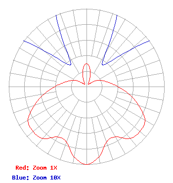 | ||||||||||||||||||
| Azimuth | Ratio | Azimuth | Ratio | Azimuth | Ratio | Azimuth | Ratio | ||||||||||||
| 0 | 0.294 | 10 | 0.239 | 20 | 0.134 | 30 | 0.048 | ||||||||||||
| 40 | 0.037 | 50 | 0.073 | 60 | 0.153 | 70 | 0.220 | ||||||||||||
| 80 | 0.295 | 90 | 0.402 | 100 | 0.554 | 110 | 0.713 | ||||||||||||
| 120 | 0.867 | 130 | 0.898 | 140 | 0.869 | 150 | 0.746 | ||||||||||||
| 160 | 0.756 | 170 | 0.917 | 180 | 1.000 | 190 | 0.917 | ||||||||||||
| 200 | 0.756 | 210 | 0.746 | 220 | 0.869 | 230 | 0.898 | ||||||||||||
| 240 | 0.867 | 250 | 0.713 | 260 | 0.554 | 270 | 0.402 | ||||||||||||
| 280 | 0.295 | 290 | 0.220 | 300 | 0.153 | 310 | 0.073 | ||||||||||||
| 320 | 0.037 | 330 | 0.048 | 340 | 0.134 | 350 | 0.239 | ||||||||||||
Structure Registration Number 1002832 [ASR Heights Differ from K12NH-D Application] Structure Type: GTOWER Registered To: American Towers LLC Structure Address: 7520 Casa Bonita (#208264) Hobbs, NM County Name: Lea County ASR Issued: 10/14/2021 Date Built: 01/01/1989 Site Elevation: 1117.4 m (3666 ft.) Structure Height: 133.5 m (438 ft.) Height Overall: 135 m (443 ft.) Overall Height AMSL: 1252.4 m (4109 ft.) FAA Determination: 10/12/2021 FAA Study #: 2021-ASW-11355-OE FAA Circular #: 70/7460-1M Paint & Light FAA Chapters: 4, 8, 15 PRIOR STUDY 2013-ASW-2510-OE 32-47-12.5 N 103-07-05.0 W (NAD 83) 32-47-12.1 N 103-07-03.2 W (Converted to NAD 27) |
C/o Brooks, Pierce Et Al. P.o. Box 1800 Raleigh, NC 27602 Phone: 919-839-0300 Corporation | Date: 11/14/2011 Application Certifier KOAT HEARST TELEVISION INC. C/o Brooks, Pierce, Et Al. Po Box 1800 Raleigh, NC 27602 Applicant BENJAMIN L. PIDEK, P.E. John F.x. Browne & Associates P.o. Box 1090 Bloomfield Hills, MI 48303 CONSULTING ENGINEER MARK J. PRAK Brooks, Pierce, Et Al. | |||||||||||||||||