
FCCInfo.com
A Service of Cavell, Mertz & Associates, Inc.
(855) FCC-INFO
|
|
K47JK-D from 12/07/2004 |
|
|
||||||||||||||||
|
|
Status: License (Licensed And Silent) Application Accepted: 12/05/2007 License Expires: 10/01/2022 File Number: BLDTL-20071205AAV Prefix Type: This is BLDTL FCC Website Links: LMS Facility Details This Application Other K47JK-D Applications Including Superseded Applications Mailing Address Correspondence for K47JK-D Correspondence related to application BLDTL-20071205AAV Service Contour - Open Street Map or USGS Map (51 dBu) Service Contour - KML / Google Earth (51 dBu) Rabbit Ears Info Search for K47JK-D Site Location: 42-51-50.1 N 112-31-13.3 W (NAD 83) Site Location: 42-51-50.4 N 112-31-10.4 W (Converted to NAD 27) ERP: 15 kW R/C AGL: 66 m (217 ft.) R/C AMSL: 1836 m (6024 ft.) Emission Mask: Stringent Site Elevation: 1770 m. (5807 ft.) Height Overall*: 92.4 m (303 ft.) (* As Filed In This Application, may differ from ASR Data, Below.) Directional Antenna - Antenna Make/Model: Jampro JA/LS-DB-8 Antenna ID: 19470 | ||||||||||||||||||
| Antenna Data for Antenna Id: 19470 K47JK-D LD File: BLDTL-20071205AAV Jampro - JA/LS-DB-8 Service: LD Standard Pattern: Y Pattern and Field Values Include a 30° Clockwise Rotation | 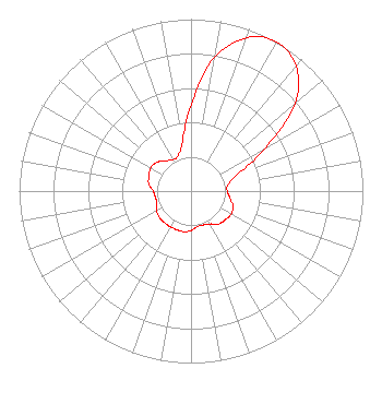 | ||||||||||||||||||
| Azimuth | Ratio | Azimuth | Ratio | Azimuth | Ratio | Azimuth | Ratio | ||||||||||||
| 0 | 0.500 | 10 | 0.790 | 20 | 0.950 | 30 | 1.000 | ||||||||||||
| 40 | 0.950 | 50 | 0.790 | 60 | 0.500 | 70 | 0.290 | ||||||||||||
| 80 | 0.220 | 90 | 0.210 | 100 | 0.230 | 110 | 0.260 | ||||||||||||
| 120 | 0.270 | 130 | 0.260 | 140 | 0.250 | 150 | 0.220 | ||||||||||||
| 160 | 0.210 | 170 | 0.210 | 180 | 0.230 | 190 | 0.240 | ||||||||||||
| 200 | 0.240 | 210 | 0.240 | 220 | 0.240 | 230 | 0.240 | ||||||||||||
| 240 | 0.230 | 250 | 0.210 | 260 | 0.210 | 270 | 0.220 | ||||||||||||
| 280 | 0.250 | 290 | 0.260 | 300 | 0.270 | 310 | 0.260 | ||||||||||||
| 320 | 0.230 | 330 | 0.210 | 340 | 0.220 | 350 | 0.290 | ||||||||||||
Structure Registration Number 1239956 [ASR Heights Differ from K47JK-D Application] Structure Type: TOWER Registered To: MM Shirin Properties, LLC Structure Address: Howard Mt. Lot 12, Power County Pocatello, ID County Name: Power County ASR Issued: 03/12/2019 Date Built: 11/06/2003 Site Elevation: 1770.6 m (5809 ft.) Structure Height: 91.4 m (300 ft.) Height Overall: 92.4 m (303 ft.) Overall Height AMSL: 1863 m (6112 ft.) FAA Determination: 06/30/2003 FAA Study #: 2003-ANM-1166-OE FAA Circular #: 70/7460-1K Paint & Light FAA Chapters: 3, 4, 5, 12 42-51-50.1 N 112-31-13.3 W (NAD 83) 42-51-50.4 N 112-31-10.4 W (Converted to NAD 27) |
Hurst, TX 76054 Phone: 214-770-7770 Corporation | Date: 12/05/2007 Application Certifier THREE ANGELS BROADCASTING NETWORK, INC. P O Box 220 West Frankfort, IL 62896-0220 Applicant DANIEL PEEK Po Box 220 West Frankfort, IL 62896-0220 ENGINEER MOSES PRIMO 3abn | |||||||||||||||||