
FCCInfo.com
A Service of Cavell, Mertz & Associates, Inc.
(855) FCC-INFO
|
|
WGGD-LD from 02/18/2008 |
|
|
||||||||||||||||
|
|
Status: License Application Accepted: 12/13/2012 License Expires: 04/01/2021 File Number: BLDTL-20121213AIK Prefix Type: This is BLDTL FCC Website Links: LMS Facility Details This Application Other WGGD-LD Applications Including Superseded Applications Mailing Address Correspondence for WGGD-LD Correspondence related to application BLDTL-20121213AIK Service Contour - Open Street Map or USGS Map (51 dBu) Service Contour - KML / Google Earth (51 dBu) Rabbit Ears Info Search for WGGD-LD Site Location: 34-07-47.9 N 83-55-55.7 W (NAD 83) Site Location: 34-07-47.5 N 83-55-56.0 W (Converted to NAD 27) ERP: 15 kW Electrical Beam Tilt: 0.5 degrees R/C AGL: 213.4 m (700 ft.) R/C AMSL: 584 m (1916 ft.) Emission Mask: Stringent Site Elevation: 370.6 m. (1216 ft.) Height Overall*: 257.8 m (846 ft.) (* As Filed In This Application, may differ from ASR Data, Below.) Directional Antenna - Antenna Make/Model: Systems With Reliability Inc. SWLP16EC/CP SPECIAL Antenna ID: 95850 | ||||||||||||||||||
| Antenna Data for Antenna Id: 95850 WGGD-LD LD File: BLDTL-20121213AIK Systems With Reliability Inc. - SWLP16EC/CP SPECIAL Service: LD Standard Pattern: Y Pattern and Field Values Include a 35° Clockwise Rotation | 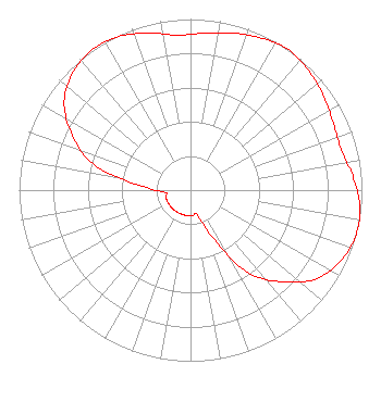 | ||||||||||||||||||
| Azimuth | Ratio | Azimuth | Ratio | Azimuth | Ratio | Azimuth | Ratio | ||||||||||||
| 5 | 0.920 | 15 | 0.950 | 25 | 0.980 | 35 | 1.000 | ||||||||||||
| 45 | 0.980 | 55 | 0.950 | 65 | 0.920 | 75 | 0.910 | ||||||||||||
| 85 | 0.950 | 95 | 0.990 | 105 | 1.000 | 115 | 0.970 | ||||||||||||
| 125 | 0.900 | 135 | 0.760 | 145 | 0.590 | 155 | 0.300 | ||||||||||||
| 165 | 0.150 | 175 | 0.150 | 185 | 0.150 | 195 | 0.150 | ||||||||||||
| 205 | 0.150 | 215 | 0.150 | 225 | 0.150 | 235 | 0.150 | ||||||||||||
| 245 | 0.150 | 255 | 0.150 | 265 | 0.150 | 275 | 0.300 | ||||||||||||
| 285 | 0.590 | 295 | 0.760 | 305 | 0.900 | 315 | 0.970 | ||||||||||||
| 325 | 1.000 | 335 | 0.990 | 345 | 0.950 | 355 | 0.910 | ||||||||||||
Structure Registration Number 1018923 Structure Type: GTOWER Registered To: American Towers LLC Structure Address: 4262 Friendship Rd (026002 / Buford) Buford, GA County Name: Hall County ASR Issued: 08/23/2019 Date Built: 11/17/2008 Site Elevation: 370.6 m (1216 ft.) Structure Height: 256 m (840 ft.) Height Overall: 257.8 m (846 ft.) Overall Height AMSL: 628.4 m (2062 ft.) FAA Determination: 03/26/2019 FAA Study #: 2019-ASO-10136-OE FAA Circular #: 70/7460-1L Paint & Light FAA Chapters: 4, 9, 12 34-07-47.9 N 83-55-55.7 W (NAD 83) 34-07-47.5 N 83-55-56.0 W (Converted to NAD 27) |
3901 Highway 121 South Bedford, TX 76021 Phone: 817-571-1229 Not-for-Profit | Date: 12/13/2012 Application Certifier WORD OF GOD FELLOWSHIP, INC. 3901 Highway 121 South Bedford, TX 76021 Applicant RICHARD C GOETZ 135 N Country Club Dr Hendersonville, TN 37075 BROADCAST CONSULTANT HENRY TURNER Word Of God Fellowship, Inc. | |||||||||||||||||