
FCCInfo.com
A Service of Cavell, Mertz & Associates, Inc.
(855) FCC-INFO
|
|
|
|
|
|||||||||||||||||||||||||||||||
|
|
Status: License Application Accepted: 06/26/2012 License Expires: 02/01/2023 File Number: BLDTV-20120626ACM Prefix Type: This is BLDTV FCC Website Links: LMS Facility Details This Application Other K04JH-D Applications Including Superseded Applications Mailing Address Correspondence for K04JH-D Correspondence related to application BLDTV-20120626ACM Service Contour - Open Street Map or USGS Map (43 dBu) Service Contour - KML / Google Earth (43 dBu) Rabbit Ears Info Search for K04JH-D Site Location: 59-27-15.0 N 151-40-26.0 W (NAD 83) Site Location: 59-27-17.2 N 151-40-18.4 W (Converted to NAD 27) ERP: 0.303 kW R/C AGL: 37 m (121 ft.) R/C AMSL: 372.3 m (1221 ft.) Emission Mask: Simple Site Elevation: 335.3 m. (1100 ft.) Height Overall*: 54.9 m (180 ft.) (* As Filed In This Application, may differ from ASR Data, Below.) Directional Antenna - Antenna Make/Model: Scala CL-26 Antenna ID: 20783
| |||||||||||||||||||||||||||||||||
| Antenna Data for Antenna Id: 20783 K04JH-D LD File: BLDTV-20120626ACM Scala - CL-26 Service: LD Standard Pattern: Y Pattern and Field Values Include a 20° Clockwise Rotation | 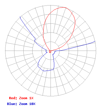 | |||||||||||||||||||||||||||||||||
| Azimuth | Ratio | Azimuth | Ratio | Azimuth | Ratio | Azimuth | Ratio | |||||||||||||||||||||||||||
| 0 | 0.830 | 10 | 0.940 | 15 | 0.980 | 20 | 1.000 | |||||||||||||||||||||||||||
| 25 | 0.980 | 30 | 0.940 | 40 | 0.840 | 50 | 0.650 | |||||||||||||||||||||||||||
| 60 | 0.460 | 70 | 0.290 | 80 | 0.080 | 90 | 0.020 | |||||||||||||||||||||||||||
| 100 | 0.010 | 110 | 0.010 | 120 | 0.010 | 130 | 0.010 | |||||||||||||||||||||||||||
| 140 | 0.010 | 150 | 0.010 | 160 | 0.020 | 170 | 0.040 | |||||||||||||||||||||||||||
| 180 | 0.043 | 190 | 0.045 | 200 | 0.047 | 210 | 0.045 | |||||||||||||||||||||||||||
| 220 | 0.043 | 230 | 0.030 | 240 | 0.010 | 250 | 0.010 | |||||||||||||||||||||||||||
| 260 | 0.010 | 270 | 0.010 | 280 | 0.010 | 290 | 0.020 | |||||||||||||||||||||||||||
| 300 | 0.040 | 310 | 0.050 | 320 | 0.130 | 330 | 0.300 | |||||||||||||||||||||||||||
| 340 | 0.460 | 350 | 0.660 | |||||||||||||||||||||||||||||||
Structure Registration Number 1003109 Structure Type: TOWER Registered To: State of Alaska Structure Address: Rural Location On Ridge 1.5 Mi Ne Seldovia, AK County Name: Kenai Peninsula Borough ASR Issued: 09/10/2015 Date Built: 11/01/1988 Site Elevation: 335.3 m (1100 ft.) Structure Height: 54.9 m (180 ft.) Height Overall: 54.9 m (180 ft.) Overall Height AMSL: 390.1 m (1280 ft.) FAA Determination: 10/26/1988 FAA Study #: 88-AAL-70-OE FAA Circular #: 70/7460-1G Paint & Light FAA Chapters: 3, 4, 5, 9 59-27-15.0 N 151-40-26.0 W (NAD 83) 59-27-17.2 N 151-40-18.4 W (Converted to NAD 27) |
2750 Luberon Lane Cumming, GA 30041 Phone: 678-777-8659 Applicant | Date: 06/26/2012 Application Certifier COASTAL TELEVISION BROADCASTING COMPANY LLC 2665 Strathmore Drive Cumming, GA 30041 Applicant BYRON W. ST. CLAIR 2355 Ranch Dr. Westminster, CO 80234 ENGINEERING CONSULTANT FRANK R. JAZZO, ESQ. Fletcher, Heald & Hildreth, P.l.c. | ||||||||||||||||||||||||||||||||
| ||||||||||||||||||||||||||||||||||