
FCCInfo.com
A Service of Cavell, Mertz & Associates, Inc.
(855) FCC-INFO
|
|
WPXC-TV from 05/08/1996 WPXC-TV from 05/06/1996 WPXC-TV from 05/02/1988 |
Virtual Channel 21 |  |
|
|||||||||||||||
|
|
Repacking Information: No changes Status: License Application Accepted: 04/26/2011 License Expires: 04/01/2021 File Number: BLCDT-20110426AAQ Prefix Type: This is a License for a commercial digital TV station FCC Website Links: LMS Facility Details This Application Other WPXC-TV Applications Including Superseded Applications Mailing Address Correspondence for WPXC-TV Correspondence related to application BLCDT-20110426AAQ Service Contour - Open Street Map or USGS Map (41 dBu) Service Contour - KML / Google Earth (41 dBu) Public Inspection Files Rabbit Ears Info Search for WPXC-TV Site Location: 30-49-39.8 N 81-44-26.4 W (NAD 83) Site Location: 30-49-39.0 N 81-44-27.0 W (Converted to NAD 27) ERP: 790 kW Polarization: Horizontally polarized HAAT: 417 m (1368 ft.) Electrical Beam Tilt: 0.9 degrees R/C AGL: 414.5 m (1360 ft.) R/C AMSL: 421.2 m (1382 ft.) Site Elevation: 6.7 m. (22 ft.) Height Overall*: 426.7 m (1400 ft.) (* As Filed In This Application, may differ from ASR Data, Below.) Directional Antenna - Antenna Make/Model: DIELECTRIC TFU-26DSC-R C170 Antenna ID: 87448 Polarization: Horizontally polarized | ||||||||||||||||||
| Antenna Data for Antenna Id: 87448 WPXC-TV DT File: BLCDT-20110426AAQ DIELECTRIC - TFU-26DSC-R C170 Service: DT Standard Pattern: Y | 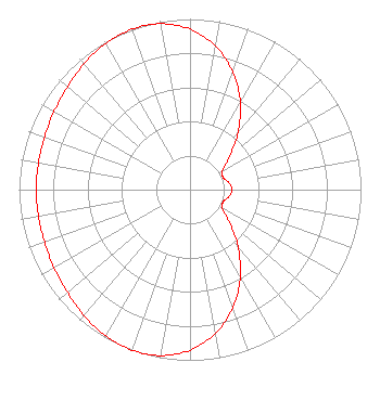 | ||||||||||||||||||
| Azimuth | Ratio | Azimuth | Ratio | Azimuth | Ratio | Azimuth | Ratio | ||||||||||||
| 0 | 0.940 | 10 | 0.854 | 20 | 0.733 | 30 | 0.588 | ||||||||||||
| 40 | 0.437 | 50 | 0.302 | 60 | 0.218 | 70 | 0.207 | ||||||||||||
| 80 | 0.232 | 90 | 0.245 | 100 | 0.232 | 110 | 0.207 | ||||||||||||
| 120 | 0.218 | 130 | 0.302 | 140 | 0.437 | 150 | 0.588 | ||||||||||||
| 160 | 0.733 | 170 | 0.854 | 180 | 0.940 | 190 | 0.987 | ||||||||||||
| 200 | 1.000 | 210 | 0.988 | 220 | 0.963 | 230 | 0.936 | ||||||||||||
| 240 | 0.917 | 250 | 0.905 | 260 | 0.900 | 270 | 0.899 | ||||||||||||
| 280 | 0.900 | 290 | 0.905 | 300 | 0.917 | 310 | 0.936 | ||||||||||||
| 320 | 0.963 | 330 | 0.988 | 340 | 1.000 | 350 | 0.987 | ||||||||||||
Structure Registration Number 1247774 Structure Type: GTOWER Registered To: ION Station Properties, LLC Structure Address: Approximately 2.2 Km Ne Of The Intersection Of State Route 40 And Colerian Road Camden County, GA County Name: Camden County ASR Issued: 05/31/2022 Date Built: 05/17/2006 Site Elevation: 6.7 m (22 ft.) Structure Height: 402.3 m (1320 ft.) Height Overall: 426.7 m (1400 ft.) Overall Height AMSL: 433.4 m (1422 ft.) FAA Determination: 06/01/2021 FAA Study #: 2021-ASO-15668-OE FAA Circular #: 70/7460-1M Paint & Light FAA Chapters: 4, 9, 15 PRIOR STUDY 2004-ASO-6763-OE 30-49-39.8 N 81-44-26.4 W (NAD 83) 30-49-39.0 N 81-44-27.0 W (Converted to NAD 27) |
312 Walnut Street 28th Floor Cincinnati, OH 45202 Phone: 513-977-3000 Limited Liability Company | Date: 04/26/2011 Application Certifier ION MEDIA BRUNSWICK LICENSE, INC. 601 Clearwater Park Road West Palm Beach, FL 33401-6233 Applicant WILLIAM L. WATSON Ion Media Networks, Inc. 601 Clearwater Park Road West Palm Beach, FL 33401-6233 PAUL TITCHENAL 14444 66th Street North Clearwater, FL 33764 DIRECTOR OF BROADCAST DEVELOPMENT | |||||||||||||||||