
FCCInfo.com
A Service of Cavell, Mertz & Associates, Inc.
(855) FCC-INFO
|
|
WNGJ-LD from 02/03/2015 WNGJ-LD from 03/28/2008 |
|
|
||||||||||||||||
|
|
Status: License Application Accepted: 03/18/2011 License Expires: 06/01/2023 File Number: BLTTL-20110318AEZ Prefix Type: This is a license for a UHF LPTV station FCC Website Links: LMS Facility Details This Application Other WNGJ-LD Applications Including Superseded Applications Mailing Address Correspondence for WNGJ-LD Correspondence related to application BLTTL-20110318AEZ Service Contour - Open Street Map or USGS Map (74 dBu) Service Contour - KML / Google Earth (74 dBu) Rabbit Ears Info Search for WNGJ-LD Site Location: 44-39-00.0 N 75-27-21.0 W (NAD 83) Site Location: 44-38-59.8 N 75-27-22.2 W (Converted to NAD 27) ERP: 2 kW R/C AGL: 40 m (131 ft.) R/C AMSL: 140 m (459 ft.) Site Elevation: 100 m. (328 ft.) Height Overall*: 59 m (194 ft.) (* As Filed In This Application, may differ from ASR Data, Below.) Directional Antenna - Antenna Make/Model: Scala SL-8 Antenna ID: 23503 | ||||||||||||||||||
| Antenna Data for Antenna Id: 23503 WNGJ-LD TX File: BLTTL-20110318AEZ Scala - SL-8 Service: TX Standard Pattern: Y Pattern and Field Values Include a 330° Clockwise Rotation | 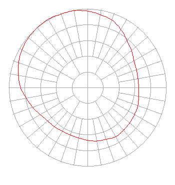 | ||||||||||||||||||
| Azimuth | Ratio | Azimuth | Ratio | Azimuth | Ratio | Azimuth | Ratio | ||||||||||||
| 0 | 0.970 | 10 | 0.940 | 20 | 0.910 | 30 | 0.850 | ||||||||||||
| 40 | 0.780 | 50 | 0.730 | 60 | 0.680 | 70 | 0.660 | ||||||||||||
| 80 | 0.650 | 90 | 0.650 | 100 | 0.660 | 110 | 0.680 | ||||||||||||
| 120 | 0.690 | 130 | 0.700 | 140 | 0.710 | 150 | 0.720 | ||||||||||||
| 160 | 0.700 | 170 | 0.690 | 180 | 0.670 | 190 | 0.650 | ||||||||||||
| 200 | 0.640 | 210 | 0.640 | 220 | 0.650 | 230 | 0.660 | ||||||||||||
| 240 | 0.690 | 250 | 0.740 | 260 | 0.790 | 270 | 0.850 | ||||||||||||
| 280 | 0.890 | 290 | 0.930 | 300 | 0.960 | 310 | 0.980 | ||||||||||||
| 320 | 0.990 | 330 | 1.000 | 340 | 0.990 | 350 | 0.990 | ||||||||||||
Structure Registration Number 1004373 [ASR Heights Differ from WNGJ-LD Application] Structure Type: TOWER Registered To: CCATT LLC Structure Address: 1/2 Mi. North Of Inter. Of Delaney & Eelweir Rds. Oswegatchie, NY County Name: St. Lawrence County ASR Issued: 05/09/2016 Date Built: 02/10/1997 Site Elevation: 99.7 m (327 ft.) Structure Height: 55.5 m (182 ft.) Height Overall: 58.5 m (192 ft.) Overall Height AMSL: 158.2 m (519 ft.) FAA Determination: 10/09/1996 FAA Study #: 96-AEA-1581-OE Paint & Light FAA Chapters: NONE 44-39-00.0 N 75-27-21.0 W (NAD 83) 44-38-59.8 N 75-27-22.2 W (Converted to NAD 27) |
65 King Rd Buskirk, NY 12028 Phone: 518-686-0975 Applicant | Date: 03/18/2011 Application Certifier NORTHEAST GOSPEL BROADCASTING INC. 65 King Rd Buskirk, NY 12028-0036 Applicant DANNY LANGSTON Sterling Communications, Inc. 219 Dodd Rd. Ringgold, GA 30736-2958 TECHNICAL CONSULTANT JAMES E. PRICE III Sterling Communications, Inc. | |||||||||||||||||