
FCCInfo.com
A Service of Cavell, Mertz & Associates, Inc.
(855) FCC-INFO
|
|
K46KI-D from 01/28/1982 |
|
|
||||||||||||||||
|
|
Status: License Application Accepted: 03/08/2010 License Expires: 04/01/2022 File Number: BLDTT-20100308AAH Prefix Type: This is BLDTT FCC Website Links: LMS Facility Details This Application Other K46KI-D Applications Including Superseded Applications Mailing Address Correspondence for K46KI-D Correspondence related to application BLDTT-20100308AAH Service Contour - Open Street Map or USGS Map (51 dBu) Service Contour - KML / Google Earth (51 dBu) Rabbit Ears Info Search for K46KI-D Site Location: 39-18-37.3 N 106-56-55.0 W (NAD 83) Site Location: 39-18-37.4 N 106-56-52.8 W (Converted to NAD 27) ERP: 0.045 kW R/C AGL: 9 m (30 ft.) R/C AMSL: 2692 m (8832 ft.) Emission Mask: Simple Site Elevation: 2683 m. (8802 ft.) Height Overall*: 15.8 m (52 ft.) (* As Filed In This Application, may differ from ASR Data, Below.) Directional Antenna - Antenna Make/Model: Kathrein TWO K723147 @ 137, 227 DEG Antenna ID: 93084
| ||||||||||||||||||
| Antenna Data for Antenna Id: 93084 K46KI-D LD File: BLDTT-20100308AAH Kathrein - TWO K723147 @ 137, 227 DEG Service: LD Standard Pattern: Y | 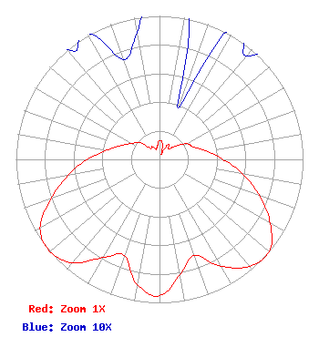 | ||||||||||||||||||
| Azimuth | Ratio | Azimuth | Ratio | Azimuth | Ratio | Azimuth | Ratio | ||||||||||||
| 0 | 0.132 | 10 | 0.114 | 20 | 0.038 | 30 | 0.118 | ||||||||||||
| 40 | 0.094 | 50 | 0.139 | 60 | 0.219 | 70 | 0.251 | ||||||||||||
| 80 | 0.333 | 90 | 0.444 | 100 | 0.591 | 110 | 0.742 | ||||||||||||
| 120 | 0.891 | 130 | 1.000 | 140 | 0.974 | 150 | 0.860 | ||||||||||||
| 160 | 0.712 | 170 | 0.815 | 180 | 0.951 | 190 | 0.888 | ||||||||||||
| 200 | 0.714 | 210 | 0.791 | 220 | 0.941 | 230 | 0.998 | ||||||||||||
| 240 | 0.961 | 250 | 0.805 | 260 | 0.651 | 270 | 0.503 | ||||||||||||
| 280 | 0.371 | 290 | 0.283 | 300 | 0.223 | 310 | 0.183 | ||||||||||||
| 320 | 0.101 | 330 | 0.103 | 340 | 0.074 | 350 | 0.090 | ||||||||||||
Structure Registration Number 1242304 Structure Type: TOWER Registered To: Pitkin County Translator Department Structure Address: Williams Hill Snowmass Village, CO County Name: Pitkin County ASR Issued: 12/30/2014 Date Built: 01/31/2008 Site Elevation: 2682.8 m (8802 ft.) Structure Height: 15.8 m (52 ft.) Height Overall: 15.8 m (52 ft.) Overall Height AMSL: 2698.6 m (8854 ft.) FAA Determination: 07/18/2008 FAA Study #: 2008-ANM-2244-OE Paint & Light FAA Chapters: NONE PRIOR STUDY 2002-ANM-403-OE 39-18-37.3 N 106-56-55.0 W (NAD 83) 39-18-37.4 N 106-56-52.8 W (Converted to NAD 27) |
351 Southside Dr. Basalt, CO 81621 Phone: 970-429-6114 Government Entity | Date: 03/08/2010 Application Certifier PITKIN COUNTY TRANSLATOR DEPARTMENT 76 Service Center Road Aspen, CO 81611 Applicant JON V BANKS 1015 Park West Drive Glenwood Springs, CO 81601 TECHNICAL CONSULTANT HENRY A. SOLOMON, ESQ. Garvey Schubert Barer | |||||||||||||||||