
FCCInfo.com
A Service of Cavell, Mertz & Associates, Inc.
(855) FCC-INFO
|
|
KLVD-LD from 06/29/2004 KLVD-LD from 02/05/1993 |
|
|
||||||||||||||||
|
|
Status: License Application Accepted: 07/28/2011 License Expires: 10/01/2022 File Number: BLDTL-20110728ADN Prefix Type: This is BLDTL FCC Website Links: LMS Facility Details This Application Other KLVD-LD Applications Including Superseded Applications Mailing Address Correspondence for KLVD-LD Correspondence related to application BLDTL-20110728ADN Service Contour - Open Street Map or USGS Map (51 dBu) Service Contour - KML / Google Earth (51 dBu) Rabbit Ears Info Search for KLVD-LD Site Location: 36-00-36.4 N 115-00-22.7 W (NAD 83) Site Location: 36-00-36.5 N 115-00-19.7 W (Converted to NAD 27) ERP: 15 kW Electrical Beam Tilt: 0.5 degrees R/C AGL: 67 m (220 ft.) R/C AMSL: 1051 m (3448 ft.) Emission Mask: Stringent Site Elevation: 984 m. (3228 ft.) Height Overall*: 72.2 m (237 ft.) (* As Filed In This Application, may differ from ASR Data, Below.) Directional Antenna - Antenna Make/Model: Propagation System Inc PSILP24BB Antenna ID: 20421 | ||||||||||||||||||
| Antenna Data for Antenna Id: 20421 KLVD-LD LD File: BLDTL-20110728ADN Propagation System Inc - PSILP24BB Service: LD Standard Pattern: Y Pattern and Field Values Include a 320° Clockwise Rotation | 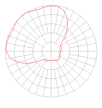 | ||||||||||||||||||
| Azimuth | Ratio | Azimuth | Ratio | Azimuth | Ratio | Azimuth | Ratio | ||||||||||||
| 0 | 0.980 | 10 | 0.970 | 20 | 0.890 | 30 | 0.720 | ||||||||||||
| 40 | 0.520 | 50 | 0.330 | 60 | 0.240 | 70 | 0.240 | ||||||||||||
| 80 | 0.230 | 90 | 0.210 | 100 | 0.200 | 110 | 0.210 | ||||||||||||
| 120 | 0.220 | 130 | 0.240 | 140 | 0.250 | 150 | 0.240 | ||||||||||||
| 160 | 0.220 | 170 | 0.210 | 180 | 0.200 | 190 | 0.210 | ||||||||||||
| 200 | 0.230 | 210 | 0.240 | 220 | 0.240 | 230 | 0.330 | ||||||||||||
| 240 | 0.520 | 250 | 0.720 | 260 | 0.890 | 270 | 0.970 | ||||||||||||
| 280 | 0.980 | 290 | 0.960 | 300 | 0.950 | 310 | 0.980 | ||||||||||||
| 320 | 1.000 | 330 | 0.980 | 340 | 0.950 | 350 | 0.960 | ||||||||||||
Structure Registration Number 1009985 [ASR Heights Differ from KLVD-LD Application] Structure Type: LTOWER Registered To: American Towers LLC Structure Address: Black Mountain Road .7 Miles West Of I-515 ( Black Mountain Twr 4, 90348) Henderson, NV County Name: Clark County ASR Issued: 06/15/2017 Date Built: 08/24/2001 Site Elevation: 983.9 m (3228 ft.) Structure Height: 75.3 m (247 ft.) Height Overall: 76.8 m (252 ft.) Overall Height AMSL: 1060.7 m (3480 ft.) FAA Determination: 06/14/2017 FAA Study #: 2017-AWP-6247-OE FAA Circular #: 70/7460-1L Paint & Light FAA Chapters: 4, 6, 12 PRIOR STUDY 2016-AWP-4219-OE 36-00-36.4 N 115-00-22.7 W (NAD 83) 36-00-36.5 N 115-00-19.7 W (Converted to NAD 27) |
3901 Highway 121 South Bedford, TX 76021 Phone: 817-571-1229 Corporation | Date: 07/28/2011 Application Certifier WORD OF GOD FELLOWSHIP, INC. 3901 Highway 121 South Bedford, TX 76021 Applicant RICHARD C GOETZ 135 N Country Club Dr Hendersonville, TN 37075 BROADCAST CONSULTANT ARNOLD TORRES Word Of God Fellowship, Inc. | |||||||||||||||||