
FCCInfo.com
A Service of Cavell, Mertz & Associates, Inc.
(855) FCC-INFO
|
|
WZPJ-LD from 12/07/2006 |
Virtual Channel 4 |
|
||||||||||||||||
|
|
Status: License Application Accepted: 12/01/2006 License Expires: 04/01/2023 File Number: BLTTL-20061201AAG Prefix Type: This is a license for a UHF LPTV station FCC Website Links: LMS Facility Details This Application Other WZPJ-LD Applications Including Superseded Applications Mailing Address Correspondence for WZPJ-LD Correspondence related to application BLTTL-20061201AAG Service Contour - Open Street Map or USGS Map (74 dBu) Service Contour - KML / Google Earth (74 dBu) Rabbit Ears Info Search for WZPJ-LD Site Location: 43-01-13.0 N 73-31-27.0 W (NAD 83) Site Location: 43-01-12.7 N 73-31-28.6 W (Converted to NAD 27) ERP: 50 kW R/C AGL: 40 m (131 ft.) R/C AMSL: 471.3 m (1546 ft.) Site Elevation: 431.3 m. (1415 ft.) Height Overall*: 45.7 m (150 ft.) (* As Filed In This Application, may differ from ASR Data, Below.) Directional Antenna - Antenna Make/Model: Scala PRTV ARRAY Antenna ID: 71934 | ||||||||||||||||||
| Antenna Data for Antenna Id: 71934 WZPJ-LD TX File: BLTTL-20061201AAG Scala - PRTV ARRAY Service: TX Standard Pattern: Y Pattern and Field Values Include a 215° Clockwise Rotation | 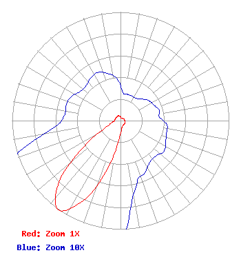 | ||||||||||||||||||
| Azimuth | Ratio | Azimuth | Ratio | Azimuth | Ratio | Azimuth | Ratio | ||||||||||||
| 5 | 0.026 | 15 | 0.025 | 25 | 0.025 | 35 | 0.025 | ||||||||||||
| 45 | 0.028 | 55 | 0.032 | 65 | 0.034 | 75 | 0.037 | ||||||||||||
| 85 | 0.036 | 95 | 0.043 | 105 | 0.044 | 115 | 0.046 | ||||||||||||
| 125 | 0.049 | 135 | 0.046 | 145 | 0.047 | 155 | 0.053 | ||||||||||||
| 165 | 0.059 | 175 | 0.090 | 185 | 0.180 | 195 | 0.460 | ||||||||||||
| 205 | 0.815 | 215 | 1.000 | 225 | 0.800 | 235 | 0.400 | ||||||||||||
| 245 | 0.150 | 255 | 0.090 | 265 | 0.060 | 275 | 0.052 | ||||||||||||
| 285 | 0.052 | 295 | 0.051 | 305 | 0.046 | 315 | 0.045 | ||||||||||||
| 325 | 0.048 | 335 | 0.049 | 345 | 0.045 | 355 | 0.039 | ||||||||||||
Structure Registration Number 1213944 Structure Type: TOWER Registered To: American Towers LLC Structure Address: Sumit Of Willard Mtn Easton, NY County Name: Washington County ASR Issued: 01/05/2021 Site Elevation: 431.3 m (1415 ft.) Structure Height: 45.7 m (150 ft.) Height Overall: 45.7 m (150 ft.) Overall Height AMSL: 477 m (1565 ft.) FAA Determination: 04/10/2000 FAA Study #: 00-AEA-0956-OE FAA Circular #: Paint & Light FAA Chapters: NONE 43-01-13.0 N 73-31-27.0 W (NAD 83) 43-01-12.7 N 73-31-28.6 W (Converted to NAD 27) |
500 Summer Street #502 Stamford, CT 06901 Phone: 203-349-9000 Limited Liability Company | Date: 12/01/2006 Application Certifier COMMERCIAL BROADCASTING CORP. 1903 S. Greeley Hwy. # 127 Cheyenne, WY 82007 Applicant RANDOLPH WEIGNER Po Box 1001 Meredith, NH 03253 PRESIDENT COMMERCIAL BROADCASTING CORP. | |||||||||||||||||