
FCCInfo.com
A Service of Cavell, Mertz & Associates, Inc.
(855) FCC-INFO
|
|
KLKW-LD from 11/07/2012 |
|
|
||||||||||||||||
|
|
Status: License Application Accepted: 04/14/2014 License Expires: 08/01/2022 File Number: BLDTL-20140414ADY Prefix Type: This is BLDTL FCC Website Links: LMS Facility Details This Application Other KLKW-LD Applications Including Superseded Applications Mailing Address Correspondence for KLKW-LD Correspondence related to application BLDTL-20140414ADY Service Contour - Open Street Map or USGS Map (51 dBu) Service Contour - KML / Google Earth (51 dBu) Rabbit Ears Info Search for KLKW-LD Site Location: 35-10-21.0 N 101-57-15.0 W (NAD 83) Site Location: 35-10-20.8 N 101-57-13.3 W (Converted to NAD 27) ERP: 1 kW R/C AGL: 103.6 m (340 ft.) R/C AMSL: 1242.6 m (4077 ft.) Emission Mask: Stringent Site Elevation: 1139 m. (3737 ft.) Height Overall*: 128 m (420 ft.) (* As Filed In This Application, may differ from ASR Data, Below.) Directional Antenna - Antenna Make/Model: DIELECTRIC TUA-C2-1/2M-1-K Antenna ID: 117899 | ||||||||||||||||||
| Antenna Data for Antenna Id: 117899 KLKW-LD LD File: BLDTL-20140414ADY DIELECTRIC - TUA-C2-1/2M-1-K Service: LD Standard Pattern: Y Pattern and Field Values Include a 45° Clockwise Rotation | 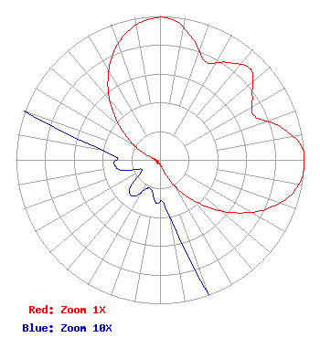 | ||||||||||||||||||
| Azimuth | Ratio | Azimuth | Ratio | Azimuth | Ratio | Azimuth | Ratio | ||||||||||||
| 5 | 0.981 | 15 | 0.874 | 25 | 0.753 | 35 | 0.826 | ||||||||||||
| 45 | 0.889 | 55 | 0.782 | 65 | 0.722 | 75 | 0.873 | ||||||||||||
| 85 | 0.989 | 95 | 1.000 | 105 | 0.941 | 115 | 0.812 | ||||||||||||
| 125 | 0.642 | 135 | 0.461 | 145 | 0.292 | 155 | 0.156 | ||||||||||||
| 165 | 0.063 | 175 | 0.031 | 185 | 0.030 | 195 | 0.022 | ||||||||||||
| 205 | 0.022 | 215 | 0.031 | 225 | 0.030 | 235 | 0.017 | ||||||||||||
| 245 | 0.015 | 255 | 0.028 | 265 | 0.032 | 275 | 0.032 | ||||||||||||
| 285 | 0.063 | 295 | 0.155 | 305 | 0.290 | 315 | 0.456 | ||||||||||||
| 325 | 0.631 | 335 | 0.791 | 345 | 0.911 | 355 | 0.979 | ||||||||||||
Structure Registration Number 1054173 [ASR Heights Differ from KLKW-LD Application] Structure Type: GTOWER Registered To: Omega 2 Way Radio, LC Structure Address: 1/4 Mi Se Of Int Of 34th & Helium Amarillo, TX County Name: Randall County ASR Issued: 05/02/2016 Date Built: 05/01/1989 Site Elevation: 1150.9 m (3776 ft.) Structure Height: 122 m (400 ft.) Height Overall: 128 m (420 ft.) Overall Height AMSL: 1278.9 m (4196 ft.) FAA Determination: 04/20/2016 FAA Study #: 2016-ASW-3534-OE Paint & Light FAA Chapters: A2, H PRIOR STUDY 1989-ASW-750-OE 35-10-25.9 N 101-57-14.5 W (NAD 83) 35-10-25.7 N 101-57-12.8 W (Converted to NAD 27) |
295 Madison Avenue, 12th Floor New York, NY 10017 Phone: 954-606-5486 Corporation | Date: 04/14/2014 Application Certifier DTV AMERICA CORPORATION 1671 Nw 144th Terrace Suite 106 Sunrise, FL 33323 Applicant JAMES GALLAGHER 2398 Commercial Way Suite 226 Spring Hill, FL 34667 CONSULTANT DTV AMERICA CORPORATION | |||||||||||||||||