
FCCInfo.com
A Service of Cavell, Mertz & Associates, Inc.
(855) FCC-INFO
|
|
K26PQ-D from 05/09/2002 |
|
|
||||||||||||||||
|
|
Status: License Application Accepted: 06/18/2002 License Expires: 12/01/2022 File Number: BLTVL-20020618AAT Prefix Type: This is a license for a VHF LPTV station FCC Website Links: LMS Facility Details This Application Other K26PQ-D Applications Including Superseded Applications Mailing Address Correspondence for K26PQ-D Correspondence related to application BLTVL-20020618AAT Service Contour - Open Street Map or USGS Map (68 dBu) Service Contour - KML / Google Earth (68 dBu) Rabbit Ears Info Search for K26PQ-D Site Location: 39-27-46.0 N 121-34-53.0 W (NAD 83) Site Location: 39-27-46.4 N 121-34-49.1 W (Converted to NAD 27) ERP: 3 kW R/C AGL: 29 m (95 ft.) R/C AMSL: 101.5 m (333 ft.) Site Elevation: 72.5 m. (238 ft.) Height Overall*: 30.5 m (100 ft.) (* As Filed In This Application, may differ from ASR Data, Below.) Directional Antenna - Antenna Make/Model: Jampro JAHD-2/1 (2) Antenna ID: 39174 | ||||||||||||||||||
| Antenna Data for Antenna Id: 39174 K26PQ-D TX File: BLTVL-20020618AAT Jampro - JAHD-2/1 (2) Service: TX Standard Pattern: Y | 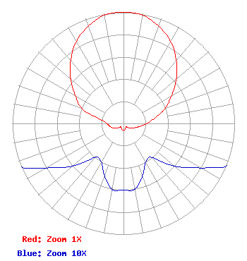 | ||||||||||||||||||
| Azimuth | Ratio | Azimuth | Ratio | Azimuth | Ratio | Azimuth | Ratio | ||||||||||||
| 0 | 1.000 | 10 | 0.990 | 20 | 0.930 | 30 | 0.850 | ||||||||||||
| 40 | 0.740 | 50 | 0.620 | 60 | 0.500 | 70 | 0.400 | ||||||||||||
| 80 | 0.290 | 90 | 0.210 | 100 | 0.150 | 110 | 0.110 | ||||||||||||
| 120 | 0.080 | 130 | 0.060 | 140 | 0.040 | 150 | 0.040 | ||||||||||||
| 160 | 0.050 | 170 | 0.060 | 180 | 0.060 | 190 | 0.060 | ||||||||||||
| 200 | 0.050 | 210 | 0.040 | 220 | 0.040 | 230 | 0.060 | ||||||||||||
| 240 | 0.080 | 250 | 0.110 | 260 | 0.130 | 270 | 0.150 | ||||||||||||
| 280 | 0.210 | 290 | 0.400 | 300 | 0.500 | 310 | 0.620 | ||||||||||||
| 320 | 0.740 | 330 | 0.850 | 340 | 0.930 | 350 | 0.990 | ||||||||||||
Structure Registration Number 1063515 Structure Type: TOWER Registered To: Sinclair Television of California, LLC Structure Address: Hwy 70 Approx 5 Km Sw Oroville, CA County Name: Butte County ASR Issued: 03/05/2024 Date Built: 08/01/1999 Site Elevation: 72.5 m (238 ft.) Structure Height: 30.5 m (100 ft.) Height Overall: 30.5 m (100 ft.) Overall Height AMSL: 103 m (338 ft.) FAA Determination: 04/02/1999 FAA Study #: 99-AWP-0302-OE Paint & Light FAA Chapters: NONE 39-27-46.0 N 121-34-53.0 W (NAD 83) 39-27-46.4 N 121-34-49.1 W (Converted to NAD 27) |
10706 Beaver Dam Road Cockeysville, MD 21030 Phone: 410-568-1500 Limited Liability Company | Date: 06/18/2002 Application Certifier SAINTE PARTNERS II, L.P. P. O. Box 4159 Modesto, CA 95352-4159 Applicant MEL FREEDMAN 2612 Portsmouth La Modesto, CA 95355 KATHLEEN VICTORY, ESQ. Fletcher Heald & Hildreth, Plc | |||||||||||||||||