
FCCInfo.com
A Service of Cavell, Mertz & Associates, Inc.
(855) FCC-INFO
|
|
KLWY from 03/28/1985 KLWY from 12/22/1981 |
Virtual Channel 27 |
|
|||||||||||||||||||||||||||||||
|
|
Repacking Information: No changes Status: License Application Accepted: 02/27/2009 License Expires: 10/01/2022 File Number: BLCDT-20090227AAD Prefix Type: This is a License for a commercial digital TV station FCC Website Links: LMS Facility Details This Application Other KLWY Applications Including Superseded Applications Mailing Address Correspondence for KLWY Correspondence related to application BLCDT-20090227AAD Service Contour - Open Street Map or USGS Map (41 dBu) Service Contour - KML / Google Earth (41 dBu) Public Inspection Files History Cards for KLWY Rabbit Ears Info Search for KLWY Site Location: 41-03-00.5 N 104-53-33.5 W (NAD 83) Site Location: 41-03-00.6 N 104-53-31.6 W (Converted to NAD 27) ERP: 169 kW Polarization: Horizontally polarized HAAT: 232 m (761 ft.) Electrical Beam Tilt: 0.5 degrees R/C AGL: 184.4 m (605 ft.) R/C AMSL: 2135.4 m (7006 ft.) Site Elevation: 1951 m. (6401 ft.) Height Overall*: 193.5 m (635 ft.) (* As Filed In This Application, may differ from ASR Data, Below.) Directional Antenna - Antenna Make/Model: Bogner BUI28G Antenna ID: 87213 Polarization: Horizontally polarized | |||||||||||||||||||||||||||||||||
| Antenna Data for Antenna Id: 87213 KLWY DT File: BLCDT-20090227AAD Bogner - BUI28G Service: DT Standard Pattern: Y | 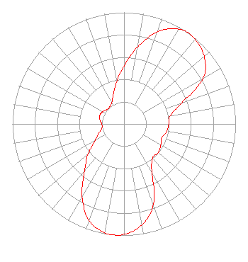 | |||||||||||||||||||||||||||||||||
| Azimuth | Ratio | Azimuth | Ratio | Azimuth | Ratio | Azimuth | Ratio | |||||||||||||||||||||||||||
| 0 | 0.520 | 10 | 0.700 | 20 | 0.880 | 30 | 0.980 | |||||||||||||||||||||||||||
| 35 | 1.000 | 40 | 0.990 | 50 | 0.940 | 60 | 0.820 | |||||||||||||||||||||||||||
| 70 | 0.550 | 80 | 0.420 | 90 | 0.400 | 100 | 0.390 | |||||||||||||||||||||||||||
| 110 | 0.360 | 120 | 0.380 | 130 | 0.400 | 140 | 0.400 | |||||||||||||||||||||||||||
| 150 | 0.500 | 160 | 0.770 | 170 | 0.920 | 180 | 0.990 | |||||||||||||||||||||||||||
| 185 | 1.000 | 190 | 0.990 | 200 | 0.920 | 210 | 0.750 | |||||||||||||||||||||||||||
| 220 | 0.550 | 230 | 0.420 | 240 | 0.300 | 250 | 0.240 | |||||||||||||||||||||||||||
| 260 | 0.200 | 270 | 0.200 | 280 | 0.220 | 290 | 0.230 | |||||||||||||||||||||||||||
| 300 | 0.220 | 310 | 0.200 | 320 | 0.200 | 330 | 0.220 | |||||||||||||||||||||||||||
| 340 | 0.280 | 350 | 0.380 | |||||||||||||||||||||||||||||||
Structure Registration Number 1001101 [ASR Heights Differ from KLWY Application] Structure Type: TOWER Registered To: Wyomedia Corp. Structure Address: Off Us Rt 87 .6 Mi Se Of Speer Rd Cheyenne, WY County Name: Laramie County ASR Issued: 10/20/2009 Date Built: 12/04/2009 Site Elevation: 1940.7 m (6367 ft.) Structure Height: 177 m (581 ft.) Height Overall: 193.5 m (635 ft.) Overall Height AMSL: 2134.2 m (7002 ft.) FAA Determination: 09/01/2009 FAA Study #: 2009-ANM-1391-OE Paint & Light FAA Chapters: A1, B, C, H Continue As Is OM&L = 24-HR HI-STROBES 41-03-00.5 N 104-53-33.5 W (NAD 83) 41-03-00.6 N 104-53-31.6 W (Converted to NAD 27) |
2750 Luberon Lane Cumming, GA 30041 Phone: 678-777-8659 Limited Liability Company | Date: 02/27/2009 Application Certifier WYOMEDIA CORP. 1856 Skyview Drive Casper, WY 82601 Applicant B.W. ST CLAIR 2355 Ranch Drive Westminister, CO 80234 ENGINEERING CONSULTANT HOWARD M. LIBERMAN Drinker Biddle & Reath Llp 1500 K Street, Nw Suite 1100 Washington, DC 20005 | ||||||||||||||||||||||||||||||||
| ||||||||||||||||||||||||||||||||||