
FCCInfo.com
A Service of Cavell, Mertz & Associates, Inc.
(855) FCC-INFO
|
|
WVVC-LD from 02/19/2004 WVVC-LD from 09/23/1992 |
Virtual Channel 40 |
|
||||||||||||||||
|
|
Status: License Application Accepted: 08/29/2011 License Expires: 06/01/2023 File Number: BLDTL-20110829AAZ Prefix Type: This is BLDTL FCC Website Links: LMS Facility Details This Application Other WVVC-LD Applications Including Superseded Applications Mailing Address Correspondence for WVVC-LD Correspondence related to application BLDTL-20110829AAZ Service Contour - Open Street Map or USGS Map (51 dBu) Service Contour - KML / Google Earth (51 dBu) Rabbit Ears Info Search for WVVC-LD Site Location: 43-02-14.9 N 75-11-43.5 W (NAD 83) Site Location: 43-02-14.6 N 75-11-44.9 W (Converted to NAD 27) ERP: 15 kW R/C AGL: 50 m (164 ft.) R/C AMSL: 483 m (1585 ft.) Emission Mask: Stringent Site Elevation: 433 m. (1421 ft.) Height Overall*: 56 m (184 ft.) (* As Filed In This Application, may differ from ASR Data, Below.) Directional Antenna - Antenna Make/Model: Systems With Reliability Inc. SWLP8OI Antenna ID: 24202 | ||||||||||||||||||
| Antenna Data for Antenna Id: 24202 WVVC-LD LD File: BLDTL-20110829AAZ Systems With Reliability Inc. - SWLP8OI Service: LD Standard Pattern: Y Pattern and Field Values Include a 90° Clockwise Rotation | 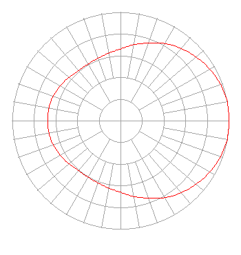 | ||||||||||||||||||
| Azimuth | Ratio | Azimuth | Ratio | Azimuth | Ratio | Azimuth | Ratio | ||||||||||||
| 0 | 0.660 | 10 | 0.710 | 20 | 0.760 | 30 | 0.820 | ||||||||||||
| 40 | 0.870 | 50 | 0.910 | 60 | 0.950 | 70 | 0.980 | ||||||||||||
| 80 | 1.000 | 90 | 1.000 | 100 | 1.000 | 110 | 0.980 | ||||||||||||
| 120 | 0.950 | 130 | 0.910 | 140 | 0.870 | 150 | 0.820 | ||||||||||||
| 160 | 0.760 | 170 | 0.710 | 180 | 0.660 | 190 | 0.630 | ||||||||||||
| 200 | 0.610 | 210 | 0.600 | 220 | 0.600 | 230 | 0.620 | ||||||||||||
| 240 | 0.640 | 250 | 0.660 | 260 | 0.670 | 270 | 0.670 | ||||||||||||
| 280 | 0.670 | 290 | 0.660 | 300 | 0.640 | 310 | 0.620 | ||||||||||||
| 320 | 0.600 | 330 | 0.600 | 340 | 0.610 | 350 | 0.630 | ||||||||||||
Structure Registration Number 1253558 Structure Type: TOWER Structure Address: Nad27 Coord. 43-02-15 N X 75-11-45 W Utica, NY County Name: Herkimer County ASR Issued: 05/23/2006 Date Built: 05/23/2006 Site Elevation: 433 m (1421 ft.) Structure Height: 56 m (184 ft.) Height Overall: 56 m (184 ft.) Overall Height AMSL: 489 m (1604 ft.) FAA Determination: 05/22/2006 FAA Study #: 2006-AEA-1908-OE FAA Circular #: 70/7460-1K Paint & Light FAA Chapters: 3, 4, 5, 12 PRIOR STUDY 1992-AEA-694-OE 43-02-14.9 N 75-11-43.5 W (NAD 83) 43-02-14.6 N 75-11-44.9 W (Converted to NAD 27) |
65 Kings Rd Buskirk, NY 12028 Phone: 518-686-0975 Applicant | Date: 08/29/2011 Application Certifier NORTHEAST GOSPEL BROADCASTING INC. 65 King Rd Buskirk, NY 12028-0036 Applicant DANNY LANGSTON Sterling Communications, Inc. 219 Dodd Rd. Ringgold, GA 30736-2958 TECHNICAL CONSULTANT JAMES E. PRICE III Sterling Communications, Inc. | |||||||||||||||||