
FCCInfo.com
A Service of Cavell, Mertz & Associates, Inc.
(855) FCC-INFO
|
|
|
|
|
||||||||||||||||
|
|
Status: License Application Accepted: 05/30/2014 License Expires: 02/01/2021 File Number: BLDTL-20140530ANG Prefix Type: This is BLDTL FCC Website Links: LMS Facility Details This Application Other W29EE-D Applications Including Superseded Applications Mailing Address Correspondence for W29EE-D Correspondence related to application BLDTL-20140530ANG Service Contour - Open Street Map or USGS Map (51 dBu) Service Contour - KML / Google Earth (51 dBu) Rabbit Ears Info Search for W29EE-D Site Location: 18-16-25.0 N 66-05-40.0 W (NAD 83) Site Location: 18-16-32.2 N 66-05-41.4 W (Converted to NAD 27) ERP: 15 kW Electrical Beam Tilt: 1.5 degrees R/C AGL: 65 m (213 ft.) R/C AMSL: 515 m (1690 ft.) Emission Mask: Full Service Site Elevation: 450 m. (1476 ft.) Height Overall*: 69.5 m (228 ft.) (* As Filed In This Application, may differ from ASR Data, Below.) Directional Antenna - Antenna Make/Model: Propagation System Inc PSILP16AW-29EP Antenna ID: 111531 | ||||||||||||||||||
| Antenna Data for Antenna Id: 111531 W29EE-D LD File: BLDTL-20140530ANG Propagation System Inc - PSILP16AW-29EP Service: LD Standard Pattern: Y Pattern and Field Values Include a 122° Clockwise Rotation | 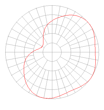 | ||||||||||||||||||
| Azimuth | Ratio | Azimuth | Ratio | Azimuth | Ratio | Azimuth | Ratio | ||||||||||||
| 2 | 0.680 | 12 | 0.758 | 22 | 0.845 | 32 | 0.922 | ||||||||||||
| 42 | 0.975 | 52 | 0.997 | 62 | 0.990 | 72 | 0.959 | ||||||||||||
| 82 | 0.929 | 92 | 0.925 | 102 | 0.951 | 112 | 0.985 | ||||||||||||
| 122 | 1.000 | 132 | 0.985 | 142 | 0.951 | 152 | 0.925 | ||||||||||||
| 162 | 0.929 | 172 | 0.959 | 182 | 0.990 | 192 | 0.997 | ||||||||||||
| 202 | 0.975 | 212 | 0.922 | 222 | 0.845 | 232 | 0.758 | ||||||||||||
| 242 | 0.680 | 252 | 0.605 | 262 | 0.510 | 272 | 0.397 | ||||||||||||
| 282 | 0.302 | 292 | 0.253 | 302 | 0.241 | 312 | 0.253 | ||||||||||||
| 322 | 0.302 | 332 | 0.397 | 342 | 0.510 | 352 | 0.605 | ||||||||||||
Structure Registration Number 1010775 Structure Type: TOWER Registered To: ARA International Structure Address: Pr Rd 797 Km Int Bo Jagueyes Aguas Buenas, PR County Name: Aguas Buenas Municipio ASR Issued: 03/23/2021 Date Built: 04/01/1991 Site Elevation: 450 m (1476 ft.) Structure Height: 68.6 m (225 ft.) Height Overall: 69.5 m (228 ft.) Overall Height AMSL: 519.5 m (1704 ft.) FAA Determination: 10/16/1990 FAA Study #: 90-ASO-1489-OE FAA Circular #: 70/7460-1G Paint & Light FAA Chapters: 3, 4, 5, 9 18-16-25.0 N 66-05-40.0 W (NAD 83) 18-16-32.2 N 66-05-41.4 W (Converted to NAD 27) |
P.o. Box 43 Mayaguez, PR 00681 Phone: 787-831-5555 Corporation | Date: 05/30/2014 Application Certifier TELECINCO, INC. P.o. Box 43 Mayaguez, PR 00681 Applicant ALEJANDRO LUCIANO Po Box 9986 San Juan, PR 00908 DIRECTOR OF ENGINEERING LEE G. PETRO, ESQUIRE Drinker Biddle & Reath, Llp | |||||||||||||||||