
FCCInfo.com
A Service of Cavell, Mertz & Associates, Inc.
(855) FCC-INFO
|
|
|
|
|
||||||||||||||||
|
|
Status: License Application Accepted: 08/17/2009 License Expires: 04/01/2022 File Number: BLDVL-20090817ACX Prefix Type: This is BLDVL FCC Website Links: LMS Facility Details This Application Other K12LO-D Applications Including Superseded Applications Mailing Address Correspondence for K12LO-D Correspondence related to application BLDVL-20090817ACX Service Contour - Open Street Map or USGS Map (48 dBu) Service Contour - KML / Google Earth (48 dBu) Rabbit Ears Info Search for K12LO-D Site Location: 48-04-04.3 N 114-02-19.3 W (NAD 83) Site Location: 48-04-04.5 N 114-02-15.9 W (Converted to NAD 27) ERP: 0.008 kW R/C AGL: 32.9 m (108 ft.) R/C AMSL: 1163.9 m (3819 ft.) Emission Mask: Simple Site Elevation: 1131 m. (3711 ft.) Height Overall*: 32.9 m (108 ft.) (* As Filed In This Application, may differ from ASR Data, Below.) Directional Antenna - Antenna Make/Model: Scala HDCA-5 ARRAY Antenna ID: 89255
| ||||||||||||||||||
| Antenna Data for Antenna Id: 89255 K12LO-D LD File: BLDVL-20090817ACX Scala - HDCA-5 ARRAY Service: LD Standard Pattern: Y | 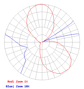 | ||||||||||||||||||
| Azimuth | Ratio | Azimuth | Ratio | Azimuth | Ratio | Azimuth | Ratio | ||||||||||||
| 0 | 1.000 | 10 | 0.939 | 20 | 0.809 | 30 | 0.630 | ||||||||||||
| 40 | 0.464 | 50 | 0.273 | 60 | 0.038 | 70 | 0.019 | ||||||||||||
| 80 | 0.146 | 90 | 0.367 | 100 | 0.553 | 110 | 0.710 | ||||||||||||
| 120 | 0.885 | 130 | 0.972 | 135 | 1.000 | 140 | 0.981 | ||||||||||||
| 150 | 0.956 | 160 | 0.845 | 170 | 0.703 | 180 | 0.527 | ||||||||||||
| 190 | 0.297 | 200 | 0.154 | 210 | 0.122 | 220 | 0.070 | ||||||||||||
| 230 | 0.061 | 240 | 0.052 | 250 | 0.042 | 260 | 0.056 | ||||||||||||
| 270 | 0.068 | 280 | 0.091 | 290 | 0.140 | 300 | 0.181 | ||||||||||||
| 310 | 0.429 | 320 | 0.620 | 330 | 0.774 | 340 | 0.907 | ||||||||||||
| 350 | 0.974 | ||||||||||||||||||
Structure Registration Number 1253697 Structure Type: TOWER Registered To: Swan Hill TV District Structure Address: Swan Hill Communications Site Bigfork, MT County Name: Flathead County ASR Issued: 03/09/2010 Site Elevation: 1130.8 m (3710 ft.) Structure Height: 32.9 m (108 ft.) Height Overall: 32.9 m (108 ft.) Overall Height AMSL: 1163.7 m (3818 ft.) FAA Determination: 05/08/2006 FAA Study #: 2006-ANM-771-OE Paint & Light FAA Chapters: NONE 48-04-04.3 N 114-02-19.3 W (NAD 83) 48-04-04.5 N 114-02-15.9 W (Converted to NAD 27) |
P.o. Box 530 Bigfork, MT 59911 Phone: 406-837-4132 Applicant | Date: 08/17/2009 Application Certifier SWAN HILL TV DIST P.o. Box 530 Bigfork, MT 59911 Applicant B. W. ST. CLAIR 2355 Ranch Drive Westminster, CO 80234 ENGINEERING CONSULTANT RUSSELL PICKETT Swan Hill Tv Dist | |||||||||||||||||