
FCCInfo.com
A Service of Cavell, Mertz & Associates, Inc.
(855) FCC-INFO
|
|
|
Virtual Channel 19 |
|
||||||||||||||||||||||||||||||||||||||||||||||||||||
|
|
Repacking Information: No changes Status: License Application Accepted: 07/17/2014 License Expires: 02/01/2015 File Number: BLCDT-20140717ABN Prefix Type: This is a License for a commercial digital TV station FCC Website Links: LMS Facility Details This Application Other KEPR-TV Applications Including Superseded Applications Mailing Address Correspondence for KEPR-TV Correspondence related to application BLCDT-20140717ABN Service Contour - Open Street Map or USGS Map (41 dBu) Service Contour - KML / Google Earth (41 dBu) Public Inspection Files Rabbit Ears Info Search for KEPR-TV Site Location: 46-05-50.0 N 119-11-33.0 W (NAD 83) Site Location: 46-05-50.5 N 119-11-29.0 W (Converted to NAD 27) ERP: 83 kW Polarization: Elliptically polarized HAAT: 367 m (1204 ft.) Electrical Beam Tilt: 1 degree R/C AGL: 101 m (331 ft.) R/C AMSL: 721.2 m (2366 ft.) Site Elevation: 620.2 m. (2035 ft.) Height Overall*: 107.8 m (354 ft.) (* As Filed In This Application, may differ from ASR Data, Below.) Directional Antenna - Antenna Make/Model: DIELECTRIC TLP-12B/VP-R Antenna ID: 118142 Polarization: Elliptically polarized | ||||||||||||||||||||||||||||||||||||||||||||||||||||||
| Antenna Data for Antenna Id: 118142 KEPR-TV DT File: BLCDT-20140717ABN DIELECTRIC - TLP-12B/VP-R Service: DT Standard Pattern: Y | 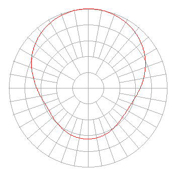 | ||||||||||||||||||||||||||||||||||||||||||||||||||||||
| Azimuth | Ratio | Azimuth | Ratio | Azimuth | Ratio | Azimuth | Ratio | ||||||||||||||||||||||||||||||||||||||||||||||||
| 0 | 1.000 | 10 | 0.996 | 20 | 0.981 | 30 | 0.955 | ||||||||||||||||||||||||||||||||||||||||||||||||
| 40 | 0.920 | 50 | 0.876 | 60 | 0.826 | 70 | 0.771 | ||||||||||||||||||||||||||||||||||||||||||||||||
| 80 | 0.714 | 90 | 0.661 | 100 | 0.615 | 110 | 0.583 | ||||||||||||||||||||||||||||||||||||||||||||||||
| 120 | 0.569 | 130 | 0.571 | 140 | 0.586 | 150 | 0.607 | ||||||||||||||||||||||||||||||||||||||||||||||||
| 160 | 0.627 | 170 | 0.640 | 180 | 0.645 | 190 | 0.641 | ||||||||||||||||||||||||||||||||||||||||||||||||
| 200 | 0.631 | 210 | 0.613 | 220 | 0.592 | 230 | 0.579 | ||||||||||||||||||||||||||||||||||||||||||||||||
| 240 | 0.570 | 250 | 0.579 | 260 | 0.610 | 270 | 0.650 | ||||||||||||||||||||||||||||||||||||||||||||||||
| 280 | 0.699 | 290 | 0.759 | 300 | 0.817 | 310 | 0.869 | ||||||||||||||||||||||||||||||||||||||||||||||||
| 320 | 0.914 | 330 | 0.951 | 340 | 0.975 | 350 | 0.993 | ||||||||||||||||||||||||||||||||||||||||||||||||
Structure Registration Number 1032435 Structure Type: TOWER Registered To: Sinclair Yakima Licensee, LLC Structure Address: S16 T7n R29e Wm Johnson Butte 12.87 Km Sw Kennewick, WA County Name: Benton County ASR Issued: 01/10/2017 Date Built: 01/01/1971 Site Elevation: 620.2 m (2035 ft.) Structure Height: 91.4 m (300 ft.) Height Overall: 107.8 m (354 ft.) Overall Height AMSL: 728 m (2388 ft.) Paint & Light FAA Chapters: 1, 3, 12, 21 46-05-50.0 N 119-11-33.0 W (NAD 83) 46-05-50.5 N 119-11-29.0 W (Converted to NAD 27) |
1200 Seventeenth Street, Nw Washington, DC 20036 Phone: 202-663-8195 Limited Liability Company | Date: 07/17/2014 Application Certifier SINCLAIR LEWISTON LICENSEE, LLC C/o Clifford Harrington, Pillsbury Winth 2300 N Street, Nw Washington, DC 20037 Applicant JOHN E. HIDLE, P.E. Carl T. Jones Corporation 7901 Yarnwood Court Springfield, VA 22153-2827 CONSULTING ENGINEER CLIFFORD M. HARRINGTON, ESQ. Pillsbury Withrop Shaw Pittman Llp 2300 N Street, Nw Washington, DC 20037 | |||||||||||||||||||||||||||||||||||||||||||||||||||||
|
| ||||||||||||||||||||||||||||||||||||||||||||||||||||||