
FCCInfo.com
A Service of Cavell, Mertz & Associates, Inc.
(855) FCC-INFO
|
|
|
|
|
||||||||||||||||
|
|
Status: License Application Accepted: 11/18/2009 License Expires: 02/01/2015 File Number: BLDTT-20091118ACD Prefix Type: This is BLDTT FCC Website Links: LMS Facility Details This Application Other K25JW-D Applications Including Superseded Applications Mailing Address Correspondence for K25JW-D Correspondence related to application BLDTT-20091118ACD Service Contour - Open Street Map or USGS Map (51 dBu) Service Contour - KML / Google Earth (51 dBu) Rabbit Ears Info Search for K25JW-D Site Location: 42-29-21.8 N 123-18-19.7 W (NAD 83) Site Location: 42-29-22.4 N 123-18-15.5 W (Converted to NAD 27) ERP: 0.68 kW R/C AGL: 33 m (108 ft.) R/C AMSL: 987 m (3238 ft.) Emission Mask: Stringent Site Elevation: 954 m. (3130 ft.) Height Overall*: 43 m (141 ft.) (* As Filed In This Application, may differ from ASR Data, Below.) Directional Antenna - Antenna Make/Model: Scala 4DR-4S Antenna ID: 20748
| ||||||||||||||||||
| Antenna Data for Antenna Id: 20748 K25JW-D LD File: BLDTT-20091118ACD Scala - 4DR-4S Service: LD Standard Pattern: Y Pattern and Field Values Include a 180° Clockwise Rotation | 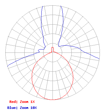 | ||||||||||||||||||
| Azimuth | Ratio | Azimuth | Ratio | Azimuth | Ratio | Azimuth | Ratio | ||||||||||||
| 0 | 0.110 | 10 | 0.100 | 20 | 0.065 | 30 | 0.030 | ||||||||||||
| 40 | 0.020 | 50 | 0.020 | 60 | 0.030 | 70 | 0.040 | ||||||||||||
| 80 | 0.055 | 90 | 0.070 | 100 | 0.115 | 110 | 0.210 | ||||||||||||
| 120 | 0.350 | 130 | 0.510 | 140 | 0.680 | 150 | 0.810 | ||||||||||||
| 160 | 0.915 | 170 | 0.980 | 180 | 1.000 | 190 | 0.980 | ||||||||||||
| 200 | 0.917 | 210 | 0.813 | 220 | 0.680 | 230 | 0.530 | ||||||||||||
| 240 | 0.350 | 250 | 0.140 | 260 | 0.060 | 270 | 0.030 | ||||||||||||
| 280 | 0.030 | 290 | 0.020 | 300 | 0.020 | 310 | 0.020 | ||||||||||||
| 320 | 0.030 | 330 | 0.040 | 340 | 0.070 | 350 | 0.105 | ||||||||||||
Structure Registration Number 1262767 [ASR Heights Differ from K25JW-D Application] Structure Type: GTOWER Registered To: SIS-Q COMMUNICATIONS Structure Address: Gilbert Peak Tower Grants Pass, OR County Name: Josephine County ASR Issued: 02/21/2017 Date Built: 08/12/2005 Site Elevation: 967.4 m (3174 ft.) Structure Height: 43.9 m (144 ft.) Height Overall: 43.9 m (144 ft.) Overall Height AMSL: 1011.3 m (3318 ft.) FAA Determination: 02/15/2017 FAA Study #: 2016-ANM-3698-OE Paint & Light FAA Chapters: NONE Removed expiration date from determination. Scenario 1./jjs/case#635066 42-29-19.7 N 123-18-26.2 W (NAD 83) 42-29-20.3 N 123-18-22.0 W (Converted to NAD 27) |
C/o Miles S. Mason, Esq. - Pillsbury Winthrop 1200 Seventeenth Street Nw Washington, DC 20036 Phone: 202-663-8195 Applicant | Date: 11/18/2009 Application Certifier FREEDOM BROADCASTING OF OREGON LICENSEE, L.L.C., DEBTOR-IN-P 1440 Rossanley Drive Medford, OR 97501 Applicant LOUIS R DUTREIL JR Dutreil Lundin & Rackley Inc 201 Fletcher Ave Sarasota, FL 34237-6019 CONSULTING ENGINEER DAVID D. BURNS Latham & Watkins Llp | |||||||||||||||||