|
K14NI-D
Call Sign History
K14NI-D from 12/08/2009
|
Channel 14DT
|
Ferndale, MT
|
|
Status: LIC
Application Accepted: 12/10/2009
License Expires: 04/01/2030
File Number: BLDTT-20091210ADO
Prefix Type: This is BLDTT
FCC Website Links:
LMS Facility Details
This Application
Other K14NI-D Applications
Including Superseded Applications
Service Contour - Open Street Map or USGS Map (51 dBu)
Service Contour - KML / Google Earth (51 dBu)
Rabbit Ears Info Search for K14NI-D
Site Location: 48-04-04.3 N 114-02-19.3 W (NAD 83)
Site Location: 48-04-04.5 N 114-02-15.9 W (Converted to NAD 27)
ERP: 0.111 kW
R/C AGL: 17.1 m (56 ft.)
R/C AMSL: 1148.1 m (3767 ft.)
Emission Mask: Simple
Site Elevation: 1131 m. (3711 ft.)
Height Overall*: 32.9 m (108 ft.)
(* As Filed In This Application, may differ from ASR Data, Below.)
Directional Antenna - Antenna Make/Model: Scala 1X2KBBU ARRAY
Antenna ID: 95866
| Primary Station |
| KTMF-LD |
Ch. 36 | Kalispell, Montana |
|
Antenna Data for Antenna Id: 95866
K14NI-D LD File: BLDTT-20091210ADO
Scala - 1X2KBBU ARRAY
Service: LD
Standard Pattern: Y
|
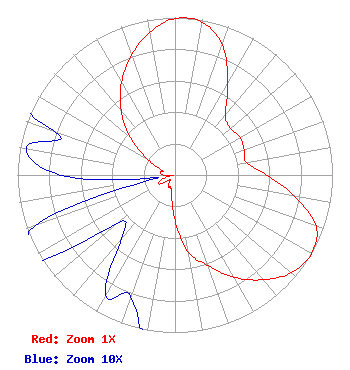 |
| Azimuth | Ratio | Azimuth | Ratio | Azimuth | Ratio | Azimuth | Ratio |
| 0 | 0.994 | 10 | 0.986 | 20 | 0.879 | 30 | 0.668 |
| 40 | 0.498 | 50 | 0.460 | 60 | 0.477 | 70 | 0.467 |
| 80 | 0.460 | 90 | 0.582 | 100 | 0.770 | 110 | 0.953 |
| 120 | 1.000 | 130 | 0.965 | 140 | 0.868 | 150 | 0.750 |
| 160 | 0.611 | 170 | 0.499 | 180 | 0.289 | 190 | 0.123 |
| 200 | 0.082 | 210 | 0.088 | 220 | 0.053 | 230 | 0.048 |
| 240 | 0.115 | 250 | 0.095 | 260 | 0.011 | 270 | 0.073 |
| 280 | 0.096 | 290 | 0.082 | 300 | 0.202 | 310 | 0.372 |
| 320 | 0.531 | 330 | 0.680 | 340 | 0.809 | 350 | 0.921 |
|
Structure Information
Structure Registration Number 1253697
Structure Type: TOWER
Registered To:
Swan Hill TV District
Structure Address:
Swan Hill Communications Site
Bigfork, MT
County Name: Flathead County
ASR Issued: 03/09/2010
Site Elevation: 1130.8 m (3710 ft.)
Structure Height: 32.9 m (108 ft.)
Height Overall: 32.9 m (108 ft.)
Overall Height AMSL: 1163.7 m (3818 ft.)
FAA Determination: 05/08/2006
FAA Study #: 2006-ANM-771-OE
Paint & Light FAA Chapters: NONE
48-04-04.3 N 114-02-19.3 W (NAD 83)
48-04-04.5 N 114-02-15.9 W
(Converted to NAD 27)
|
K14NI-D Licensee Information
Swan Hill TV Dist
P.O. Box 530
Bigfork, MT 59911
Phone: 406-837-4132
Applicant | 20091210ADO Applicant Information
Russell Pickett
Date: 12/10/2009
Application Certifier
Swan Hill TV District
P.O. Box 530
Big Fork, MT 59911
Applicant
Charlie Cannaliato
200 Evans Avenue
Missoula, MT 59801-5831
Consulting Engineer
Russell Pickett
Swan Hill TV District
|
Associated Land Mobile Licenses
|
| (No Records Found) |
| Associated Microwave Licenses
|
| | WRDF801 |
13 GHz TV Translator Relay |
|
