
FCCInfo.com
A Service of Cavell, Mertz & Associates, Inc.
(855) FCC-INFO
|
|
W27EH-D from 06/22/2004 |
|
|
||||||||||||||||
|
|
Status: License Application Accepted: 06/21/2007 License Expires: 06/01/2021 File Number: BLTTL-20070621ARK Prefix Type: This is a license for a UHF LPTV station FCC Website Links: LMS Facility Details This Application Other W27EH-D Applications Including Superseded Applications Mailing Address Correspondence for W27EH-D Correspondence related to application BLTTL-20070621ARK Service Contour - Open Street Map or USGS Map (74 dBu) Service Contour - KML / Google Earth (74 dBu) Rabbit Ears Info Search for W27EH-D Site Location: 31-16-22.1 N 89-21-04.4 W (NAD 83) Site Location: 31-16-21.5 N 89-21-04.2 W (Converted to NAD 27) ERP: 0.12 kW R/C AGL: 118 m (387 ft.) R/C AMSL: 232.6 m (763 ft.) Site Elevation: 114.6 m. (376 ft.) Height Overall*: 123.4 m (405 ft.) (* As Filed In This Application, may differ from ASR Data, Below.) Directional Antenna - Antenna Make/Model: Propagation System Inc PSILP8CRA Antenna ID: 20494 | ||||||||||||||||||
| Antenna Data for Antenna Id: 20494 W27EH-D TX File: BLTTL-20070621ARK Propagation System Inc - PSILP8CRA Service: TX Standard Pattern: Y | 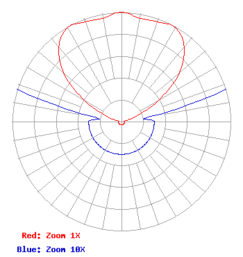 | ||||||||||||||||||
| Azimuth | Ratio | Azimuth | Ratio | Azimuth | Ratio | Azimuth | Ratio | ||||||||||||
| 0 | 1.000 | 10 | 0.960 | 20 | 0.970 | 30 | 0.990 | ||||||||||||
| 40 | 0.890 | 50 | 0.690 | 60 | 0.400 | 70 | 0.150 | ||||||||||||
| 80 | 0.030 | 90 | 0.030 | 100 | 0.030 | 110 | 0.030 | ||||||||||||
| 120 | 0.030 | 130 | 0.030 | 140 | 0.030 | 150 | 0.030 | ||||||||||||
| 160 | 0.030 | 170 | 0.030 | 180 | 0.030 | 190 | 0.030 | ||||||||||||
| 200 | 0.030 | 210 | 0.030 | 220 | 0.030 | 230 | 0.030 | ||||||||||||
| 240 | 0.030 | 250 | 0.030 | 260 | 0.030 | 270 | 0.030 | ||||||||||||
| 280 | 0.030 | 290 | 0.150 | 300 | 0.400 | 310 | 0.690 | ||||||||||||
| 320 | 0.890 | 330 | 0.990 | 340 | 0.970 | 350 | 0.960 | ||||||||||||
Structure Registration Number 1039101 [ASR Heights Differ from W27EH-D Application] Structure Type: TOWER Registered To: Pinnacle Towers LLC Structure Address: 530 Sullivan Kilran Road Hattiesburg, MS County Name: Lamar County ASR Issued: 05/06/2016 Date Built: 01/01/1995 Site Elevation: 114.6 m (376 ft.) Structure Height: 122.2 m (401 ft.) Height Overall: 124.7 m (409 ft.) Overall Height AMSL: 239.3 m (785 ft.) FAA Determination: 05/29/2008 FAA Study #: 2008-ASO-2043-OE FAA Circular #: 70/7460-1H Paint & Light FAA Chapters: 4, 6, 13 PRIOR STUDY 2007-ASO-2540-OE 31-16-22.1 N 89-21-04.4 W (NAD 83) 31-16-21.5 N 89-21-04.2 W (Converted to NAD 27) |
1498 Buford Hwy Ste C 275 Sugar Hill, GA 30518 Phone: 770-771-1644 Corporation | Date: 06/21/2007 Application Certifier PRISM BROADCASTING NETWORK, INC. 7742 Spalding Dr. Suite 475 Norcross, GA 30092 Applicant B. W. ST. CLAIR 2355 Ranch Drive Westminster, CO 80234 ENGINEERING CONSULTANT PRISM BROADCASTING NETWORK, INC. | |||||||||||||||||