
FCCInfo.com
A Service of Cavell, Mertz & Associates, Inc.
(855) FCC-INFO
|
|
WNBD-LD from 02/25/2010 |
|
|
||||||||||||||||
|
|
Status: License Application Accepted: 10/20/2010 License Expires: 06/01/2029 File Number: BLDTL-20101020ACE Prefix Type: This is BLDTL FCC Website Links: LMS Facility Details This Application Other WNBD-LD Applications Including Superseded Applications Mailing Address Correspondence for WNBD-LD Correspondence related to application BLDTL-20101020ACE Service Contour - Open Street Map or USGS Map (51 dBu) Service Contour - KML / Google Earth (51 dBu) Rabbit Ears Info Search for WNBD-LD Site Location: 33-22-23.0 N 90-32-25.0 W (NAD 83) Site Location: 33-22-22.6 N 90-32-24.7 W (Converted to NAD 27) ERP: 15 kW Electrical Beam Tilt: 0.75 degrees R/C AGL: 572 m (1877 ft.) R/C AMSL: 607 m (1991 ft.) Emission Mask: Stringent Site Elevation: 35 m. (115 ft.) Height Overall*: 608 m (1995 ft.) (* As Filed In This Application, may differ from ASR Data, Below.) Directional Antenna - Antenna Make/Model: DIELECTRIC TFU-30DSC-4 3BP300 Antenna ID: 95163 | ||||||||||||||||||
| Antenna Data for Antenna Id: 95163 WNBD-LD LD File: BLDTL-20101020ACE DIELECTRIC - TFU-30DSC-4 3BP300 Service: LD Standard Pattern: Y | 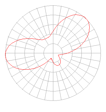 | ||||||||||||||||||
| Azimuth | Ratio | Azimuth | Ratio | Azimuth | Ratio | Azimuth | Ratio | ||||||||||||
| 0 | 0.451 | 10 | 0.606 | 20 | 0.780 | 30 | 0.924 | ||||||||||||
| 40 | 0.995 | 43 | 1.000 | 50 | 0.976 | 60 | 0.868 | ||||||||||||
| 70 | 0.696 | 80 | 0.497 | 90 | 0.314 | 100 | 0.182 | ||||||||||||
| 110 | 0.125 | 113 | 0.123 | 120 | 0.140 | 130 | 0.190 | ||||||||||||
| 140 | 0.244 | 150 | 0.278 | 160 | 0.278 | 170 | 0.244 | ||||||||||||
| 180 | 0.190 | 190 | 0.140 | 197 | 0.123 | 200 | 0.125 | ||||||||||||
| 210 | 0.182 | 220 | 0.314 | 230 | 0.497 | 240 | 0.696 | ||||||||||||
| 250 | 0.868 | 260 | 0.976 | 267 | 1.000 | 270 | 0.995 | ||||||||||||
| 280 | 0.924 | 290 | 0.780 | 300 | 0.606 | 310 | 0.451 | ||||||||||||
| 320 | 0.363 | 330 | 0.338 | 340 | 0.338 | 350 | 0.363 | ||||||||||||
Structure Registration Number 1051861 Structure Type: TOWER Registered To: Imagicomm Greenwood Operations LLC Structure Address: 2.3 Miles Ne Inverness, MS County Name: Sunflower County ASR Issued: 09/27/2022 Date Built: 01/28/1983 Site Elevation: 34.9 m (115 ft.) Structure Height: 585.3 m (1920 ft.) Height Overall: 608.2 m (1995 ft.) Overall Height AMSL: 643.1 m (2110 ft.) Paint & Light FAA Chapters: A1, B, G, H 33-22-23.0 N 90-32-25.0 W (NAD 83) 33-22-22.6 N 90-32-24.7 W (Converted to NAD 27) |
3000 Worldreach Drive Indian Land, SC 29707 Phone: 803-578-1418 Limited Liability Company | Date: 10/20/2010 Application Certifier COMMONWEALTH BROADCASTING GROUP, INC. 1150 Foothill Blvd., Suite D La Canada, CA 91011-3248 Applicant ERIK C. SWANSON, P.E. Hatfield & Dawson Consulting Engineers 9500 Greenwood Ave N Seattle, WA 98103 CONSULTING ENGINEER COMMONWEALTH BROADCASTING GROUP, INC. | |||||||||||||||||