
FCCInfo.com
A Service of Cavell, Mertz & Associates, Inc.
(855) FCC-INFO
|
|
W25AA-D from 11/23/1979 |
|
|
||||||||||||||||
|
|
Status: License Application Accepted: 11/27/2012 License Expires: 10/01/2020 File Number: BLDTT-20121127AMR Prefix Type: This is BLDTT FCC Website Links: LMS Facility Details This Application Other W25AA-D Applications Including Superseded Applications Mailing Address Correspondence for W25AA-D Correspondence related to application BLDTT-20121127AMR Service Contour - Open Street Map or USGS Map (51 dBu) Service Contour - KML / Google Earth (51 dBu) Rabbit Ears Info Search for W25AA-D Site Location: 37-50-32.7 N 75-34-16.1 W (NAD 83) Site Location: 37-50-32.2 N 75-34-17.4 W (Converted to NAD 27) ERP: 7.9 kW Electrical Beam Tilt: 0.5 degrees R/C AGL: 138.4 m (454 ft.) R/C AMSL: 152.4 m (500 ft.) Emission Mask: Simple Site Elevation: 14 m. (46 ft.) Height Overall*: 145.1 m (476 ft.) (* As Filed In This Application, may differ from ASR Data, Below.) Directional Antenna - Antenna Make/Model: R.F. Systems PHP20B Antenna ID: 103029
| ||||||||||||||||||
| Antenna Data for Antenna Id: 103029 W25AA-D LD File: BLDTT-20121127AMR R.F. Systems - PHP20B Service: LD Standard Pattern: Y Pattern and Field Values Include a 35° Clockwise Rotation | 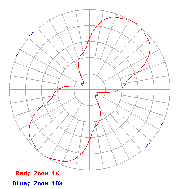 | ||||||||||||||||||
| Azimuth | Ratio | Azimuth | Ratio | Azimuth | Ratio | Azimuth | Ratio | ||||||||||||
| 5 | 0.760 | 15 | 0.920 | 25 | 0.970 | 35 | 1.000 | ||||||||||||
| 45 | 0.970 | 55 | 0.920 | 65 | 0.760 | 75 | 0.510 | ||||||||||||
| 85 | 0.430 | 95 | 0.320 | 105 | 0.150 | 115 | 0.100 | ||||||||||||
| 125 | 0.120 | 135 | 0.100 | 145 | 0.150 | 155 | 0.320 | ||||||||||||
| 165 | 0.430 | 175 | 0.510 | 185 | 0.760 | 195 | 0.920 | ||||||||||||
| 205 | 0.970 | 215 | 1.000 | 225 | 0.970 | 235 | 0.920 | ||||||||||||
| 245 | 0.760 | 255 | 0.510 | 265 | 0.430 | 275 | 0.320 | ||||||||||||
| 285 | 0.150 | 295 | 0.100 | 305 | 0.120 | 315 | 0.100 | ||||||||||||
| 325 | 0.150 | 335 | 0.320 | 345 | 0.430 | 355 | 0.510 | ||||||||||||
Structure Registration Number 1016112 Structure Type: GTOWER Registered To: County of Accomack, Virginia Structure Address: 14306 Lankford Highway Mappsville, VA County Name: Accomack County ASR Issued: 04/18/2019 Date Built: 10/24/2019 Site Elevation: 14 m (46 ft.) Structure Height: 142.3 m (467 ft.) Height Overall: 145.1 m (476 ft.) Overall Height AMSL: 159.1 m (522 ft.) FAA Determination: 02/13/2019 FAA Study #: 2019-AEA-648-OE FAA Circular #: 70/7460-1L Paint & Light FAA Chapters: 4, 8, 12 PRIOR STUDY 2018-AEA-15178-OE 37-50-32.3 N 75-34-17.3 W (NAD 83) 37-50-31.8 N 75-34-18.6 W (Converted to NAD 27) |
Accomac, VA 23301 Phone: 757-787-5715 Government Entity | Date: 11/27/2012 Application Certifier COUNTY OF ACCOMACK, VIRGINIA Po Box 388 Accomac, VA 23301 Applicant DARLENE C. BURTON Po Box 388 23296 Courthouse Avenue, Suite 203 Accomac, VA 23301 EMPLOYEE OF APPLICANT DARLENE C. BURTON County Of Accomack, Virginia | |||||||||||||||||